
Chattooga County is a county located in the northwestern part of the U.S. state of Georgia. As of the 2010 census, the population was 26,015. The county seat is Summerville. The county was created on December 28, 1838.

The Savannah River is a major river in the southeastern United States, forming most of the border between the states of South Carolina and Georgia. Two tributaries of the Savannah, the Tugaloo River and the Chattooga River, form the northernmost part of the border. The Savannah River drainage basin extends into the southeastern side of the Appalachian Mountains just inside North Carolina, bounded by the Eastern Continental Divide. The river is around 301 miles (484 km) long. It is formed by the confluence of the Tugaloo River and the Seneca River. Today this confluence is submerged beneath Lake Hartwell. The Tallulah Gorge is located on the Tallulah River, a tributary of the Tugaloo River that forms the northwest branch of the Savannah River.

The Tallulah River is a 47.7-mile-long (76.8 km) river in Georgia and North Carolina. It begins in Clay County, North Carolina, near Standing Indian Mountain in the Southern Nantahala Wilderness and flows south into Georgia, crossing the state line into Towns County. The river then travels through Rabun County and ends in Habersham County. It cuts through the Tallulah Dome rock formation to form the Tallulah Gorge and its several waterfalls. The Tallulah River intersects with the Chattooga River to form the Tugaloo River at Lake Tugalo in Habersham County, which then joins South Carolina's Seneca River at Lake Hartwell to create the Savannah River which flows southeastward into the Atlantic Ocean.

The Etowah River is a 164-mile-long (264 km) waterway that rises northwest of Dahlonega, Georgia, north of Atlanta. On Matthew Carey's 1795 map the river was labeled "High Town River". On later maps, such as the 1839 Cass County map, it was referred to as "Hightower River", a name that was used in most early Cherokee records.

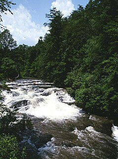
The Chattooga River is the main tributary of the Tugaloo River. Its headwaters are located southwest of Cashiers, North Carolina, and it stretches 57 miles (92 km) to where it has its confluence with the Tallulah River within Lake Tugalo, held back by the Tugalo Dam. The Chattooga and the Tallulah combine to make the Tugaloo River starting at the outlet of Lake Tugalo. The Chattooga begins in southern Jackson County, North Carolina, then flows southwestward between northwestern Oconee County, South Carolina, and eastern Rabun County, Georgia. The "Chattooga" spelling was approved by the US Board on Geographic Names in 1897.
The Treaty of Beaufort, also called the Beaufort Convention, is the treaty that originally set the all-river boundary between the U.S. states of Georgia and South Carolina. It was named for Beaufort, South Carolina, where it was signed in 1787.
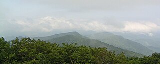
North Georgia is the hilly to mountainous northern region of the U.S. state of Georgia. At the time of the arrival of settlers from Europe, it was inhabited largely by the Cherokee. The counties of north Georgia were often scenes of important events in the history of Georgia. It was the site of many American Civil War battles, including the Battle of Lookout Mountain and the Battle of Chickamauga, leading up to the Atlanta Campaign. Today, particularly in the northeast portion of the region, tourism sustains the local economy.
The Chattooga River runs 64.4 miles (103.6 km) through northwest Georgia and northeast Alabama in the United States. The river begins in Chattooga County, Georgia and flows into Weiss Lake on the Coosa River in Alabama. This river is one of two rivers named Chattooga in the state of Georgia. The other Chattooga River forms part of the boundary between Georgia and South Carolina.
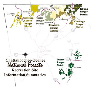
The Tallulah Ranger District is one of the five ranger districts of the Chattahoochee National Forest. The largest portion of the district is located in Rabun County, Georgia, which contains nearly 149,000 acres (600 km2). A portion of the Tallulah Ranger District is also found in Towns County. Both the Appalachian Trail and the Bartram Trail are located in the district.

The Sumter National Forest is one of two forests in South Carolina that are managed together by the United States Forest Service, the other being the Francis Marion National Forest. The Sumter National Forest consists of 370,442 acres (1,499.13 km2) which are divided into several non-contiguous sections in western South Carolina. Overall, in descending order of land area the forest is located in parts of Oconee, Union, Newberry, McCormick, Edgefield, Abbeville, Laurens, Chester, Fairfield, Greenwood, and Saluda counties. Forest headquarters of both South Carolina forests are located together in the state's capital city of Columbia.
The Soque River and its watershed are located entirely within the county boundaries of Habersham County in northeast Georgia. The Soque is a tributary of the Chattahoochee River. Portions of the river run along State Route 197.
Dicks Creek may refer to the following:
Salt Lick Creek is an 11.1-mile-long (17.9 km) tributary of the Susquehanna River in Susquehanna County, Pennsylvania in the United States.
Hazel Creek is a stream in Georgia, and is a tributary of the Soque River. The creek is approximately 13.50 miles (21.73 km) long.
Bad Creek is a stream in the U.S. state of Georgia. It is a tributary to the Chattooga River.
Worse Creek is a stream in the U.S. state of Georgia. It is a tributary to the Chattooga River.
Lick Log Creek may refer to:


