
A Regierungsbezirk means "governmental district" and is a type of administrative division in Germany. Currently, four of sixteen Bundesländer are split into Regierungsbezirke. Beneath these are rural and urban districts.

Lusatia is a historical region in Central Europe, split between Germany and Poland. Lusatia stretches from the Bóbr and Kwisa rivers in the east to the Pulsnitz and Black Elster rivers in the west, and is located within the German states of Saxony and Brandenburg as well as in the Polish voivodeships of Lower Silesia and Lubusz. Lusatia's central rivers are the Spree and the Lusatian Neisse, which constitutes the border between Germany and Poland since 1945. The Lusatian Mountains, separate Lusatia from Bohemia in the south. Lusatia is traditionally divided into Upper Lusatia and Lower Lusatia.

The Province of Silesia was a province of Prussia from 1815 to 1919. The Silesia region was part of the Prussian realm since 1740 and established as an official province in 1815, then became part of the German Empire in 1871. In 1919, as part of the Free State of Prussia within Weimar Germany, Silesia was divided into the provinces of Upper Silesia and Lower Silesia. Silesia was reunified briefly from 1 April 1938 to 27 January 1941 as a province of Nazi Germany before being divided back into Upper Silesia and Lower Silesia.

The Province of Saxony, also known as Prussian Saxony, was a province of the Kingdom of Prussia and later the Free State of Prussia from 1816 until 1944. Its capital was Magdeburg.
The Province of Lower Silesia was a province of the Free State of Prussia from 1919 to 1945. Between 1938 and 1941 it was reunited with Upper Silesia as the Province of Silesia. The capital of Lower Silesia was Breslau. The province was further divided into two administrative regions (Regierungsbezirke), Breslau and Liegnitz.
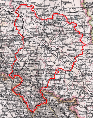
Regierungsbezirk Breslau, known colloquially as Middle Silesia was a Regierungsbezirk, or government region, in the Prussian Province of Silesia and later Lower Silesia from 1813 to 1945. It comprised the eastern parts of the historic Lower Silesia region and the former County of Kladsko, both of which were conquered by Prussia in the First Silesian War in 1742.
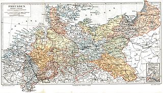
The Provinces of Prussia were the main administrative divisions of Prussia from 1815 to 1946. Prussia's province system was introduced in the Stein-Hardenberg Reforms in 1815, and were mostly organized from duchies and historical regions. Provinces were divided into several Regierungsbezirke, sub-divided into Kreise (districts), and then into Gemeinden (townships) at the lowest level. Provinces constituted the highest level of administration in the Kingdom of Prussia and Free State of Prussia until 1933, when Nazi Germany established de facto direct rule over provincial politics, and were formally abolished in 1946 following World War II. The Prussian provinces became the basis for many federal states of Germany, and the states of Brandenburg, Lower Saxony, and Schleswig-Holstein are direct successors of provinces.

Upper Lusatia is a historical region in Germany and Poland. Along with Lower Lusatia to the north, it makes up the region of Lusatia, named after the Slavic Lusici tribe. Both parts of Lusatia are home to the West Slavic minority group of the Sorbs.

Lower Silesia is the northwestern part of the historical and geographical region of Silesia; Upper Silesia is to the southeast.

The Province of Brandenburg was a province of Prussia from 1815 to 1945. Brandenburg was established in 1815 from the Kingdom of Prussia's core territory, comprised the bulk of the historic Margraviate of Brandenburg and the Lower Lusatia region, and became part of the German Empire in 1871. From 1918, Brandenburg was a province of the Free State of Prussia until Prussia was dissolved in 1945 after World War II, and replaced with reduced territory as the State of Brandenburg in East Germany, which was later dissolved in 1952. Following the reunification of Germany in 1990, Brandenburg was re-established as a federal state of Germany, becoming one of the new states.

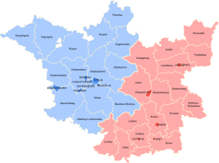
is a town in the Oberspreewald-Lausitz district, in Upper Lusatia, Brandenburg, Germany. It is situated on the river Schwarze Elster, 12 km southwest of Senftenberg.
Grünewald is a municipality in the Oberspreewald-Lausitz district, in Upper Lusatia, Brandenburg, Germany.
Frauendorf is a municipality in the Oberspreewald-Lausitz district, in Upper Lusatia, Brandenburg, Germany.
The Frankfurt Region was a government region in the Prussian Province of Brandenburg between 1815 and 1945. Its administrative capital was Frankfurt (Oder). Today its western part is in the State of Brandenburg while the eastern part, following frontier changes agreed by the Soviet Union in 1945, is part of Poland.

Landkreis Namslau was a district in Prussian Silesia, from 1742 to 1945. The district capital was at Namslau. Today, the territory of the district is located in the Polish Opole Voivodeship.
The District of Oels was a Prussian district in Silesia, which existed from 1742 to 1945. Its capital was the city of Oels. Today, the territory of this district is part of the Polish Lower Silesian Voivodeship.
The District of Ohlau was a Prussian district in Silesia, which existed between 1742 and 1932 and then from 1933 to 1945. The district office was in the city of Ohlau. The territory of this district is now part of the Lower Silesian Voivodeship in Poland.
The district of Glatz was a Prussian district in Silesia, which existed from 1742 to 1945. Its capital was the town of Glatz. Its territory is now part of the Polish Lower Silesian Voivodeship.
The district of Rothenburg was a Prussian district which existed from 1816 to 1947. Today, the territory of the district is split between Germany and Poland by the Lusatian Neisse.
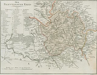
The Fraustadt district was Prussian district which existed in various borders from 1793 to 1945. From 1793 to 1807 it was located in the Province of South Prussia, from 1815 to 1848 in the Grand Duchy of Posen, from 1848 to 1920 in the Province of Posen, from 1922 to 1938, in the Province of Posen-West Prussia, from 1938 to 1941 in the Province of Silesia and from 1941 to 1945 in the Province of Lower Silesia.
