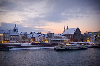
Maastricht is a city and a municipality in the southeastern Netherlands. It is the capital and largest city of the province of Limburg. Maastricht is located on both sides of the Meuse, at the point where the river is joined by the Jeker. Mount Saint Peter (Sint-Pietersberg) is largely situated within the city's municipal borders. Maastricht is adjacent to the border with Belgium and is part of the Meuse-Rhine Euroregion, an international metropolis with a population of about 3.9 million, which includes the nearby German and Belgian cities of Aachen, Liège, and Hasselt.

Utrecht is the fourth-largest city of the Netherlands, as well as the capital and the most populous city of the province of Utrecht. The municipality of Utrecht is located in the eastern part of the Randstad conurbation, in the very centre of mainland Netherlands, and includes Haarzuilens, Vleuten and De Meern. It has a population of 361,699 as of December 2021.

Ede is a town and municipality in the Netherlands, in the province of Gelderland. As of 1 July 2021, Ede had 119,186 inhabitants.

Bodegraven is a town and former municipality in the western Netherlands, in the province of South Holland. The former municipality covers an area of 38.50 km2 (14.86 sq mi) of which 1.02 km2 (0.39 sq mi) is water.
The Randstad is a roughly crescent- or arc-shaped conurbation in the Netherlands, that includes almost half the country's population. With a central-western location, it connects and comprises the Netherlands' four biggest cities, their suburbs, and many towns in between, that all grew and merged into each other. Among other things, it includes the Port of Rotterdam, the Port of Amsterdam, and Amsterdam Airport Schiphol. With a population of approximately 8.4 million people it is one of the largest metropolitan regions in Europe,[b] comparable in population size to the Rhine-Ruhr metropolitan region or the San Francisco Bay Area, and covers an area of approximately 11,372 km2 (4,391 sq mi).[a] The Randstad had a gross regional domestic product of €510 billion in 2022, making it the second most productive region in the European Union, only behind the Paris metropolitan area. It encompasses both the Amsterdam metropolitan area and Rotterdam–The Hague metropolitan area. It is part of the larger Blue Banana megalopolis.

Leidsche Rijn is a new construction site and neighborhood in Utrecht, the capital of the Dutch province of Utrecht. The area is located west of the Amsterdam–Rhine Canal and its name is derived from the Leidse Rijn canal, which runs through it. At the time of its inception in the 1990s and in the decades that followed, Leidsche Rijn was the largest Vinex location in the Netherlands. Most of this location was on the territory of the former municipality of Vleuten-De Meern, located west of the city of Utrecht. A smaller part of this location, namely the area of Hoge and Lage Weide, was located in the municipality of Utrecht.

Den Haag Centraal is the largest railway station in the city of The Hague in South Holland, Netherlands, and with twelve tracks, the largest terminal station in the Netherlands. The railway station opened in 1973, adjacent to its predecessor: Den Haag Staatsspoor, which was subsequently demolished. It is the western terminus of the Gouda–Den Haag railway.

Den Haag HS, an abbreviation of the original name Den Haag Hollands Spoor, is the oldest train station in The Hague, South Holland, Netherlands, located on the Amsterdam–Haarlem–Rotterdam railway. It is the second main station in The Hague and, unlike The Hague Central Station, it is not a terminus station. The name of the station is derived from the former Hollandsche IJzeren Spoorweg-Maatschappij (HIJSM) which was the first Dutch railway company.
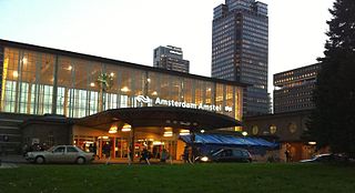
Amsterdam Amstel is a railway station in Amsterdam, Netherlands. The station opened in 1939. It is located to the southeast of Amsterdam Centraal in the borough of Amsterdam-Oost, near the Amstel river. Amsterdam Amstel is used daily by 50,000 train and metro passengers. Rail services at the station are provided by NS, the principal railway operator in the Netherlands. Metro, tram and city bus services are provided by municipal operator GVB. Regional buses are operated by Transdev and Keolis.
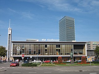
Eindhoven Centraal railway station is the main railway station in Eindhoven in North Brabant, Netherlands. It is the busiest station outside the Randstad area and an important station in the southern part of The Netherlands.
The main public transport in the Netherlands for longer distances is by train. Long-distance buses are limited to a few missing railway connections. Regional and local public transport is by bus and in some cities by metro and tram. There are also ferries.
Voorburg is a railway station located in Voorburg, Netherlands on the Gouda–Den Haag railway. The station was opened on 1 May 1870 and The train services are operated by Nederlandse Spoorwegen. The station is also frequented by several local and some regional public bus-services.
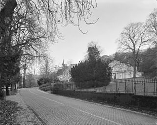
Rijksstraatweg or simply Straatweg was the term for paved roads of interregional significance in the Netherlands in the 19th and early 20th centuries. These roads were built by the national government, and formed the country's first centrally planned highway network. They received route numbers, eventually resulting in a nationwide network of 82 highways. It formed the basis for today's system of nationally controlled roads, the Netherlands' main highway grid.
Following international norms, road signs in Nepal are controlled by the Nepali Department of Roads and are heavily influenced by those used in the United Kingdom.
Halte Amsterdam ArenA (Asdar) is a single rail train halt in the Bijlmermeer neighbourhood of stadsdeel (borough) Amsterdam-Zuidoost in Amsterdam, Netherlands. Situated right at the Johan Cruyff Arena, a football stadium which was previously known as the Amsterdam Arena, the station is specially built for supporter trains deployed during football matches that are considered high risk to the public, such as when local football club AFC Ajax face either Feyenoord, FC Utrecht, PSV or ADO Den Haag. In away matches supporters arrive and depart via this rail station. Regular attendants of the Ajax matches usually arrive via either the Duivendrecht station or the Amsterdam Bijlmer ArenA station. Many away supporters also commonly arrive at the stadium by bus as well.

With 139,000 km of public roads, the Netherlands has one of the most dense road networks in the world – much denser than Germany and France, but still not as dense as Belgium. In 2013, 5,191 km were national roads, 7,778 km were provincial roads, and 125,230 km were municipality and other roads. Dutch roads include 3,530 km of motorways and expressways, and with a motorway density of 64 kilometres per 1,000 km2, the country also has one of the densest motorway networks in the world. In Dutch a motorway is called "autosnelweg" or simply "snelweg"; other expressways are just called "autoweg". According to a 2004 estimate, some 12,500 km of road remain as yet unpaved.

The Netherlands has a public road network totaling 139,000 km, one of the densest in the world. Its use has increased since the 1950s and now exceeds 200 billion km traveled per year, three quarters of which is by car, making it among the most intensely used road networks. In 2019, the World Economic Forum ranked the quality of Dutch road infrastructure as the best in Europe and second to Singapore out of 141 countries.
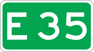
European route E 35 (E 35) is a north–south European route, running from Amsterdam in the Netherlands to Rome in Italy. In the Netherlands, the highway runs from its northern terminus in Amsterdam eastwards through Utrecht and Arnhem to the German border, near Zevenaar. The road runs concurrently with three other motorways over its entire length, starting on Rijksweg 10 (A10) around Amsterdam, then A2 from southern Amsterdam up to Utrecht, and the last part on A12 until it reaches the German border in the east.
