
The Corporation of Trinity House of Deptford Strond, also known as Trinity House, is the official authority for lighthouses in England, Wales, the Channel Islands and Gibraltar. Trinity House is also responsible for the provision and maintenance of other navigational aids, such as lightvessels, buoys, and maritime radio/satellite communication systems. It is also an official deep sea pilotage authority, providing expert navigators for ships trading in Northern European waters.

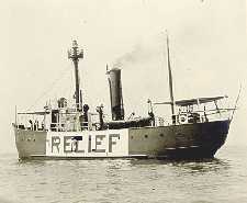
A lightvessel, or lightship, is a ship that acts as a lighthouse. They are used in waters that are too deep or otherwise unsuitable for lighthouse construction. Although some records exist of fire beacons being placed on ships in Roman times, the first modern lightvessel was off the Nore sandbank at the mouth of the River Thames in London, England, placed there by its inventor Robert Hamblin in 1734. The type has become largely obsolete; lighthouses replaced some stations as the construction techniques for lighthouses advanced, while large, automated buoys replaced others.

A buoy is a floating device that can have many purposes. It can be anchored (stationary) or allowed to drift with ocean currents.

The history of the many lightvessel stations of Great Britain goes back over 250 years to the placement of the world's first lightship at the Nore in the early 18th century.
Lightvessels in Ireland describes any lightvessel or light float previously stationed off the coast of Ireland. The Commissioners of Irish Lights are responsible for the majority of marine navigation aids around the whole of the island of Ireland.

A speargun is a ranged underwater fishing device designed to launch a tethered spear or harpoon to impale fish or other marine animals and targets. Spearguns are used in sport fishing and underwater target shooting. The two basic types are pneumatic and elastic. Spear types come in a number of varieties including threaded, break-away and lined. Floats and buoys are common accessories when targeting larger fish.

A surface marker buoy, SMB, dive float or simply a blob is a buoy used by scuba divers, at the end of a line from the diver, intended to indicate the diver's position to people at the surface while the diver is underwater. Two kinds are used; one (SMB) is towed for the whole dive, and indicates the position of the dive group throughout the dive, and the other, a delayed surface marker buoy, DSMB or decompression buoy, is deployed towards the end of the dive as a signal to the surface that the divers have started to ascend, and where they are going to surface. Both types can also function as a depth reference for controlling speed of ascent and accurately maintaining depth at decompression stops. Surface marker buoys are also used by freedivers in open water, to indicate the approximate position of the diver when submerged. They may also be used to support a catch bag or fish stringer by underwater hunters and collectors. A DSMB is considered by recreational scuba divers and service providers to be a highly important item of safety equipment, yet its use is not part of the entry level recreational diver training for all training agencies, and there are significant hazards associated with incompetent use.

A diving shot line, shot line, or diving shot, a type of downline or descending line, is an item of diving equipment consisting of a ballast weight, a line and a buoy. The weight is dropped on the dive site. The line connects the weight and the buoy and is used by divers to as a visual and tactile reference to move between the surface and the dive site more safely and more easily, and as a controlled position for in-water staged decompression stops. It may also be used to physically control rate of descent and ascent, particularly by surface-supplied divers.

The Thames Estuary is where the River Thames meets the waters of the North Sea, in the south-east of Great Britain.
The United States lightship Huron (LV-103) is a lightvessel that was launched in 1920. She is now a museum ship moored in Pine Grove Park, Port Huron, St. Clair County, Michigan.

Sevenstones Lightship is a lightvessel station off the Seven Stones Reef which is nearly 15 miles (24 km) to the west-north-west (WNW) of Land's End, Cornwall, and 7 miles (11 km) east-north-east (ENE) of the Isles of Scilly. The reef has been a navigational hazard to shipping for centuries with seventy-one named wrecks and an estimated two hundred shipwrecks overall, the most infamous being the oil tanker Torrey Canyon on 18 March 1967. The rocks are only exposed at half tide. Since it was not feasible to build a lighthouse, a lightvessel was provided by Trinity House. The first was moored near the reef on 20 August 1841 and exhibited its first light on 1 September 1841. She is permanently anchored in 40 fathoms (73 m) and is 2.5 miles (4.0 km) north-east (NE) of the reef. Since 1987, the Sevenstones Lightship has been automated and unmanned.

Channel was the name of a lightvessel station located in the English Channel between 1979 and August 2021, when it was replaced with a light buoy. It was also one of the 22 coastal weather stations whose conditions were reported in the BBC Shipping Forecast. The vessel's position was 49°55′N2°54′W, approximately 56 km (35 mi) north-northwest of Guernsey.

The Seven Stones reef is a rocky reef nearly 15 miles (24 km) west of Land's End, Cornwall and 7 miles (11 km) east-northeast of the Isles of Scilly. The reef consists of two groups of rocks and is nearly 2 miles (3.2 km) long and 1 mile (1.6 km) in breadth. They rise out of deep water and are a navigational hazard for shipping with 71 named wrecks and an estimated 200 shipwrecks overall. The most infamous is the Torrey Canyon in 1967, which was at that time the world's costliest shipping disaster, and to date, still the worst oil spill on the coast of the United Kingdom.
A mooring in oceanography is a collection of devices connected to a wire and anchored on the sea floor. It is the Eulerian way of measuring ocean currents, since a mooring is stationary at a fixed location. In contrast to that, the Lagrangian way measures the motion of an oceanographic drifter, the Lagrangian drifter.
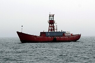
The Varne Bank or Varne Shoal is a 5+3⁄4-mile (9.3 km) long sand bank in the Strait of Dover, lying 9 miles (14 km) southwest of Dover in Kent, England. With the Lobourg Channel running along it, the Varne bank lies immediately south-west of the deepest point 223 feet (68 m) in the strait of Dover. Its rectilinear shape is similar to other banks in the strait such as South Falls bank bordering the Lobourg Channel on the east, the Colbart bank and others. Rectilinear-shaped banks are only present on the English side of the strait.

LANBY, a contraction of Large Automatic Navigation BuoY, was a type of floating navigational aid designed to replace lightships. Now obsolete, they were originally made in the USA by General Dynamics and adapted by Hawker Siddeley Dynamics for use in British waters in the early 1970s. They consisted of a circular hull with a raised central structure containing a 360° light and foghorn, and sometimes also a radio beacon. They were monitored from onshore and designed to run for extended periods without repair. Their running costs were estimated to be as low as 10% of those of lightships.

A fog bell is a navigation mark used as an audible aid to navigation in seafaring, especially in fog and poor visibility. Floating navigation signs with bells are called bell buoys. On ships, the ship's bell is used for sound signals. Due to more suitable sound generators, but also the development and spread of radar, satellite navigation and electronic charting systems, fog bells have lost their importance for maritime navigation.
The Kentish Knock is a long shoal in the North Sea east of Essex, England. It is the most easterly of those of the Thames Estuary and its core, which is shallower than 18 feet (5.5 m), extends 6 miles (9.7 km). Thus it is a major hazard to deep-draught navigation. It is exactly 28 miles (45 km) due east of Foulness Point, Essex and is centred about 15 miles (24 km) NNE of North Foreland, Kent – both are extreme points of those counties.
Five Fathom Bank light station was a station for lightvessels in New Jersey, United States. It was located off the south end of Five Fathom Bank, 14.7 miles and 100 degrees from the Cape May Lighthouse. The station was in service from 1837 to 1972 before ultimately being replaced by a horn buoy.
