The protected areas of Michigan come in an array of different types and levels of protection. Michigan has five units of the National Park Service system. There are 14 federal wilderness areas; the majority of these are also tribal-designated wildernesses. It has one of the largest state forest systems as well having four national forests. The state maintains a large state park system and there are also regional parks, and county, township and city parks. Still other parks on land and in the Great Lakes are maintained by other governmental bodies. Private protected areas also exist in the state, mainly lands owned by land conservancies.

Eagle Island State Park is a public recreation area on the southwest outskirts of the city of Eagle, Idaho. The state park covers 545 acres (221 ha) that are bordered by the north and south channels of the Boise River. The park's recreational facilities include swimming beach, picnic area, equestrian trails, and a water slide.

Wilderness State Park is a public recreation area bordering Lake Michigan, five miles southwest of Mackinaw City in Emmet County in Northern Michigan. The state park's 10,512 acres (4,254 ha) include 26 miles (42 km) of shoreline, diverse forested dune and swale complexes, wetlands, camping areas, and many miles of hiking trails. The state park is operated by the Michigan Department of Natural Resources, which has, as of 2006, approved a proposal that 4,492 acres (1,818 ha) be officially dedicated as a wilderness area. Wilderness State Park was designated a Michigan "dark sky preserve" in 2012.

Burt Lake State Park is a public recreation area covering 406 acres (164 ha) on the south shore of Burt Lake at Indian River in Cheboygan County, Michigan. The state park features over 2000 feet of sandy shoreline, swimming, boating access to the Inland Lakes Waterway, fishing on the Sturgeon River and Burt Lake, and camping facilities.

Fisherman's Island State Park is public recreation area of 2,678 acres (1,084 ha) sitting on six miles (9.7 km) of the Lake Michigan shoreline southwest of Charlevoix, Michigan. Due to historically low lake levels, for most of 1998 to 2016 the small Fisherman Island, for which the state park was named, had become attached to the mainland via a tombolo.
Harrisville State Park is a public recreation area covering 107 acres (43 ha) on the shore of Lake Huron off U.S. Route 23 in Harrisville and Harrisville Township, Alcona County, Michigan. The state park was established at six acres (2.4 ha) in 1921 and was among the first 25 parks created following the inception of the Michigan State Parks Commission in 1919.

Lime Kiln Point State Park is a 42-acre Washington state park on the western shore of San Juan Island in the San Juan archipelago. The park is considered one of the best places in the world to view wild orcas from a land-based facility. Due to the unique bathymetric properties of the site, visitors on the shore can be within 20 feet of whales jumping out of the water. The park was the site of lime kilns beginning in 1860, and one kiln has been restored as a public exhibit.

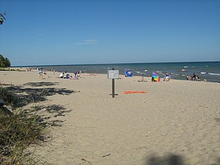
Bay City State Park is a 2,389-acre (967 ha) state park located on the shore of Saginaw Bay near Bay City in Bay County, Michigan, United States. The Tobico Marsh, one of the largest remaining freshwater, coastal wetlands on the Great Lakes is located in the park. Other natural features of the park include a mile of sandy beach, over 2,000 acres (810 ha) of wetland woods, meadows, oak savannah prairies, and cattail marshes. The park is a haven for migratory birds and wetland wildlife.

The Michigan Department of Natural Resources (DNR) is the agency of the state of Michigan charged with maintaining natural resources such as state parks, state forests, and recreation areas. It is governed by a director appointed by the Governor and accepted by the Natural Resources Commission. Currently the Director is Keith Creagh. The DNR has about 1,400 permanent employees, and over 1,600 seasonal employees.

Webb Memorial State Park is a public recreation area located on a peninsula that extends nearly half a mile into the Hingham Bay area of Boston Harbor in Massachusetts. It is composed of three connected drumlins and a low marsh area. The state park forms the only mainland portion of the Boston Harbor Islands National Recreation Area.

M-156 is a state trunkline highway in the US state of Michigan. The highway is entirely within Lenawee County and begins in Morenci at the Ohio state line with State Route 108 (SR 108) and runs north to M-34 at Clayton. The highway runs through farm land along Lime Creek outside of the two communities, providing access to the Lake Hudson State Recreation Area. The trunkline dates back to the early 1930s, and has been unchanged since a realignment in 1980.

Pinckney State Recreation Area is a Michigan state recreation area in Dexter, Sylvan and Lyndon Townships, Washtenaw County and Putnam and Unadilla Townships, Livingston County in the U.S. state of Michigan. The park is 11,000 acres (4,500 ha) and sits at an elevation of 922 feet (281 m). The park is connected to the nearby Waterloo State Recreation Area by the 35-mile (56 km) Waterloo–Pinckney Trail. Pinckney State Recreation Area is open for year-round recreation including hiking, fishing, swimming, hunting and a variety of winter sports.

Rifle River State Recreation Area is a state park located on the upper reaches of the Rifle River within the Au Sable State Forest in Ogemaw County in the U.S. state of Michigan. Covering 4,449 acres (1,800 ha), the area provides a variety of recreational opportunities, including boating, canoeing, hiking, hunting, fishing, cross-country skiing, biking, and swimming.
Yankee Springs State Recreation Area is a state-managed protected area located in Yankee Springs Township in Barry County, Michigan.
Island Lake State Recreation Area is a state-run park in Green Oak Township, Livingston County, in metro Detroit in Michigan. The 4,000-acre (1,600 ha) park lies on the Huron River just downstream of Kensington Metropark with which it is also connected by a bike trail. It is the third busiest park operated by the Michigan Department of Natural Resources with visitation of 1.09 million in 2008. The park is easily accessed as it lies near the intersection of I-96 and US-23. The park has a group campsite and a canoe-in campsite, several miles of hiking and biking trails, a shooting range, swimming and a couple of small lakes. It is the only Michigan park to have a hot air balloon launch area.
Bass River State Recreation Area is a 1,665-acre (674 ha) recreation area, located in Allendale Charter Township and Robinson Township, Ottawa County, Michigan. There is a multi-purpose, 6-mile (9.7 km) trail that is used for cross country skiing, hiking, horseback riding and mountain biking. A gravel boat launch provides access to Max Lake and the Grand River. Hunting is allowed in the recreation area.
Lime Island State Recreation Area is a 980 acres (400 ha) undeveloped state park in the U.S. state of Michigan. The recreation area is located on Lime Island in the St. Marys River near its mouth. The park has no facilities except 5 primitive boat-in campsites. The park was purchased in 1982 and managed by the state's Forest Management Division until it was transferred to the Parks Department in 2011, becoming the 99th park unit. Lime Island contains historic sites from its history as summer camps of Woodland Indians, a lime kiln site, ship bunkering site, and a resort. Lime Island was one of the state forest campgrounds slated to be shut down due to funding cuts until it was transferred to the park program.
Watkins Lake State Park and County Preserve is a combination public recreation area and nature preserve located five miles west of Manchester in Jackson and Washtenaw counties, Michigan. The area occupies a total of 1,122 acres (454 ha), with the Michigan Department of Natural Resources owning 717 acres (290 ha) in Norvell Township, Jackson County, and Washtenaw County owning 405 acres (164 ha) in Manchester Township. Dedicated in 2017, it is under the joint management of the Michigan DNR and the Washtenaw County Parks & Recreation Commission. A five-mile former rail corridor runs through the park and into grasslands in the eastern portion of the preserve.


