Look up Limehouse in Wiktionary, the free dictionary.
Limehouse is a district in London, England.
Contents
Limehouse may also refer to:
Limehouse is a district in London, England.
Limehouse may also refer to:

Bermondsey is a district in southeast London, part of the London Borough of Southwark, England, 2.5 miles (4.0 km) southeast of Charing Cross. To the west of Bermondsey lies Southwark, to the east Rotherhithe and Deptford, to the south Walworth and Peckham, and to the north is Wapping across the River Thames. It lies within the historic county boundaries of Surrey. During the Industrial Revolution Bermondsey became a centre for manufacturing, particularly in relation to tanning. More recently it has experienced regeneration including warehouse conversions to flats and the provision of new transport links.
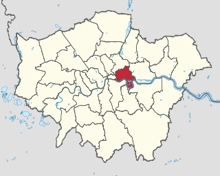
Limehouse is a district in the London Borough of Tower Hamlets in East London. It is 3.9 miles (6.3 km) east of Charing Cross, on the northern bank of the River Thames. Its proximity to the river has given it a strong maritime character, which it retains through its riverside public houses and steps, such as The Grapes and Limehouse Stairs. It is part of the traditional county of Middlesex. It became part of the ceremonial County of London following the passing of the Local Government Act 1888, and then part of Greater London in 1965. It is located between Stepney to the west and north, Mile End and Bow to the northwest, Poplar to the east, and Canary Wharf and Millwall to the south, and stretches from the end of Cable Street and Butcher Row in the west to Stainsby Road near Bartlett Park in the east, and from West India Dock and the River Thames in the south to Salmon Lane and Rhodeswell Road in the north.

Paddington is an area in the City of Westminster, in central London, England. A medieval parish then a metropolitan borough, it was integrated with Westminster and Greater London in 1965. Paddington station, designed by the engineer Isambard Kingdom Brunel opened in 1847. It is also the site of St Mary's Hospital and the former Paddington Green Police Station.

Poplar is a district in East London, England, now part of the London Borough of Tower Hamlets. Five miles (8 km) east of Charing Cross, it is part of the East End.
The London Borough of Tower Hamlets is a London, England borough covering much of the traditional East End. It was formed in 1965 from the merger of the former metropolitan boroughs of Stepney, Poplar, and Bethnal Green. 'Tower Hamlets' was originally an alternative name for the historic Tower Division; the area of south-east Middlesex, focused on the area of the modern borough, which owed military service to the Tower of London.

The Chesterfield Canal is a narrow canal in the East Midlands of England and it is known locally as 'Cuckoo Dyke'. It was one of the last of the canals designed by James Brindley, who died while it was being constructed. It was opened in 1777 and ran for 46 miles (74 km) from the River Trent at West Stockwith, Nottinghamshire to Chesterfield, Derbyshire, passing through the Norwood Tunnel at Kiveton Park, at the time one of the longest tunnels on the British canal system. The canal was built to export coal, limestone, and lead from Derbyshire, iron from Chesterfield, and corn, deals, timber, groceries and general merchandise into Derbyshire. The stone for the Palace of Westminster was quarried in North Anston, Rotherham, and transported via the canal.

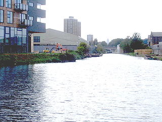
The Limehouse Cut is a largely straight, broad canal in the East End of London which links the lower reaches of the Lee Navigation to the River Thames. Opening on 17 September 1770, and widened for two-way traffic by 1777, it is the oldest canal in the London area. Although short, it has a diverse social and industrial history. Formerly discharging directly into the Thames, since 1968 it has done so indirectly by a connection through Limehouse Basin.

Limehouse Basin is a body of water 2 miles east of London Bridge that is also a navigable link between the River Thames and two of London's canals. First dug in 1820 as the eastern terminus of the new Regent's Canal, its wet area was less than 5 acres originally, but it was gradually enlarged in the Victorian era, reaching a maximum of double that size, when it was given its characteristic oblique entrance lock, big enough to admit 2,000-ton ships.

Regent's Canal is a canal across an area just north of central London, England. It provides a link from the Paddington Arm of the Grand Union Canal, 550 yards (500 m) north-west of Paddington Basin in the west, to the Limehouse Basin and the River Thames in east London. The canal is 8.6 miles (13.8 km) long.
The Hertford Union Canal or Duckett's Cut, just over 1 mile (1.6 km) long, connects the Regent's Canal to the Lee Navigation in the London Borough of Tower Hamlets in East London. It was opened in 1830 but quickly proved to be a commercial failure. It was acquired by the Regents Canal Company in 1857, and became part of the Grand Union Canal in 1927.

The Limehouse Link tunnel is a 1.1-mile (1.8 km) long tunnel under Limehouse in East London on the A1203 road. The tunnel links the eastern end of The Highway to Canary Wharf in London Docklands. Built between 1989 and 1993 at a cost of £293,000,000 it has been calculated as the most expensive road scheme in Britain per mile, working out at £50,500 per foot at 2011 prices. It is the second largest non-estuarial road tunnel in the UK, after the Hindhead Tunnel in Surrey.

Narrow Street is a narrow road running parallel to the River Thames through the Limehouse area of east London, England. It used to be much narrower, and is the oldest part of Limehouse, with many buildings originating from the eighteenth century.

The Highway, part of which was formerly known as the Ratcliffe Highway, is a road in the London Borough of Tower Hamlets, in the East End of London. The route dates back to Roman times. In the 19th century it had a reputation for vice and crime and was the location of the Ratcliff Highway murders. Prior to a renaming programme of 1937, different parts of the route had different names depending on what district they were in.

Blisworth is a village and civil parish in the West Northamptonshire, England. The West Coast Main Line, from London Euston to Manchester and Scotland, runs alongside the village partly hidden and partly on an embankment. The Grand Union Canal passes through the village and the north portal of the Blisworth tunnel is near Stoke Road.

Poplar and Limehouse is a constituency created in 2010 and represented in the House of Commons of the UK Parliament since 2019 by Apsana Begum of the Labour Party. From its creation until 2019, it was represented by Jim Fitzpatrick, also of Labour.

The City Road Basin is an English canal basin and part of the Regent's Canal in Central London, owned by the Canal & River Trust. It opened in 1820, and made a large contribution to the prosperity of the Regent's Canal. By the 1950s, its surroundings were largely derelict, but a programme of regeneration began in 2004, involving several large-scale residential developments, and public access to the basin was provided for the first time in 2009. The basin is used for canoeing by the Islington Boat Club.
Britannia Stop Lock was a lock on the Limehouse Cut in the London Borough of Tower Hamlets. It was built in 1853. The gates were either side of Commercial Road bridge and were oriented such that a boat travelling from south-west to north-east would ascend in height.

City Road Lock is a lock on the Regent's Canal, in the London Borough of Islington, England. It is located a short distance to the east of Islington Tunnel, and immediately to the west of City Road Basin.

Maida Hill Tunnel is a canal tunnel on the Regent's Canal in London, England. The two other tunnels on the Regent's Canal are Islington Tunnel and Eyre's Tunnel.

Angel is an area on the northern fringes of Central London within the London Borough of Islington. It is 2 miles (3.2 km) north-northeast of Charing Cross on the Inner Ring Road at a busy transport intersection. The area is identified in the London Plan as one of 35 major centres in London. It is a significant commercial and retail centre, and a business improvement district. Angel straddles the ancient boundary of the parishes of Clerkenwell and Islington that later became the metropolitan boroughs of Finsbury and Islington. It is named from the former Angel Inn which stood on the corner of Islington High Street and Pentonville Road. Since 1965 the whole area has formed part of the London Borough of Islington in Greater London.