External links
Coordinates: 68°30′N165°15′W / 68.500°N 165.250°W
| | This article about a location in the North Slope Borough, Alaska is a stub. You can help Wikipedia by expanding it. |
The Lisburne Peninsula is a peninsula jutting out into the Chukchi Sea on the western coast of the U.S. state of Alaska. It is located at the westernmost point of the North Slope Borough. It is roughly trapezoid-shaped, having two points, the northwestern one being Cape Lisburne and the southwestern one Point Hope. It is limited on its eastern side by the De Long Mountains. Lat 683000N Long 1651500W
The Lisburne Peninsula extends W, 100 km (62 mi), from a line between Cape Beaufort and Kivalina, into the Chukchi Sea. It separates Alaska's North Slope from the Kotzebue Sound. It is named for Cape Lisburne. Two sections of the Chukchi Sea unit of the Alaska Maritime National Wildlife Refuge are located on the peninsula, one at Cape Lisburne and the other at Cape Thompson.
The Kukpuk River flows through the Lisburne Peninsula.
Coordinates: 68°30′N165°15′W / 68.500°N 165.250°W
| | This article about a location in the North Slope Borough, Alaska is a stub. You can help Wikipedia by expanding it. |

The North Slope Borough is the northernmost borough in the US state of Alaska. The borough seat and largest city is Utqiaġvik, which is also the northernmost settlement in the United States.

Point Hope is a city in North Slope Borough, Alaska, United States. At the 2010 census the population was 674, down from 757 in 2000.

Chukotka Autonomous Okrug or Chukotka (Чукотка) is the easternmost federal subject in Russia. It is geographically located in the Far East region of the country, and is administratively part of the Far Eastern Federal District. Chukotka is the 2nd-least-populated federal subject at 50,526 (2010) and the least densely populated.

Chukchi Sea, sometimes referred to as the Chuuk Sea, Chukotsk Sea or the Sea of Chukotsk, is a marginal sea of the Arctic Ocean. It is bounded on the west by the Long Strait, off Wrangel Island, and in the east by Point Barrow, Alaska, beyond which lies the Beaufort Sea. The Bering Strait forms its southernmost limit and connects it to the Bering Sea and the Pacific Ocean. The principal port on the Chukchi Sea is Uelen in Russia. The International Date Line crosses the Chukchi Sea from northwest to southeast. It is displaced eastwards to avoid Wrangel Island as well as the Chukotka Autonomous Okrug on the Russian mainland.

The Seward Peninsula is a large peninsula on the western coast of the U.S. state of Alaska whose westernmost point is Cape Prince of Wales. The peninsula projects about 320 kilometers (200 mi) into the Bering Sea between Norton Sound, the Bering Strait, the Chukchi Sea, and Kotzebue Sound, just below the Arctic Circle. The entire peninsula is about 330 kilometers (210 mi) long and 145 km (90 mi)-225 km (140 mi) wide. Like Seward, Alaska, it was named after William H. Seward, the United States Secretary of State who fought for the U.S. purchase of Alaska.

The Chukchi Peninsula, at about 66° N 172° W, is the easternmost peninsula of Asia. Its eastern end is at Cape Dezhnev near the village of Uelen. The Chukotka Mountains are located in the central/western part of the peninsula, which is bordered by the Chukchi Sea to the north, the Bering Sea to the south, and the Bering Strait to the east. The peninsula is part of Chukotka Autonomous Okrug of Russia. The peninsula is traditionally the home of tribes of the indigenous peoples of Siberia as well as some Russian settlers.

The Alaska Maritime National Wildlife Refuge is a United States National Wildlife Refuge comprising 2,400 islands, headlands, rocks, islets, spires and reefs in Alaska, with a total area of 4.9 million acres (20,000 km2), of which 2.64 million acres (10,700 km2) is wilderness. The refuge stretches from Cape Lisburne on the Chukchi Sea to the tip of the Aleutian Islands in the west and Forrester Island in the southern Alaska Panhandle region in the east. The refuge has diverse landforms and terrains, including tundra, rainforest, cliffs, volcanoes, beaches, lakes, and streams.

The Kasegaluk Lagoon is a coastal lagoon located in the western part of the North Slope of Alaska. It is separated from the Chukchi Sea by a series of long, thin barrier islands that stretch south and north-east from the town of Point Lay and westwards down to Icy Cape. There are seven passes through these islands. The lagoon receives the waters from the Kukpowruk, Kokolik, and Utukok Rivers.
Cape Lisburne LRRS Airport is a military airport located on Cape Lisburne, at the northwest point of the Lisburne Peninsula in the North Slope Borough of the U.S. state of Alaska. The airport is owned by the U.S. Air Force. It is also known as Cape Lisburne Airport.

The Pitmegea River is a 42-mile (68 km) stream in the western North Slope Borough of the U.S. state of Alaska. From its source in the De Long Mountains, the river flows generally northwest to the Chukchi Sea at Cape Sabine, about 30 miles (48 km) east of Cape Lisburne A prospector who explored the river in 1888 reported its Inuit name as Pitmegeak.
The Kukpuk River is a stream, about 125 miles (201 km) long, in the western North Slope Borough of the U.S. state of Alaska. It flows generally west from the De Long Mountains across the Lisburne Peninsula to Marryat Inlet on the Chukchi Sea. The river mouth is about 12 miles (19 km) northeast of Point Hope.

Cape Lisburne is a cape located at the northwest point of the Lisburne Peninsula on the Chukchi Sea coast in Alaska. It is 40 miles (64 km) northeast of the village of Point Hope, part of the Arctic Slope. It is a part of the Chukchi Sea unit of Alaska Maritime National Wildlife Refuge.

Cape Espenberg is a cape located on the Seward Peninsula in Alaska, on the Chukchi Sea coast.
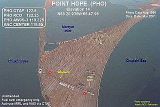
Point Hope Airport is a state-owned public-use airport located two miles (3 km) southwest of the central business district of Point Hope, a city in the North Slope Borough of the U.S. state of Alaska. Point Hope is located in the Lisburne Peninsula, on the Chukchi Sea coast.
Cape Thompson is a headland on the Chukchi Sea coast of Alaska. It is located 26 miles (42 km) to the southeast of Point Hope, Arctic Slope. It is part of the Chukchi Sea unit of Alaska Maritime National Wildlife Refuge.

Point Hope is a headland in the U.S. state of Alaska, located at the western tip of the Lisburne Peninsula. It lies on the Chukchi Sea coast, 40 miles southwest of Cape Lisburne, Arctic Slope at 68°20′27″N166°50′00″W. The city of Point Hope is located on the foreland.

The borders of the oceans are the limits of Earth's oceanic waters. The definition and number of oceans can vary depending on the adopted criteria. The principal divisions of the five oceans are the: Pacific Ocean, Atlantic Ocean, Indian Ocean, Southern (Antarctic) Ocean, and Arctic Ocean. Smaller regions of the oceans are called seas, gulfs, bays, straits, and other terms. Geologically, an ocean is an area of oceanic crust covered by water.
Cape Lisburne Air Force Station is a closed United States Air Force General Surveillance Radar station. It is located 276.5 miles (445.0 km) west-southwest of Point Barrow, Alaska.
Cape Sabine is a cape at Chukchi Sea in North Slope Borough, Alaska, United States.
Risky Creek is a stream in North Slope Borough, Alaska, in the United States. It flows to the Chukchi Sea.