
Lake Huron is one of the five Great Lakes of North America. Hydrologically, it comprises the easterly portion of Lake Michigan–Huron, having the same surface elevation as Lake Michigan, to which it is connected by the 5-mile-wide (8.0 km), 20-fathom-deep Straits of Mackinac. It is shared on the north and east by the Canadian province of Ontario and on the south and west by the U.S. state of Michigan. The name of the lake is derived from early French explorers who named it for the Huron people inhabiting the region.

Alcona County is a county of the U.S. state of Michigan. As of the 2020 Census, the population was 10,167. Its county seat is Harrisville. Alphabetically it is the first county in Michigan; as its flag states, it is the "First of 83".

Harrisville is a city in the U.S. state of Michigan and the county seat of Alcona County. The population was 493 at the 2010 census, making Harrisville the sixth-smallest city by population in the state of Michigan. The city is surrounded by Harrisville Township but is administratively autonomous. Located on Lake Huron, it is an official Michigan Department of Natural Resources Harbor of Refuge.

Benton Township is a civil township of Cheboygan County in the U.S. state of Michigan. As of the 2010 census, the township population was 3,206.
Black River is a common name for streams and communities around the world: in Spanish and Portuguese, Rio Negro; in French, Rivière Noire; in Turkish, Kara Su; in Serbo-Croatian, Crna Reka, Црна Река or Crna Rijeka, Црна Ријека; in Macedonian, Црна Река, Crna Reka.

M-27 is a north–south state trunkline highway in the extreme north of the Lower Peninsula of the US state of Michigan. The trunkline runs between Interstate 75 (I-75) just north of Indian River and Cheboygan, where it meets US Highway 23 (US 23) near Lake Huron. It remains as a relic of the old US 27 which disappeared north of Grayling after being supplanted by I-75, which lies close to old US 27 between Grayling and Indian River.
The Thumb is a region and a peninsula of the U.S. state of Michigan, so named because the Lower Peninsula is shaped like a mitten. The Thumb area is generally considered to be in the Central Michigan region, east of the Tri-Cities and north of Metro Detroit. The region is also branded as the Blue Water Area.

Northern Michigan, also known as Northern Lower Michigan, is a region of the U.S. state of Michigan. A popular tourist destination, it is home to several small- to medium-sized cities, extensive state and national forests, lakes and rivers, and a large portion of Great Lakes shoreline. The region has a significant seasonal population much like other regions that depend on tourism as their main industry. Northern Lower Michigan is distinct from the more northerly Upper Peninsula and Isle Royale, which are also located in "northern" Michigan. In the northernmost 21 counties in the Lower Peninsula of Michigan, the total population of the region is 506,658 people.

Lake Michigan–Huron is the body of water combining both Lake Michigan and Lake Huron, which are joined through the 5-mile-wide (8.0 km), 20-fathom-deep, open-water Straits of Mackinac. Huron and Michigan are hydrologically a single lake because the flow of water through the straits keeps their water levels in overall equilibrium. Although the flow is generally eastward, the water moves in either direction depending on local conditions. Combined, Lake Michigan–Huron is the largest freshwater lake by area in the world. However, Lake Superior is larger than either individually, and so is counted as the largest lake when Lake Huron and Lake Michigan are considered separately.

Pine River may refer to any of the following rivers in the U.S. state of Michigan:

The Cheboygan River is a short but significant river in the Lake Huron drainage basin of the U.S. state of Michigan.

Michigan consists of two peninsulas surrounded primarily by four of the Great Lakes and a variety of nearby islands. The Upper Peninsula is bounded on the southwest by Wisconsin, and the Lower Peninsula is bounded on the south by Indiana and Ohio. Both land masses are also separated from the Canadian province of Ontario by waterways of the Great Lakes, and from each other by the Straits of Mackinac. Because its land is largely surrounded by the Great Lakes, which flow into the Saint Lawrence River, Michigan is the only U.S. state whose streams and rivers are almost entirely within the Great Lakes-St. Lawrence watershed.
The Michigan Department of Health and Human Services (MDHHS) is a principal department of state of Michigan, headquartered in Lansing, that provides public assistance, child and family welfare services, and oversees health policy and management.
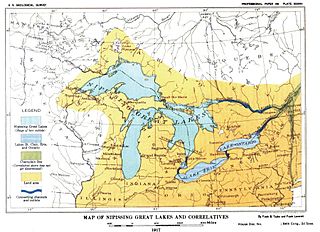
Nipissing Great Lakes was a prehistoric proglacial lake. Parts of the former lake are now Lake Superior, Lake Huron, Georgian Bay and Lake Michigan. It formed about 7,500 years before present (YBP). The lake occupied the depression left by the Labradorian Glacier. This body of water drained eastward from Georgian Bay to the Ottawa valley. This was a period of isostatic rebound raising the outlet over time, until it opened the outlet through the St. Clair valley.

The Mackinac Bands of Chippewa and Ottawa Indians is a state recognized tribe of Ojibwe and Odawa Native Americans, based in the state Michigan. The tribe is headquartered in St. Ignace, Mackinac County and has around 4,000 enrolled members. Today most tribal members live in Mackinac, Chippewa, Emmet, Cheboygan, and Presque Isle counties, however many tribal members are also located throughout the state of Michigan and the United States.

Black River Island is an island in Lake Huron. It is part of a series of shoals around the mouth of Black River and is 3⁄4 mile (1.21 km) NE of it. The island is included within the unincorporated community of Black River in Alcona Township.
