Black River (Southwest Michigan)

Last updated
Black River

SouthHavenLightSouthPier.jpg

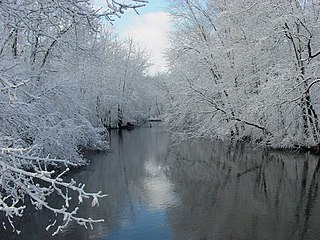
Black River flowing into Lake Michigan
Country United States
Physical characteristics
River mouth Lake Michigan at South Haven, Michigan
581 ft (177 m) [1]

Black River is a 4.2-mile-long (6.8 km) [2] river in the southwest part of the U.S. state of Michigan that empties into Lake Michigan in South Haven at 42°24′08″N86°17′04″W / 42.40222°N 86.28444°W / 42.40222; -86.28444 (Black River (mouth)) , [1] where it discharges past the South Pier Lighthouse. The river takes its name from the dark brown color of its water, which is caused by suspended sediments and organic materials picked up along its course. The river supports a variety of wildlife including trout, snapping turtles, leeches, and many other varieties of flora and fauna. The Black River watershed encompasses 287 square miles (740 km2) across two counties and 13 townships. [3]

U.S. state constituent political entity of the United States

In the United States, a state is a constituent political entity, of which there are currently 50. Bound together in a political union, each state holds governmental jurisdiction over a separate and defined geographic territory and shares its sovereignty with the federal government. Due to this shared sovereignty, Americans are citizens both of the federal republic and of the state in which they reside. State citizenship and residency are flexible, and no government approval is required to move between states, except for persons restricted by certain types of court orders. Four states use the term commonwealth rather than state in their full official names.

Michigan State of the United States of America

Michigan is a state in the Great Lakes and Midwestern regions of the United States. The state's name, Michigan, originates from the Ojibwe word mishigamaa, meaning "large water" or "large lake". With a population of about 10 million, Michigan is the tenth most populous of the 50 United States, with the 11th most extensive total area, and is the largest state by total area east of the Mississippi River. Its capital is Lansing, and its largest city is Detroit. Metro Detroit is among the nation's most populous and largest metropolitan economies.

Lake Michigan one of the Great Lakes of North America

Lake Michigan is one of the five Great Lakes of North America and the only one located entirely within the United States. The other four Great Lakes are shared by the U.S. and Canada. It is the second-largest of the Great Lakes by volume and the third-largest by surface area, after Lake Superior and Lake Huron. To the east, its basin is conjoined with that of Lake Huron through the wide Straits of Mackinac, giving it the same surface elevation as its easterly counterpart; the two are technically a single lake.

Contents

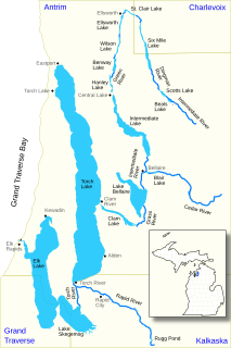
The main course of the river is formed by the confluence of the North Branch Black River and Middle Branch Black River at 42°25′57″N86°14′00″W / 42.43250°N 86.23333°W / 42.43250; -86.23333 (Black River (source)) , northwest of South Haven. The South Branch Black River joins the main course at 42°25′04″N86°15′01″W / 42.41778°N 86.25028°W / 42.41778; -86.25028 (Black River (source)) . [4]

The North Branch Black River is formed out of the Black River Drain, which rises out of a complex of drains including the Leverich Drain and North State Road Drain in Clyde Township and Ganges Township in Allegan County. The Middle Branch Black River is formed by the junction of the Little Bear Lake Drain and Melvin Creek at 42°25′04″N86°15′01″W / 42.41778°N 86.25028°W / 42.41778; -86.25028 (Middle Branch Black River (source)) [5] in southern Lee Township, near the boundary with Van Buren County. The South Branch Black River is formed by the junction of the Lower Jeptha Lake Drain and the Black River Extension Drain at 42°20′10″N86°02′19″W / 42.33611°N 86.03861°W / 42.33611; -86.03861 (South Branch Black River (source)) in Columbia Township near Breedsville. [4]

Clyde Township, Allegan County, Michigan Township in Michigan, United States

Clyde Township is a civil township of Allegan County in the U.S. state of Michigan. The population was 2,084 at the 2010 census.

Ganges Township, Michigan Township in Michigan, United States

Ganges Township is a civil township of Allegan County in the U.S. state of Michigan. The population was 2,530 at the 2010 census.

Allegan County, Michigan County in the United States

Allegan County is a county in the U.S. state of Michigan. As of 2010 United States Census, the population was 111,408. The county seat is Allegan. The name was coined by Henry Rowe Schoolcraft to sound like a Native American word.

About three miles above its mouth on Lake Michigan, the river forks, with the South Branch draining Van Buren County. Less than three miles further upstream, the river forks again into the Middle and North Branches. The Middle branch drains areas of both Van Buren and Allegan counties, and the North Branch watershed is entirely in Allegan County.

Van Buren County, Michigan County in the United States

Van Buren County is a county located in the U.S. state of Michigan. As of the 2010 census, the population was 76,258. The county seat is Paw Paw. The county was founded in 1829 and organized in 1837.

Tributaries

From the mouth:

Related Research Articles

Paw Paw River river in Michigan

The Paw Paw River is located in the U.S. state of Michigan in the southwest portion of the lower peninsula. It is formed by the confluence of the north and south branches at 42°15′17″N85°55′36″W in Waverly Township in the northeast of Van Buren County. It flows approximately 61.8 miles (99.5 km) through Van Buren County and Berrien County until joining the St. Joseph River just above its mouth on Lake Michigan at Benton Harbor.

St. Joseph River (Maumee River tributary) tributary of the Maumee River in Ohio and Indiana

The St. Joseph River is an 86.1-mile-long (138.6 km) tributary of the Maumee River in northwestern Ohio and northeastern Indiana in the United States, with headwater tributaries rising in southern Michigan. It drains a primarily rural farming region in the watershed of Lake Erie.

Cedar Creek (Indiana) tributary of the St. Joseph River in Indiana, USA

Called Mes-kwah-wa-se-pe or "old redwood creek" by Native Americans, Cedar Creek is the largest tributary of the St. Joseph River, draining 174,780 acres (707.3 km2) in northeastern Indiana. It is 31.9 miles (51.3 km) long, rising in northwestern DeKalb County and joining the St. Joseph just below the Cedarville Dam in Allen County.

Chippewa River (Michigan) river in Michigan

The Chippewa River is a stream in the U.S. state of Michigan that runs 91.8 miles (147.7 km) through the central Lower Peninsula. The Chippewa is a tributary of the Tittabawassee River and is thus part of the Saginaw River drainage basin. The river is named after the Chippewa people.

Carp River is a 40.2-mile-long (64.7 km) river in Chippewa and Mackinac counties in the U.S. state of Michigan. 21.7 miles (34.9 km) of the river were added to the National Wild and Scenic Rivers System in 1992.

The Black River is a 41.1-mile-long (66.1 km) river on the Upper Peninsula of the U.S. state of Michigan, flowing mostly in Gogebic County into Lake Superior at 46°40′03″N90°02′57″W. Its source at 46°18′54″N90°01′15″W is a boreal wetland on the border with Iron County, Wisconsin. The northern section of the river, 14 miles (23 km) within the boundaries of the Ottawa National Forest, was designated a National Wild and Scenic River in 1992.

Black River (St. Clair County) tributary of the St. Clair River in Michigan, United States

Black River is an 81.0-mile-long (130.4 km) river in the U.S. state of Michigan, flowing into the St. Clair River in the city of Port Huron. The Black River Canal in northern Port Huron extends east into Lake Huron near Krafft Road.

San Jacinto River (California)

The San Jacinto River is a 42-mile-long (68 km) river in Riverside County, California. The river's headwaters are in San Bernardino National Forest, but the lower portion of the 765-square-mile (1,980 km2) watershed is urban and agricultural land. As a partially endorheic watershed that is contiguous with other Great Basin watersheds, the western side of the San Jacinto Basin is a portion of the Great Basin Divide.

Dowagiac River river in the United States of America

The Dowagiac River is a southwesterly flowing 30.9-mile-long (49.7 km) stream in the Lower Peninsula of the U.S. state of Michigan. It is tributary to the St. Joseph River which flows, in turn, into eastern Lake Michigan.

Cedar River (Gladwin County, Michigan) river in Clare and Gladwin counties, Michigan, United States

The Cedar River is a 29.0-mile-long (46.7 km) river in the U.S. state of Michigan, flowing through Clare County and Gladwin County.

Cedar River is a 67.1-mile-long (108.0 km) river in the U.S. state of Michigan. It rises in the northern part of Menominee County at 45°53′18″N87°35′15″W and flows mostly south and east to empty into Green Bay of Lake Michigan at 45°24′35″N87°21′05″W in the community of Cedar River.

Cedar River is an 11.6-mile-long (18.7 km) stream in Antrim County in the U.S. state of Michigan and is part of the Elk River Chain of Lakes Watershed, a tributary of Lake Michigan.

Rocky River (Michigan)

The Rocky River is a 28.3-mile-long (45.5 km) stream located in the southwest part of the U.S. state of Michigan that flows into the St. Joseph River at 41°56′33″N85°37′59″W in the city of Three Rivers in St. Joseph County. The Rocky River, along with the St. Joseph River and the Portage River, are the three rivers from which the city of Three Rivers takes its name.

Elk River Chain of Lakes Watershed

The Elk River Chain of Lakes Watershed is a 75-mile-long (121 km) waterway consisting of 14 lakes and connecting rivers in the northwestern section of the Lower Peninsula of the U.S. state of Michigan, which empty into Lake Michigan.

Ocqueoc River river in the United States of America

The Ocqueoc River is stream in Presque Isle County in the northeastern part of the lower peninsula in the U.S. state of Michigan. It is 34.2 miles (55.0 km) long and encompasses a watershed of approximately 94,394 acres (382.00 km2).

Nottawa Creek is a 33.9-mile-long (54.6 km) stream in the U.S. state of Michigan that flows into the St. Joseph River at 42°00′15″N85°23′40″W, approximately three miles east of the village of Mendon.

Sturgeon River is a 63.6-mile-long (102.4 km) river in the U.S. state of Michigan, flowing mostly southward through Alger County and Delta County counties on the Upper Peninsula.

The Pigeon River, also known as the East Branch Pigeon River, is a 37.9-mile-long (61.0 km) stream in Huron County in the Thumb of the U.S. state of Michigan.

Pine River (Chippewa River) tributary of the Chippewa River in the Lower Peninsula of the U.S. state of Michigan

The Pine River is a 103-mile-long (166 km) river in the Lower Peninsula of the U.S. state of Michigan. The Pine River is a tributary of the Chippewa River and is thus part of the Saginaw River drainage basin.

Sycamore Creek (Michigan) tributary of the Red Cedar River in Michigan

Sycamore Creek is a tributary of the Red Cedar River in the state of Michigan in the United States. The stream is 26.5 miles (42.6 km) long and drains an area of 106.1 square miles (275 km2) on the central Lower Peninsula, in and around the city of Lansing. Via the Red Cedar River, it is part of the watershed of the Grand River, which flows to Lake Michigan. Via Lake Michigan and the Great Lakes system, it is part of the larger watershed of the St. Lawrence River.

References

  1. 1 2 "Black River". Geographic Names Information System . United States Geological Survey.
  2. U.S. Geological Survey. National Hydrography Dataset high-resolution flowline data. The National Map Archived 2012-04-05 at WebCite , accessed May 19, 2011
  3. Fuller, Eric (September 2009) [April 2005]. "Black River Watershed Management Plan" (PDF). Black River Watershed Project. Van Buren Conservation District. Retrieved 3 October 2010.
  4. 1 2 3 "South Branch Black River". Geographic Names Information System . United States Geological Survey.
  5. 1 2 U.S. Geological Survey Geographic Names Information System: Middle Branch Black River
  6. "Butternut Creek". Geographic Names Information System . United States Geological Survey.
  7. "Tripp and Extension Drain". Geographic Names Information System . United States Geological Survey.
  8. "Cedar Creek". Geographic Names Information System . United States Geological Survey.
  9. "Eastman Creek". Geographic Names Information System . United States Geological Survey.
  10. "Picture Lake". Geographic Names Information System . United States Geological Survey.
  11. "Moon Lake". Geographic Names Information System . United States Geological Survey.
  12. "Merriman Lake". Geographic Names Information System . United States Geological Survey.
  13. "637413". Geographic Names Information System . United States Geological Survey.
  14. "Maple Creek". Geographic Names Information System . United States Geological Survey.
  15. "Cedar Drain". Geographic Names Information System . United States Geological Survey.
  16. "Nelson Extension Drain". Geographic Names Information System . United States Geological Survey.
  17. "Great Bear Lake Drain". Geographic Names Information System . United States Geological Survey.
  18. "Great Bear Lake". Geographic Names Information System . United States Geological Survey.
  19. "Haven and Max Lake Drain". Geographic Names Information System . United States Geological Survey.
  20. "Max Lake". Geographic Names Information System . United States Geological Survey.
  21. "Mill Lake". Geographic Names Information System . United States Geological Survey.
  22. "Munn Lake". Geographic Names Information System . United States Geological Survey.
  23. "Lower Jeptha Lake Drain". Geographic Names Information System . United States Geological Survey.
  24. "Lower Jeptha Lake". Geographic Names Information System . United States Geological Survey.
  25. "Upper Jeptha Lake". Geographic Names Information System . United States Geological Survey.
  26. "Black River Extension Drain". Geographic Names Information System . United States Geological Survey.
  27. "South Scott Lake". Geographic Names Information System . United States Geological Survey.
  28. "Abernathy Lake". Geographic Names Information System . United States Geological Survey.
  29. "Max Lake". Geographic Names Information System . United States Geological Survey.
  30. "North Scott Lake". Geographic Names Information System . United States Geological Survey.
  31. "Spicebush Creek". Geographic Names Information System . United States Geological Survey.
  32. "Scott Creek Drain". Geographic Names Information System . United States Geological Survey.
  33. "Elm Creek Drain". Geographic Names Information System . United States Geological Survey.
  34. "Lower Scott Lake". Geographic Names Information System . United States Geological Survey.
  35. "Upper Scott Lake". Geographic Names Information System . United States Geological Survey.
  36. "Barber Creek". Geographic Names Information System . United States Geological Survey.
  37. "Lester Lake". Geographic Names Information System . United States Geological Survey.
  38. "Mud Lake". Geographic Names Information System . United States Geological Survey.
  39. "Coffee Lake". Geographic Names Information System . United States Geological Survey.
  40. "Saddle Lake". Geographic Names Information System . United States Geological Survey.
  41. "Spring Brook". Geographic Names Information System . United States Geological Survey.
  42. "Spring Brook Lake". Geographic Names Information System . United States Geological Survey.
  43. "Osterhout Lake". Geographic Names Information System . United States Geological Survey.
  44. "Melvin Creek". Geographic Names Information System . United States Geological Survey.
  45. "Deer Lake". Geographic Names Information System . United States Geological Survey.
  46. "Lake Moriah". Geographic Names Information System . United States Geological Survey.
  47. "Mud Lake". Geographic Names Information System . United States Geological Survey.
  48. "Little Bear Lake Drain". Geographic Names Information System . United States Geological Survey.
  49. "Lake Eleven". Geographic Names Information System . United States Geological Survey.
  50. "Lake Fourteen". Geographic Names Information System . United States Geological Survey.
  51. "North Branch Black River". Geographic Names Information System . United States Geological Survey.
  52. "Black River Drain". Geographic Names Information System . United States Geological Survey.
  53. "1617402". Geographic Names Information System . United States Geological Survey.
  54. "Beaver Dam Drain". Geographic Names Information System . United States Geological Survey.
  55. "North State Road Drain". Geographic Names Information System . United States Geological Survey.
  56. "Hutchins Lake". Geographic Names Information System . United States Geological Survey.
  57. "Leverich Drain". Geographic Names Information System . United States Geological Survey.