Related Research Articles

Rwanda, officially the Republic of Rwanda, is a landlocked country in the Great Rift Valley of East Africa, where the African Great Lakes region and Southeast Africa converge. Located a few degrees south of the Equator, Rwanda is bordered by Uganda, Tanzania, Burundi, and the Democratic Republic of the Congo. It is highly elevated, giving it the sobriquet "land of a thousand hills", with its geography dominated by mountains in the west and savanna to the southeast, with numerous lakes throughout the country. The climate is temperate to subtropical, with two rainy seasons and two dry seasons each year. It is the most densely populated mainland African country; among countries larger than 10,000 km2, it is the fifth-most densely populated country in the world. Its capital and largest city is Kigali.

Kigali is the capital and largest city of Rwanda. It is near the nation's geographic centre in a region of rolling hills, with a series of valleys and ridges joined by steep slopes. As a primate city, Kigali is a relatively new city. It has been Rwanda's economic, cultural, and transport hub since it was founded as an administrative outpost in 1907, and became the capital of the country at independence in 1962, shifting focus away from Huye.
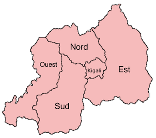
The provinces of Rwanda are divided into districts (akarere) and municipalities (umujyi). Prior to January 1, 2006, Rwanda was composed of 12 provinces. The Rwandan government decided to establish new provinces in an attempt to address issues that arose from the Rwandan genocide. The new provinces were to be "ethnically-diverse administrative areas".

Kibungo is a town and sector in the Republic of Rwanda. It is the political, administrative and commercial capital of Ngoma District. In 1998, Kibungo became the site of at least four of Rwanda's last 22 executions. All of the convicts were executed for crimes related to the 1994 genocide.

Muhanga is a city in Rwanda, in the Muhanga District, in Southern Province. The city is situated 5,945 feet (1,812 m) above sea level.

Eastern Province is the largest, the most populous and the least densely populated of Rwanda's five provinces. It was created in early January 2006 as part of a government decentralization program that re-organized the country's local government structures.

Nyagatare is the largest and second most populous district (akarere) in Rwanda. Located in Eastern Province, Rwanda, it occupies the northeastern extremity of Rwanda. Its capital is Nyagatare City, the former capital of the now defunct Umutara province. Nyagatare District borders Uganda in the North, Tanzania in the East, Gatsibo District of the in the South, and Gicumbi District of the Northern Province in the West. Nyagatare has an area of 1741 km2, what makes it the largest district in Rwanda. With a population of 466,944 in 2012, and 653,861 in 2022, Nyagatare is the second most populated district of Rwanda only after Gasabo District of Kigali City with 879,505 inhabitants. This is a 156% increase from 2002 when the population was only 255,104. This sharp rise in the population is mainly due to the major movement of the population from other parts of the country in search of land.

Gasabo is a district (akarere) in Kigali city, the capital of Rwanda. The headquarter of Gasabo is located in Remera Sector. The district also includes large areas of the city itself, including Kacyiru, Kimironko, Remera, Nyarutarama and Kimihurura.

Kicukiro District is one of the three Districts which constitute the City of Kigali and is situated in the South-East of the City of Kigali. Is a district (akarere) located in Kigali Province, Rwanda. Kicukiro is home to a thriving market, a number of NGOs(Non-Government Organizations) and the Bralirwa Brewery. In addition, it is the headquarters for the Friends Church in Rwanda. Kicukiro District is also home to two major memorial sites associated with the Rwandan genocide. These are the Rebero Genocide Memorial Site where 14,400 victims are buried, and the Nyanza Genocide Memorial Site where 5,000 victims were killed after Belgian soldiers who were serving in the United Nations peacekeeping forces abandoned them.

Nyarugenge is a district (akarere) in Kigali Province, Rwanda. Its heart is the city centre of Kigali, and contains most of the city's businesses.

Rubavu District is one of the seven districts (akarere) in Western Province, Rwanda, with a total surface area of 388.4 km2. Its capital is Gisenyi, a large beach resort and border city. The Rubavu Urban area, which includes Gisenyi, Rugerero and other nearby localities, had a 2012 population of 149,209, the second most populous urban area in Rwanda.

Lyantonde is a town in the southern part of the Central Region of Uganda. It is the main municipal, administrative, and commercial center of Lyantonde District.
Housing Bank of Rwanda (HBR), also known as Rwanda Housing Bank, was a commercial bank in Rwanda. Its name in French is Banque de l'Habitat du Rwanda SA (BHR). The bank was one of the commercial banks licensed by the National Bank of Rwanda, the national banking regulator.

Nyamata is a town and sector in the Bugesera District, southeastern Rwanda. Nyamata literally means 'place of milk' from the two Kinyarwanda words nya- 'of' and amata 'milk'. It is the location of the Nyamata Genocide Memorial, commemorating the Rwandan genocide of 1994.
Nemba is a settlement in Rwanda.
The National Institute of Statistics of Rwanda is a government agency responsible for collecting, analyzing, archiving and disseminating national statistical data, with the objective of aiding the government of Rwanda in making appropriate, timely, evidence-based national decisions.
The following is a timeline of the history of the city of Kigali, Rwanda.
References
- ↑ "2012 Population and Housing Census (Provisional Results) | National Institute of Statistics Rwanda". Archived from the original on 2012-12-06. Retrieved 2012-12-06.
- ↑ "2012 Population and Housing Census (Provisional Results) | National Institute of Statistics Rwanda". Archived from the original on 2012-12-06. Retrieved 2012-12-06.