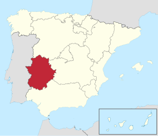
This is a list of Sites of Community Importance in Extremadura .
| ID | Name | Coordinates | Image |
|---|---|---|---|
| ES0000068 | Embalse de Orellana y Sierra de Pela (official name: Embalse de Orellana y Sierra de Pela) Other names: n/a | 39°02′47″N5°21′22″W / 39.0464°N 5.3561°W |  |
| ES0000069 | Embalse de Cornalvo y Sierra Bermeja (official name: Embalse de Cornalvo y Sierra Bermeja) Other names: n/a | 39°02′00″N6°13′28″W / 39.0333°N 6.2244°W |  |
| ES0000070 | Sierra de San Pedro (official name: Sierra de San Pedro) Other names: n/a | 39°19′51″N6°46′41″W / 39.3308°N 6.7781°W |  |
| ES0000072 | Sierra Grande de Hornachos (official name: Sierra Grande de Hornachos) Other names: n/a | 38°34′44″N6°01′55″W / 38.5789°N 6.0319°W |  |
| ES0000369 | Llanos de Alcantara y Brozas (official name: Llanos de Alcantara y Brozas) Other names: n/a | 39°35′22″N6°51′35″W / 39.589444°N 6.8597220000000005°W |  |
| ES4310003 | Complejo Lagunar de la Albuera (official name: Complejo Lagunar de la Albuera) Other names: n/a | 38°41′49″N6°45′48″W / 38.6969°N 6.7633°W | |
| ES4310004 | Dehesas de Jerez (official name: Dehesas de Jerez) Other names: n/a | 38°22′09″N7°02′02″W / 38.369167°N 7.033889°W | |
| ES4310008 | Estena (official name: Estena) Other names: n/a | 39°21′57″N4°46′38″W / 39.365833°N 4.777222°W |  |
| ES4310009 | Puerto Peña - los Golondrinos (official name: Puerto Peña - los Golondrinos) Other names: n/a | 39°14′00″N5°03′44″W / 39.2333°N 5.0622°W | 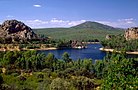 |
| ES4310010 | La Serena (official name: La Serena) Other names: n/a | 38°52′26″N5°23′17″W / 38.873889°N 5.388056°W |  |
| ES4310015 | Río Alcarrache (official name: Río Alcarrache) Other names: n/a | 38°28′09″N6°54′48″W / 38.469167°N 6.9133330000000015°W | |
| ES4310017 | Río Aljucén Bajo (official name: Río Aljucén Bajo) Other names: n/a | 39°00′08″N6°22′37″W / 39.002222°N 6.376944°W |  |
| ES4310019 | Río Ardila Alto (official name: Río Ardila Alto) Other names: n/a | 38°12′24″N6°27′39″W / 38.206667°N 6.460833°W |  |
| ES4310020 | Río Ardila Bajo (official name: Río Ardila Bajo) Other names: n/a | 38°14′23″N6°52′02″W / 38.239722°N 6.867222°W |  |
| ES4310022 | Río Gevora Alto (official name: Río Gevora Alto) Other names: n/a | 39°14′59″N7°07′54″W / 39.249722°N 7.131667°W |  |
| ES4310023 | Río Guadalemar (official name: Río Guadalemar) Other names: n/a | 39°05′12″N4°55′17″W / 39.086667°N 4.921389°W | |
| ES4310024 | Río Guadamez (official name: Río Guadamez) Other names: n/a | 38°40′58″N5°52′13″W / 38.682778000000006°N 5.870278°W |  |
| ES4310026 | Río Guadiana Alto - Zujar (official name: Río Guadiana Alto - Zujar) Other names: n/a | 38°57′30″N5°56′37″W / 38.958333°N 5.943611°W |  |
| ES4310027 | Río Guadiana Internacional (official name: Río Guadiana Internacional) Other names: n/a | 38°48′49″N7°05′50″W / 38.8136°N 7.0972°W |  |
| ES4310028 | Río Matachel (official name: Río Matachel) Other names: n/a | 38°25′28″N5°53′50″W / 38.424444°N 5.897222°W | 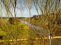 |
| ES4310032 | Rivera de los Limonetes - Nogales (official name: Rivera de los Limonetes - Nogales) Other names: n/a | 38°42′20″N6°46′49″W / 38.7056°N 6.7803°W | |
| ES4310036 | Sierra de Escorial (official name: Sierra de Escorial) Other names: n/a | 39°06′25″N5°06′19″W / 39.106944°N 5.105278°W | |
| ES4310040 | Sierra de Moraleja (official name: Sierra de Moraleja) Other names: n/a | 38°46′40″N5°00′28″W / 38.7778°N 5.0078°W | |
| ES4310042 | Sierra de Siruela (official name: Sierra de Siruela) Other names: n/a | 38°55′40″N5°01′15″W / 38.9278°N 5.0208°W |  |
| ES4310043 | Sierra de Villares - Balbueno (official name: Sierra de Villares - Balbueno) Other names: n/a | 39°04′26″N5°00′21″W / 39.073889°N 5.005833°W | |
| ES4310045 | Valdecigüeñas (official name: Valdecigüeñas) Other names: n/a | 38°03′09″N5°56′53″W / 38.0525°N 5.9480559999999985°W | |
| ES4310048 | Corredor del Lacara (official name: Corredor del Lacara) Other names: n/a | 39°04′03″N6°23′57″W / 39.0675°N 6.3991669999999985°W | |
| ES4310049 | Cueva del Valle de Santa Ana (official name: Cueva del Valle de Santa Ana) Other names: n/a | 38°21′57″N6°47′33″W / 38.365833°N 6.7925°W | |
| ES4310050 | Cuevas de Alconera (official name: Cuevas de Alconera) Other names: n/a | 38°24′25″N6°28′54″W / 38.406944°N 6.481667°W | |
| ES4310055 | Refugio de Sierra Pascuala (official name: Refugio de Sierra Pascuala) Other names: n/a | 38°27′27″N6°32′36″W / 38.4575°N 6.5433330000000005°W | |
| ES4310059 | Río Gevora Bajo (official name: Río Gevora Bajo) Other names: n/a | 38°58′01″N6°56′21″W / 38.966944°N 6.9391669999999985°W |  |
| ES4310060 | Corredores de Siruela (official name: Corredores de Siruela) Other names: n/a | 38°53′15″N4°56′40″W / 38.8875°N 4.944444°W | |
| ES4310061 | Laguna temporal de Murtales (official name: Laguna temporal de Murtales) Other names: n/a | 39°04′08″N6°36′13″W / 39.068889°N 6.603611°W | |
| ES4310062 | Laguna temporal de Tres Arroyos (official name: Laguna temporal de Tres Arroyos) Other names: n/a | 38°50′44″N6°54′28″W / 38.845556°N 6.907778°W | |
| ES4310063 | Río Bembezar (official name: Río Bembezar) Other names: n/a | 38°13′14″N5°37′27″W / 38.220556°N 5.624167°W |  |
| ES4310064 | Río Ortiga (official name: Río Ortiga) Other names: n/a | 38°42′04″N5°42′19″W / 38.701111°N 5.705278°W | |
| ES4310065 | Río Palomillas (official name: Río Palomillas) Other names: n/a | 38°40′35″N6°06′10″W / 38.676389°N 6.102778°W | |
| ES4310066 | Sierra de Maria Andres (official name: Sierra de Maria Andres) Other names: n/a | 38°31′53″N6°39′49″W / 38.531389°N 6.663611°W | |
| ES4310067 | Sierras de Alor y Monte Longo (official name: Sierras de Alor y Monte Longo) Other names: n/a | 38°33′25″N7°03′05″W / 38.556944°N 7.051389°W |  |
| ES4310068 | Sierras de Bienvenida y la Capitana (official name: Sierras de Bienvenida y la Capitana) Other names: n/a | 38°16′13″N6°09′07″W / 38.27027800000001°N 6.151944°W | |
| ES4310069 | Cueva del Agua (official name: Cueva del Agua) Other names: n/a | 38°01′18″N6°29′24″W / 38.021667°N 6.49°W | |
| ES4310070 | Mina las Marias (official name: Mina las Marias) Other names: n/a | 38°29′39″N7°11′49″W / 38.494167°N 7.196944°W | |
| ES4310071 | Mina los Castillejos (official name: Mina los Castillejos) Other names: n/a | 38°27′39″N6°30′00″W / 38.460833°N 6.5°W | |
| ES4310072 | Mina Mariquita (official name: Mina Mariquita) Other names: n/a | 38°21′27″N6°11′09″W / 38.3575°N 6.1858330000000015°W | |
| ES4310073 | Mina los Novilleros (official name: Mina los Novilleros) Other names: n/a | 38°34′48″N7°14′20″W / 38.58°N 7.238889°W | |
| ES4310074 | Arroyos Cabriles y Friegamuñoz (official name: Arroyos Cabriles y Friegamuñoz) Other names: n/a | 38°28′28″N7°13′09″W / 38.4744°N 7.2192°W | |
| ES4310075 | Rivera de Taliga (official name: Rivera de Taliga) Other names: n/a | 38°36′25″N7°14′02″W / 38.6069°N 7.2339°W | |
| ES4320001 | Canchos de Ramiro (official name: Canchos de Ramiro) Other names: n/a | 39°55′27″N6°45′11″W / 39.924167°N 6.753056°W | 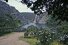 |
| ES4320002 | Cedillo y Río Tajo Internacional (official name: Cedillo y Río Tajo Internacional) Other names: n/a | 39°36′20″N7°14′10″W / 39.605556°N 7.236111°W | |
| ES4320005 | Dehesas del Ruecas y Cubilar (official name: Dehesas del Ruecas y Cubilar) Other names: n/a | 39°12′00″N5°30′25″W / 39.2°N 5.5069°W | |
| ES4320011 | Las Hurdes (official name: Las Hurdes) Other names: n/a | 40°23′49″N6°15′35″W / 40.3969°N 6.2597°W | 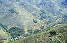 |
| ES4320013 | Granadilla (official name: Granadilla) Other names: n/a | 40°16′32″N6°03′42″W / 40.275556°N 6.061667°W | 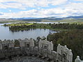 |
| ES4320016 | Río Aljucen Alto (official name: Río Aljucen Alto) Other names: n/a | 39°08′52″N6°11′23″W / 39.147778°N 6.189722°W | |
| ES4320018 | Río Almonte (official name: Río Almonte) Other names: n/a | 39°32′36″N5°58′35″W / 39.5433°N 5.9764°W |  |
| ES4320021 | Río Erjas (official name: Río Erjas) Other names: n/a | 40°01′36″N6°55′06″W / 40.0267°N 6.9183°W |  |
| ES4320029 | Río Ruecas Alto (official name: Río Ruecas Alto) Other names: n/a | 39°22′31″N5°23′29″W / 39.375278°N 5.391389°W | |
| ES4320030 | Río Salor (official name: Río Salor) Other names: n/a | 39°26′36″N6°40′29″W / 39.443333°N 6.674722°W | 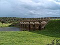 |
| ES4320031 | Tiétar (river) (official name: Río Tiétar) Other names: n/a | 40°02′02″N5°40′42″W / 40.0339°N 5.6783°W |  |
| ES4320033 | Rivera de los Molinos y la Torre (official name: Rivera de los Molinos y la Torre) Other names: n/a | 39°28′53″N6°58′08″W / 39.481389°N 6.968889°W | |
| ES4320035 | Sierra de Cabezas de Aguila (official name: Sierra de Cabezas de Aguila) Other names: n/a | 39°23′48″N5°33′12″W / 39.396667°N 5.553333°W | |
| ES4320037 | Sierra de Gata (official name: Sierra de Gata) Other names: n/a | 40°16′24″N6°38′44″W / 40.273333°N 6.645556°W |  |
| ES4320038 | Sierra de Gredos y Valle del Jerte (official name: Sierra de Gredos y Valle del Jerte) Other names: n/a | 40°11′34″N5°43′16″W / 40.1928°N 5.7211°W |  |
| ES4320039 | Sierra de las Villuercas y Valle del Guadarranque (official name: Sierra de las Villuercas y Valle del Guadarranque) Other names: n/a | 39°33′24″N5°19′14″W / 39.5567°N 5.3206°W |  |
| ES4320046 | Regato Guadalto (official name: Regato Guadalto) Other names: n/a | 39°26′30″N6°51′42″W / 39.441667°N 6.861667°W | |
| ES4320047 | Sierras de Risco Viejo (official name: Sierras de Risco Viejo) Other names: n/a | 40°14′25″N6°19′20″W / 40.2403°N 6.3222°W | |
| ES4320051 | Mina de la Aurora (official name: Mina de la Aurora) Other names: n/a | 40°08′52″N6°41′53″W / 40.147778°N 6.6980559999999985°W | |
| ES4320052 | Mina de la Rivera de Acebo (official name: Mina de la Rivera de Acebo) Other names: n/a | 40°10′11″N6°40′55″W / 40.1697°N 6.6819°W | |
| ES4320057 | Refugio del Alto de San Blas (official name: Refugio del Alto de San Blas) Other names: n/a | 39°20′17″N5°31′09″W / 39.338056°N 5.519167°W | |
| ES4320060 | Arroyos Barbaon y Calzones (official name: Arroyos Barbaon y Calzones) Other names: n/a | 39°56′31″N6°04′09″W / 39.941944°N 6.069167°W | |
| ES4320061 | Arroyos Patana y Regueros (official name: Arroyos Patana y Regueros) Other names: n/a | 40°03′09″N6°33′43″W / 40.0525°N 6.5619°W | |
| ES4320062 | Cañada del Venero (official name: Cañada del Venero) Other names: n/a | 39°55′52″N5°25′44″W / 39.931111°N 5.428889°W | |
| ES4320063 | Embalse Arce de Abajo (official name: Embalse Arce de Abajo) Other names: n/a | 39°35′30″N6°41′12″W / 39.591667°N 6.686667°W | |
| ES4320064 | Embalse de Lancho (official name: Embalse de Lancho) Other names: n/a | 39°28′39″N6°30′38″W / 39.4775°N 6.5105559999999985°W | |
| ES4320065 | Embalse de Petit I (official name: Embalse de Petit I) Other names: n/a | 39°32′24″N6°33′39″W / 39.54°N 6.5608330000000015°W | |
| ES4320066 | Laguna temporal de Corrales (official name: Laguna temporal de Corrales) Other names: n/a | 39°52′41″N6°37′45″W / 39.878056°N 6.629167°W | |
| ES4320067 | Laguna temporal de Valdehornos (official name: Laguna temporal de Valdehornos) Other names: n/a | 40°10′55″N6°36′08″W / 40.181944°N 6.602222°W | |
| ES4320068 | Márgenes de Valdecañas (official name: Márgenes de Valdecañas) Other names: n/a | 39°49′34″N5°21′53″W / 39.8261°N 5.3647°W | |
| ES4320069 | Río Esperaban (official name: Río Esperaban) Other names: n/a | 40°19′52″N6°17′40″W / 40.3311°N 6.2944°W | |
| ES4320070 | Río Guadalupejo (official name: Río Guadalupejo) Other names: n/a | 39°25′40″N5°15′57″W / 39.427778°N 5.265833°W | |
| ES4320071 | Ríos Alagon y Jerte (official name: Ríos Alagon y Jerte) Other names: n/a | 40°04′46″N6°11′00″W / 40.0794°N 6.1833°W |  |
| ES4320072 | Ríos Arrago y Tralgas (official name: Ríos Arrago y Tralgas) Other names: n/a | 40°13′45″N6°29′06″W / 40.2292°N 6.485°W | |
| ES4320073 | Rivera de Aurela (official name: Rivera de Aurela) Other names: n/a | 39°36′04″N7°17′09″W / 39.601111°N 7.285833°W | |
| ES4320074 | Rivera de Membrio (official name: Rivera de Membrio) Other names: n/a | 39°32′55″N7°03′08″W / 39.548611°N 7.052222°W | |
| ES4320075 | Riveras de Carbajo y Calatrucha (official name: Riveras de Carbajo y Calatrucha) Other names: n/a | 39°37′47″N7°08′57″W / 39.629722°N 7.1491669999999985°W | |
| ES4320076 | Riveras de Gata y Acebo (official name: Riveras de Gata y Acebo) Other names: n/a | 40°09′36″N6°39′19″W / 40.16°N 6.6553°W | |
| ES4320077 | Monfragüe (official name: Monfragüe) Other names: n/a | 39°47′47″N5°57′47″W / 39.79638900000001°N 5.963056°W | |
| ES4320078 | Monasterio de Yuste (official name: Monasterio de Yuste) Other names: n/a | 40°06′53″N5°44′10″W / 40.114722°N 5.736111°W | 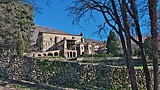 |
| ES4320079 | Mina la Paloma (official name: Mina la Paloma) Other names: n/a | 39°50′26″N6°51′00″W / 39.840556°N 6.85°W | |
| ES4320080 | Tunel de Cañamero (official name: Tunel de Cañamero) Other names: n/a | 39°21′36″N5°24′19″W / 39.36°N 5.405278°W | |