List of landmarks
Individual landmarks
| Landmark Name | Image | Location | Built | Designation date | NRHP date |
|---|---|---|---|---|---|
| Former hardware store [2] |  | 102 S. Linden Street | 1887 | April 15, 1996 | |
| Ecology Action Center [3] |  | 202 W. College Avenue | Circa 1860 | July 19, 1993 | |
| Residence [4] |  | 206 W. Lincoln Street | 1866-1870 | June 15, 1992 | |
| Normal Theater [5] |  | 209 North Street | 1937 | November 4, 1991 | July 25, 1997 |
| Sprague's Super Service [6] |  | 305 E. Pine Street | 1930-1931 | August 15, 2011 | April 25, 2008 |
| John Gregory House [7] |  | 607 N. Main Street | 1860s | April 15, 1991 | |
| Orson Leroy Manchester House [8] |  | 705 S. Broadway Avenue | 1916 | November 20, 1995 | |
| Fairview Sanitorium [9] |  | 905 N. Main Street | 1919 | September 1, 2021 | |
| Residence [10] |  | 905 W. Hovey Avenue | 1900 | May 18, 1998 | |
| Kersey Fell's house [11] | 1202 S. Fell Avenue | 1870 | May 15, 2000 | ||
| Van Leer's Broadview Mansion [12] | 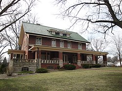 | 1301 S. Fell Avenue | 1906 | August 17, 2015 | |
| Camelback Bridge [13] |  | Constitution Trail | 1870 | April 15, 1991 | May 15, 1997 |
| Cook Hall [14] |  | Illinois State University | 1898 | February 20, 1986 | |
| Fell Park [15] |  |
| mid-1850s | October 20, 2003 |
102 S. Linden Street
This two-story brick building was built in 1887 in Uptown Normal. It served as a hardware store owned by George Champion, an agricultural equipment dealer and mayor of Normal. [2]
202 W. College Avenue, Ecology Action Center
This wooden frame house with Italianate and Greek Revival elements dates to the early 1860s. It was built by Edwin C. Hewitt, one of the first professors at the Normal School. [3]
206 W. Lincoln Street
This Italianate house was built by John R. Gaston between 1866 and 1870. [4]
607 N. Main Street
The John Gregory House is the oldest residence in the Town of Normal. This Italianate-style home was likely built between 1857 and 1870. [7]
705 S. Broadway Avenue
This Queen Anne style house was built in 1916 by Orson Leroy Manchester, a dean at the Illinois State Normal University and mayor of Normal from 1907 to 1917. [8]
1202 S. Fell Avenue
1301 S. Fell Avenue
Fell Park
The land was set aside as a park in the mid-1850s by Jesse Fell and other co-owners. The park officially became a public property in 1898. The town constructed a water tower in the park in 1898 and built brick sidewalks on the park perimeter in the early 1900s. [15]
Historic Districts
Local Historic Districts
- Cedar Crest Historic District [16]
- Highland Historic District [17]
- Old North Normal District [18]