
Administrative division, subnational entity, first-level subdivision, administrative region, constituent unit, as well as many similar terms, are generic names for a discrete, officially delineated geographical area within a particular, independent sovereign state (country). Such a division is created to enhance, in some way, the responsiveness of a national administration (government) to sub-national affairs. As such, an administrative division is granted a certain degree of administrative autonomy, which in some countries is regarded as form of limited self-government.
Due to China's large population and geographical area, the administrative divisions of China have consisted of several levels since ancient era. The constitution of China provides for three de jure levels of government. Currently, however, there are five practical levels of local government: the provincial, prefecture, county, township, and village.

A district is a type of administrative division that, in some countries, is managed by local government. Across the world, areas known as "districts" vary greatly in size, spanning regions or counties, several municipalities, subdivisions of municipalities, school district, or political district.

The Los Angeles Police Department (LAPD), officially the City of Los Angeles Police Department, is the police department of Los Angeles, California. With 9,974 police officers and 3,000 civilian staff, it is the third-largest municipal police department in the United States, after the New York City Police Department and the Chicago Police Department. The department operates in an area of 502.73 square miles (1,302.1 km2) and a population of 3,979,576 people.

The Normandy landings were the landing operations and associated airborne operations on Tuesday, 6 June 1944 of the Allied invasion of Normandy in Operation Overlord during World War II. Codenamed Operation Neptune and often referred to as D-Day, it was the largest seaborne invasion in history. The operation began the liberation of France and laid the foundations of the Allied victory on the Western Front.
A census-designated place (CDP) is a concentration of population defined by the United States Census Bureau for statistical purposes only. CDPs have been used in each decennial census since 1980 as the counterparts of incorporated places, such as self-governing cities, towns, and villages, for the purposes of gathering and correlating statistical data. CDPs are populated areas that generally include one officially designated but currently unincorporated community, for which the CDP is named, plus surrounding inhabited countryside of varying dimensions and, occasionally, other, smaller unincorporated communities as well. CDPs include small rural communities, edge cities, colonias located along the Mexico–United States border, and unincorporated resort and retirement communities and their environs.

Chittagong Division, officially known as Chattogram Division, is geographically the largest of the eight administrative divisions of Bangladesh. It covers the south-easternmost areas of the country, with a total area of 33,771.18 km2 (13,039.13 sq mi) and a population at the 2011 census of 28,423,019. The administrative division includes mainland Chittagong District, neighbouring districts and the Chittagong Hill Tracts.
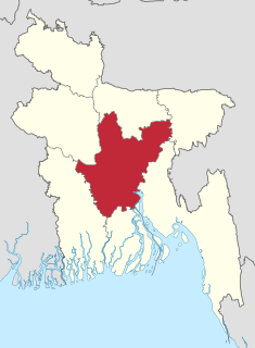
Dhaka Division is an administrative division within Bangladesh. Dhaka is the capital city of Bangladesh and also the largest city as well of the country. It comes among the 10 most populous cities of the world. The Division as constituted prior to 2015 covered an area of 31,051 km2, and had a population of 47,424,418 at the 2011 Census. However, following the separation of the new Mymensingh Division in 2015, the area has been reduced to 20,508.8 km2 with a population at the 2011 Census of 36,433,505.
The English football league system, also known as the football pyramid, is a series of interconnected leagues for men's association football clubs in England, with five teams from Wales, one from Guernsey, one from Jersey and one from the Isle of Man also competing. The system has a hierarchical format with promotion and relegation between leagues at different levels, allowing even the smallest club the theoretical possibility of ultimately rising to the very top of the system. There are more than 140 individual leagues, containing more than 480 divisions.

The census geographic units of Canada are the census subdivisions defined and used by Canada's federal government statistics bureau Statistics Canada to conduct the country's quinquennial census. These areas exist solely for the purposes of statistical analysis and presentation; they have no government of their own. They exist on four levels: the top-level (first-level) divisions are Canada's provinces and territories; these are divided into second-level census divisions, which in turn are divided into third-level census subdivisions and fourth-level dissemination areas.

An autonomous administrative division is a subnational administrative division or internal territory of a sovereign state that has a degree of autonomy — self-governance — under the national government. Autonomous areas are distinct from the constituent units of a federation in that they possess unique powers for their given circumstances. Typically, it is either geographically distinct from the rest of the state or populated by a national minority. Decentralization of self-governing powers and functions to such divisions is a way for a national government to try to increase democratic participation or administrative efficiency or to defuse internal conflicts. States that include autonomous areas may be federacies, federations, or confederations. Autonomous areas can be divided into territorial autonomies, subregional territorial autonomies, and local autonomies.
A ward is a local authority area, typically used for electoral purposes. Wards are usually named after neighbourhoods, thoroughfares, parishes, landmarks, geographical features and in some cases historical figures connected to the area. It is common in the United States for wards to simply be numbered.
The administrative divisions of India are subnational administrative units of India; they compose a nested hierarchy of country subdivisions.
The wards and electoral divisions in the United Kingdom are electoral districts at sub-national level represented by one or more councillors. The ward is the primary unit of English electoral geography for civil parishes and borough and district councils, electoral ward is the unit used by Welsh principal councils, while the electoral division is the unit used by English county councils and some unitary authorities. Each ward/division has an average electorate of about 5,500 people, but ward-population counts can vary substantially. As at the end of 2014 there were 9,456 electoral wards/divisions in the UK.