
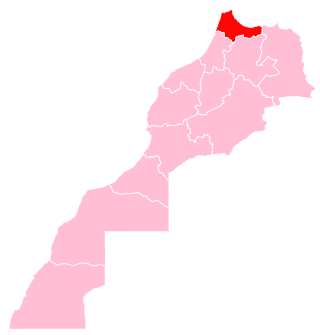
Chefchaouen is a province in the Moroccan economic region of Tanger-Tetouan-Al Hoceima.
Chefchaouen is a province in the Moroccan economic region of Tanger-Tetouan-Al Hoceima.
According to the 2014 national census in Morocco, the province has more than 457,432 inhabitants. The population is 87.45% rural. [1]
The province of Chefchaouen is bordered by five provinces – Tétouan Province to the northwest, Larache Province to the west, Al Hoceïma Province to the east, Taounate Province to the south, Ouezzane Province to the southwest – and the Mediterranean Sea to the northeast. The Province of Chefchaouen belongs to the Tanger-Tetouan-Al Hoceima Region and consists of one urban commune (the municipality of Chefchaouen) and 27 rural communes, giving the province a rural character. [2]
The city of Chefchaouen is the only official municipality in the province, created in 1975. [2] The other major towns are: [3]
This section needs to be updated. The reason given is: These are figures from the 2004 census, please update with figures from the 2014 census. See "Recensement Général de la Population et de l'Habitat de 2014 : Population Légale du Maroc" at this link.(February 2022) |
The province is divided administratively into the following: [4]
| Name | Geographic code | Type | Households | Population (2004) | Foreign population | Moroccan population | Notes |
|---|---|---|---|---|---|---|---|
| Chefchaouen | 151.01.01. | Municipality | 7739 | 35709 | 58 | 35651 | |
| Amtar | 151.03.01. | Rural commune | 1459 | 10038 | 0 | 10038 | |
| Bab Berred | 151.03.03. | Rural commune | 3879 | 23239 | 0 | 23239 | 5043 residents live in the center, called Bab Berred; 18196 residents live in rural areas. |
| Bni Ahmed Cherqia | 151.03.05. | Rural commune | 2021 | 10365 | 1 | 10364 | |
| Bni Ahmed Gharbia | 151.03.07. | Rural commune | 2286 | 12923 | 1 | 12922 | |
| Bni Rzine | 151.03.09. | Rural commune | 2630 | 19585 | 0 | 19585 | |
| Bni Smih | 151.03.11. | Rural commune | 2109 | 15577 | 0 | 15577 | |
| Iounane | 151.03.13. | Rural commune | 3085 | 23132 | 0 | 23132 | |
| Mansoura | 151.03.15. | Rural commune | 2664 | 16559 | 0 | 16559 | |
| M'Tioua | 151.03.17. | Rural commune | 1867 | 12076 | 0 | 12076 | 2984 residents live in the center, called Jebha; 9092 residents live in rural areas. |
| Ouaouzgane | 151.03.19. | Rural commune | 2279 | 16075 | 0 | 16075 | |
| Oued Malha | 151.03.21. | Rural commune | 1974 | 12088 | 0 | 12088 | |
| Tamorot | 151.03.23. | Rural commune | 3581 | 24541 | 0 | 24541 | |
| Bab Taza | 151.05.01. | Rural commune | 4544 | 28549 | 0 | 28549 | 4006 residents live in the center, called Bab Taza; 24543 residents live in rural areas. |
| Bni Darkoul | 151.05.03. | Rural commune | 1888 | 11706 | 0 | 11706 | |
| Bni Faghloum | 151.05.05. | Rural commune | 1603 | 9951 | 0 | 9951 | |
| Bni Salah | 151.05.07. | Rural commune | 1384 | 9662 | 0 | 9662 | |
| Derdara | 151.05.09. | Rural commune | 1644 | 10762 | 0 | 10762 | |
| Fifi | 151.05.11. | Rural commune | 1312 | 7720 | 0 | 7720 | |
| Laghdir | 151.05.13. | Rural commune | 1278 | 7077 | 0 | 7077 | |
| Tanaqoub | 151.05.15. | Rural commune | 1157 | 7219 | 0 | 7219 | |
| Bni Bouzra | 151.07.01. | Rural commune | 2245 | 15254 | 0 | 15254 | |
| Bni Mansour | 151.07.03. | Rural commune | 2468 | 18542 | 0 | 18542 | |
| Bni Selmane | 151.07.05. | Rural commune | 3090 | 23396 | 0 | 23396 | |
| Steha | 151.07.07. | Rural commune | 1695 | 10637 | 0 | 10637 | |
| Talambote | 151.07.09. | Rural commune | 1465 | 10659 | 0 | 10659 | |
| Tassift | 151.07.11. | Rural commune | 1193 | 8139 | 0 | 8139 | |
| Tizgane | 151.07.13. | Rural commune | 1883 | 11711 | 1 | 11710 | |
This section needs additional citations for verification .(November 2023) |
The Chefchaouen Mountains are composed of very rugged siliceous and limestone layers, with some peaks exceeding 2,000 m (6,600 ft) above sea level, such as Jbel Lakraa and Jbel Tissouka in the rural commune of Bab Taza, as well as Jbel Tizirane in the rural commune of Bab Berred.[ citation needed ]
Chefchaouen and its surroundings were historically and geographically known as the Jbala region or country (i.e. mountain inhabitants) where many Jbala tribes once lived. The Jbala region was officially described at the beginning of the 20th century as a geographical territory corresponding to the foothills of the southwestern Rif, between the massifs of the central Rif and the pre-Rif domain. [5] [6]
Natural forests cover around 118,957 hectares (293,950 acres) and are dominated by broad-leaved trees. Forest formations are distributed according to local variations of climate and soil due to altitude, lithology, and human activity. There are sclerophyllous oaks such as cork oak ( Quercus suber ), holm oak ( Quercus rotundifolia ), and kermes oak ( Quercus coccifera ), deciduous oaks such as Tauzin oak ( Quercus pyrenaica ) and zeen oak ( Quercus canariensis and Quercus faginea ), and natural coniferous forests such as Maghreb maritime pine ( Pinus pinaster var. maghrebiana), Moroccan fir (Abies maroccana) and Atlas cedar ( Cedrus atlantica ). [7]
The province of Chefchaouen is considered one of the richest regions in terms of biological diversity.[ clarification needed ] It is designated as a Mediterranean biodiversity hotspot (i.e. a zone with an exceptional concentration of endemic and threatened species) and suffers from accelerated forest degradation due to anthropogenic pressures exacerbated by the impact of climate change. Two protected areas have been created in the province: [8] [9]


In 2006, these two parks were included in the Mediterranean Intercontinental Biosphere Reserve of Spain and Morocco, established in the context of UNESCO's Man and the Biosphere (MAN) program. Reforestation programs have been carried out since 1966, and by 2016 had generated 16,119 ha (39,830 acres). [10]

High rainfall at altitude provides a potential for hydrological development. Several seasonal rivers flow into the Mediterranean or feed the Loukos or Ouargha rivers. [11]

Despite the significant rainfall, agricultural activity is limited due to the rugged and steep topography, the scarcity of arable land, the low mechanization level, and the lack of irrigation infrastructure. These factors have contributed to the emergence of traditional agriculture largely dependent on climatic hazards. Forests have been harvested for wood and pulp products and to clear land for agriculture. Villagers from rural areas form an important workforce in the agricultural field. [12]
The province is dominated by cereal agriculture, goat herding in the mountains, and arboriculture of fig and almond trees. [12] The countryside has a reputation as a prolific source of kief. The Chefchaouen region is one of the main producers of cannabis in Morocco.[ citation needed ]
This traditional agro-pastoral system – of olive and fig plantations, cereal fields, and limited grazing pastures – has been carried out for centuries. Local products are also diversified, such as fresh goat cheese and other animal products, medicinal and aromatic plants, and products based on wild olives, figs, wool, etc. These various agricultural models have contributed to a richness of food diversity and, in 2010, UNESCO recognized Chefchaouen for its Mediterranean diet. [14]
The industrial sector remains very weak despite the province's potential with its availability of human and natural resources. The commercial sector is one of the main economic supports of Chefchaouen, bolstered by tourism activity and remittances from workers abroad. It is mainly focused on urban centers and the main rural communes and is based on the sale of traditional food products, construction materials, clothing, and household items. Commercial transactions become dynamic during summer, with the influx of tourists and the return of foreign workers to the province. [12]

The Rif or Riff, also called Rif Mountains, is a geographic region in northern Morocco. It is bordered on the north by the Mediterranean Sea and Spain and on the west by the Atlantic Ocean, and is the homeland to the indigenous people of the Rifians people. Historically, it belonged to the Rif Republic and its president, Abd el Krim, who led the Rif War from 1920 to 1927 and against a Spanish colonial empire, the Rif region was historically a Spanish colony by the Spanish colonial empire in Africa. This mountainous and fertile area is bordered by Cape Spartel and Tangier to the west, by Berkane and the Moulouya River to the east, by the Mediterranean to the north, and by the Ouergha River to the south. The Rif mountains are separated into the eastern Rif mountains and western Rif mountains.

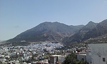
Chefchaouen, also known as Chaouen, is a city in northwest Morocco. It is the chief town of the province of the same name and is noted for its buildings in shades of blue, for which it is nicknamed the "Blue City". It is situated in a mountainous region in northern Morocco, between Tétouan and Ouazzane.

The Jebala are a tribal confederation inhabiting an area in northwest Morocco from the town of Ketema to the west. The Jbala region thus occupies the western part of the Rif mountains. The Jbala has a population of 1,284,000 and is divided into over 40 tribes, today known as "rural communes", and adjacent to them are a small group of nine tribes called the Ghmara (غمارة), who inhabit the territory between the line of mountain peaks to the north of Chefchaouen and the Mediterranean Sea. In addition to tribal heterogeneity, this region is also geographically diverse. High mountains are interspersed with hills and flatlands, and local inhabitants settle in both the high mountains and valleys. In addition to the rainy climate, which influences the way the inhabitants build their houses as well as their special agricultural practices, there are also numerous cultural characteristics that contribute to an emphasised sense of identity and make the Jbala people clearly distinguishable from their neighbours from the eastern part of the Rif Mountains where the climate is more arid, and from the former shepherds from the Atlantic coast (‘Arab). There are only a few cities in the country of the Jbala, and its population remains mostly rural. During the Middle Ages, chroniclers and historians knew the Jbala under their original name, Ghomara.

Jebel Kelti is a mountain in the Tanger-Tetouan-Al Hoceima region, Morocco. It is located south of Tetouan in Chefchaouen Province. This mountain is part of the Rif mountain chain.
Amtar is a small town and rural commune in Chefchaouen Province, Tanger-Tetouan-Al Hoceima, Morocco. At the time of the 2004 census, the commune had a total population of 10,038 people living in 1,459 households. The town's postcode is 91173.
Bni Selmane is a small town and rural commune in Chefchaouen Province, Tanger-Tetouan-Al Hoceima, Morocco. At the time of the 2004 census, the commune had a total population of 23,396 people living in 3090 households.
Iounane is a small town and rural commune in Chefchaouen Province, Tanger-Tetouan-Al Hoceima, Morocco. At the time of the 2004 census, the commune had a total population of 23,132 people living in 3085 households.
Bni Rzine is a small town and rural commune in Chefchaouen Province, Tanger-Tetouan-Al Hoceima, Morocco. At the time of the 2004 census, the commune had a total population of 19,585 people living in 2630 households. Some of the families in Bni Rzine, like Acha(e)ffay, Mesbih, Nassla, Amenchar, Nadi, Ahmadan, Azzouz, Tannan have their roots in the Hoceima/Rif region. Some famous people come from this village, such as Dutch journalist Ikram Akachaou Achaffaye (rip), author Saida Nadi or Khadija Nadi, entrepreneur in the impact field.
Bni Darkoul is a small town and rural commune in Chefchaouen Province, Tanger-Tetouan-Al Hoceima, Morocco. At the time of the 2004 census, the commune had a total population of 11,706 people living in 1888 households.
Bni Faghloum is a small town and rural commune in Chefchaouen Province, Tanger-Tetouan-Al Hoceima, Morocco. At the time of the 2004 census, the commune had a total population of 9951 people living in 1603 households.
Bni Mansour is a small town and rural commune in Chefchaouen Province, Tanger-Tetouan-Al Hoceima, Morocco. At the time of the 2004 census, the commune had a total population of 18,542 people living in 2468 households.
Laghdir is a small town and rural commune in Chefchaouen Province, Tanger-Tetouan-Al Hoceima, Morocco. At the time of the 2004 census, the commune had a total population of 7077 people living in 1278 households.
M'Tioua is a rural commune in Chefchaouen Province, Tanger-Tetouan-Al Hoceima, Morocco. At the time of the 2004 census, the commune had a total population of 12,076 people living in 1867 households.
Oued Malha is a small town and rural commune in Chefchaouen Province, Tanger-Tetouan-Al Hoceima, Morocco. At the time of the 2004 census, the commune had a total population of 12,088 people living in 1974 households.
Tanaqoub is a small town and rural commune in Chefchaouen Province, Tanger-Tetouan-Al Hoceima, Morocco. At the time of the 2004 census, the commune had a total population of 7219 people living in 1157 households.
Tassift is a small town and rural commune in Chefchaouen Province, Tanger-Tetouan-Al Hoceima, Morocco. At the time of the 2004 census, the commune had a total population of 8319 people living in 1193 households.
Tizgane is a small town and rural commune in Chefchaouen Province, Tanger-Tetouan-Al Hoceima, Morocco. At the time of the 2004 census, the commune had a total population of 11,711 people living in 1883 households.
Tangier-Tetouan-Al Hoceima is the northernmost of the twelve regions of Morocco. It covers an area of 15,090 km² and recorded a population of 3,556,729 in the 2014 Moroccan census. The capital of the region is Tangier.

Ouezzane is a province in the Moroccan region of Tanger-Tetouan-Al Hoceima. It was created in 2009 from parts of Chefchaouen Province and Sidi Kacem Province, and recorded a population of 300,637 in the 2014 Moroccan census. The capital is Ouezzane.

M'diq-Fnideq is a prefecture in Tanger-Tetouan-Al Hoceima, Morocco. It covers an area of 178.5 square kilometres (68.9 sq mi) and recorded a population of 209,897 in the 2014 Moroccan census. The seat of the prefecture is M'diq.
| International | |
|---|---|
| National | |
35°10′17″N5°16′11″W / 35.17139°N 5.26972°W