Intercontinental Biosphere Reserve of the Mediterranean

Last updated
Map of the biosphere reserve Reserva de la biosfera intercontinental del Mediterraneo.svg
Map of the biosphere reserve

The Intercontinental Biosphere Reserve of the Mediterranean is the first of its type to be designated by the Man and the Biosphere Programme. It combines the Tingitan Peninsula in Morocco and the southern Iberian Peninsula of Andalusia. Both countries are located in a biogeographic region of deciduous forests and evergreen sclerophyllous scrub within the Mediterranean bioclimatic zone. The maritime area of the biosphere reserve is dominated by the Strait of Gibraltar, which links the two peninsulas. The reserve also encompasses natural and human communication routes between Africa and Europe.

Contents

The Moroccan section of the intercontinental biosphere reserve is located in the region of Djbala on the Tingitan Peninsula, adjacent to the Strait of Gibraltar. It is bordered by the Gharb plain and the hills of Hafs to the west, the Rif Central to the east, the Mediterranean coastline to the north, and the western Prerif to the south. The region is very mountainous and marked by two major crests: the Numidian chain and the mid-ocean limestone ridge. Extensive depressions are found in the crests, including the Chefchaouen furrow, which covers the central portion of the region. The highest peak is Jebel Lakraa with a height of 2,159 metres.

The Spanish section of the biosphere reserve is located in the south of Andalusia. Numerous national parks, such as the Los Alcornocales Natural Park, contribute to the conservation and protection of unique flora and fauna species. In addition, the area is situated on the largest geological massif in Andalusia, the Baetic cordillera. Steep-sloped mountains characterize the topography of the entire area, especially in the north. The highest peak is 1,919 metres and is surrounded by rivers and channels.

The reserve was designated in 2006, and is jointly administered by the Direction regionale des Eaux et forets du Rif, the Consejería de Medio Ambiente of the autonomous community of Andalusia and the Ministerio de Medio Ambiente of Spain.

The reserve covers 894,134.75 hectares. The core areas consist of 86,251.37 hectares (21,651.37 of which are in Spain and 64,600 in Morocco). The buffer areas cover 633,654.95 hectares (351,154.95 in Spain and 282,500 in Morocco). The transition areas cover 174,228.43 hectares (50,728.43 in Spain, 123,500 in Morocco, and a marine area between both countries of 18,854.7 hectares).

Ecological characteristics

Atlantic waters pass through the Strait of Gibraltar, which lies at the heart of the Intercontinental Biosphere Reserve of the Mediterranean. These waters constitute a vital hydrological supplement for the Mediterranean. Without them this inland sea would dry out completely within a 1,000 years.

Morocco’s interior region is mountainous and humid, and has the highest precipitation rate at the national level. The area comprises a variety of habitats with land cover characterized by diverse land uses including pasture, agricultural, livestock, and human settlement.

Cork oak forests and deciduous forests dominate the landscape. Endemic fauna species include Chalcides colosii (Riffian skink), Blanus tingitanus (a reptile of the family Blanidae), and Lacerta pater tangitana. The region is also home to a number of very rare habitats such as bogs with Sphagnum (Peat moss). The Moroccan part of the reserve is home to rare flora species found exclusively in the area of Djebala, including Acer granatense, Alnus glutinousa (Common alder), and Betula celtiberica.

In the Spanish part of the reserve, the Mediterranean climate induces rich vegetation growth, with forest covering more than 60% of the area, of which 49% is dominated by deciduous trees. Species include Quercus canariensis (Algerian oak) and Quercus faginea (Portuguese oak). Abies pinsapo (Spanish fir), Culcita macrocarpa, and Dryopteris guanchica are some of the endangered flora species under strict protection. Many fauna species are also under threat, including Milvus milvus (Red kite), Netta rufina (Red-crested pochard) and Salmo trutta (Brown trout).

The hydrographic network within the territory acts as a closed basin. The majority of the rivers flow in a periodical rhythm and originate from hills in the region. These also form the main source of water supply for the western sector of the province of Cadiz, as well as for the eastern coastal area of the province of Malaga.

Socio-Economic Characteristics

The variety of geological structures in the area have resulted in diverse human interventions. The main economic activities in both the Andalusian and the Moroccan region are agriculture, livestock, and fishery.

With a density of 100 hab/km2, the Moroccan Rif is one of the most densely populated mountain ranges in the Mediterranean. However, geological barriers have limited the accessibility of this marginal area. The population in this part of the reserve is of Arab and Berber origin, with two indigenous peoples dominating the valley of Loukkos – the Berber tribe Ghomara and the Khlot Arabs. Major nomadic tribes include the Bni Hassan and Bni Leit.

The region is also home to an important religious centre renowned throughout North Africa and the Middle East. Thousands of people visit annually to perform a pilgrimage in honour of the Sufi saint, Moulay Abdessalam Ben Mchich. The area is also famous for archaeological and historical sites such as the ancient Phoenician and Roman town, Lixus, near Larache. The area was also under Spanish rule and numerous agricultural products produced today, such as Olea europaea (olive), are of Andalusian origin.

The Andalusian region is adjacent to two other biosphere reserves, namely Sierra de Grazalema and Sierra de las Nieves y su Entorno. The nearest major towns are Cadiz and Malaga.

Ever since the Middle Ages, water has had a crucial meaning for the local population, representing the development and creation of life. Numerous waterfalls, wells and fountains are decorated with statues and engravings linked to the region’s sacred sites.

Several prehistoric findings associated with cave paintings have been recorded at archaeological sites in the reserve. These are commonly found on the terraces of rivers (Palmones and Guadarranque) and in caves (e.g. Cueva de las Palomas and Cueva de la vaca), and are among the most important cultural sites on the Iberian Peninsula. Finally, valuable megalithic monuments, such as dolmens, are distributed throughout the villages of Ronda, Antequera and Aciscar.


Sources

Definition of Free Cultural Works logo notext.svg  This article incorporates text derived from a free content work. License statement/permission . Licensed text taken from UNESCO - MAB Biosphere Reserves Directory , UNESCO, UNESCO. To learn how to add open license text to Wikipedia articles, please see this how-to page. For information on reusing text from Wikipedia, please see Wikipedia's terms of use.

Related Research Articles

Andalusia Autonomous community of Spain

Andalusia is the southernmost autonomous community in Peninsular Spain. It is the most populous and the second largest autonomous community in the country. It is officially recognised as a "historical nationality". The territory is divided into eight provinces: Almería, Cádiz, Córdoba, Granada, Huelva, Jaén, Málaga, and Seville. Its capital city is Seville. The seat of the High Court of Justice of Andalusia is located in the city of Granada.

Jebel Musa (Morocco)

Jebel Musa is a mountain in the northernmost part of Morocco, on the African side of the Strait of Gibraltar. It is part of the Rif mountain chain. The mountain is generally identified as the southern Pillar of Hercules, Abila Mons.

Rif Geographic and cultural region of Morocco

The Rif or Riff, also called Rif Mountains, is a geographic and cultural region in northern Morocco.

Baetic System

The Baetic System or Betic System is one of the main systems of mountain ranges in Spain. Located in the southern and eastern Iberian Peninsula, it is also known as the Cordilleras Béticas or Baetic Mountains. The name of the mountain system derives from the ancient Roman region of Baetica, one of the Imperial Roman provinces of ancient Hispania.

Alboran Sea Westernmost portion of the Mediterranean Sea

The Alboran Sea is the westernmost portion of the Mediterranean Sea, lying between the Iberian Peninsula and the north of Africa. The Strait of Gibraltar, which lies at the west end of the Alboran Sea, connects the Mediterranean with the Atlantic Ocean.

Chefchaouen City in Morocco

Chefchaouen, also known as Chaouen, is a city in northwest Morocco. It is the chief town of the province of the same name, and is noted for its buildings in shades of blue. Chefchaouen is situated just inland from Tangier and Tétouan.

Los Alcornocales Natural Park

Los Alcornocales Natural Park is a natural park located in the south of Spain, in the autonomous community of Andalusia; it is shared between the provinces of Cádiz and Málaga. The natural park occupies a territory spanning seventeen municipalities with a total population of about 380,000. Los Alcornocales means "the cork oak groves".

El Estrecho Natural Park

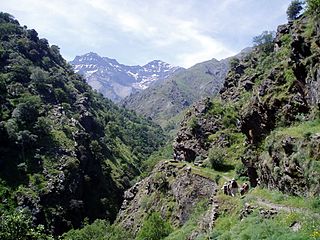
El Estrecho Natural Park is a natural park in Spain, located on the northern side of the Strait of Gibraltar.

Sierras de Cazorla, Segura y Las Villas Natural Park

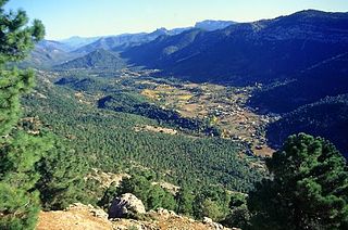
Sierras de Cazorla, Segura y Las Villas Natural Park is a natural park in the eastern and northeastern part of the province of Jaén, Spain, established in 1986. With an area of 2,099.2 square kilometres (810.5 sq mi), it is the largest protected area in Spain and the second largest in Europe. It was declared a biosphere reserve by UNESCO in 1983 and also a Special Protection Area for migratory birds in 1988.

Lago Peñuelas National Reserve

Lago Peñuelas National Reserve is a national reserve of Chile. The reserve was created around Peñuelas Lake, a freshwater reservoir that provides drinking water to Valparaíso and Viña del Mar. The park, which is located in the Valparaíso Region of Chile, was declared a protected area in the year 1952 in order to protect the drainage of the Peñuelas reservoir and dam, built at the end of the 19th and beginning of the Twentieth century. The park, along with La Campana National Park to its north, was designated Campana-Peñuelas Biosphere Reserve by UNESCO in 1984.

Carpathian Biosphere Reserve

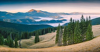
Carpathian Biosphere Reserve is a biosphere reserve that was established as a nature reserve in 1968 and became part of the World Network of Biosphere Reserves of UNESCO in 1992. Since 2007 bigger portion of the reserve along with some territories of the Uzh River National Park was listed with the UNESCO World Heritage Sites as part of the Ancient and Primeval Beech Forests of the Carpathians and Other Regions of Europe.

The Achanakmar-Amarkantak Biosphere Reserve is a biosphere reserve in India that extends across the states of Madhya Pradesh and Chhattisgarh, covering a total area of 383,551 hectares (3835.51 km2).

Talassemtane National Park

Talassemtane National Park is a national park in the Rif region of Northern Morocco. The 589.5-square-kilometre (227.6 sq mi) park was created in October 2004 to conserve the last of Morocco's threatened fir forests.

Waterton Biosphere Reserve UNESCO Biosphere Reserve in Alberta, Canada

Waterton Biosphere Reserve is a UNESCO Biosphere Reserve encompassing Waterton Lakes National Park in the extreme south-west of the Province of Alberta, Canada. The reserve includes a section of the east slopes of the Rocky Mountains extending from the Continental Divide to the edge of the Canadian Great Plains to the east. The Glacier Biosphere Reserve and National Park in Montana, USA is located to the south of the area. The reserve is administered by Waterton Lakes National Park and the Waterton Biosphere Association.

Ciénaga de Zapata Biosphere Reserve

The Ciénaga de Zapata Biosphere Reserve is a UNESCO Biosphere Reserve situated on the southern coast of Cuba at Matanzas province. The 628,171 hectares (2,425.38 sq mi) reserve encompasses the Zapata Swamp and is one of the largest and most important wetlands in the Caribbean region with a marine southern borderline. Ciénaga de Zapata was designated a Ramsar site in 2001. This area is a cluster biosphere reserve with several core areas, highly valuable for conservation located in the Ciénaga de Zapata National Park.

Ría Lagartos Biosphere Reserve

Ría Lagartos Biosphere Reserve is a UNESCO Biosphere Reserve in the state of Yucatán, Mexico. The reserve is located at the eastern end of the coastal strip of the Yucatán Peninsula, with the Gulf of Mexico at its northern limit. The area encompasses coastal areas of the Gulf of Mexico and includes important wetlands designated under the Ramsar Wetlands Convention. The site presents a rich diversity of landscapes and ecosystems, such as mangroves, small estuaries, medium semi-evergreen forest, low deciduous forest, coastal dune vegetation, coastal lagoons, marshes (petenes) and savanna represented by tular vegetation, grasslands and reed beds that are the main nesting sites for marshland and sea birds.

La Encrucijada Biosphere Reserve is a UNESCO Biosphere Reserve situated in the Pacific Coastal Lowlands physiographic region of Mexico. It covers 144,848 hectares (559.26 sq mi) stretching over six municipalities in the Costa de Chiapas. It is composed of two large coastal lagoon systems that correspond to two core areas, and a wide variety of natural ecosystems including mangroves, zapotonales, tule swamps and marshes, as well as patches of tropical seasonal forest, coastal dunes and palm trees.

Sierra de Manantlán Biosphere Reserve

The Sierra de Manantlán Biosphere Reserve is a UNESCO Biosphere Reserve in the states of Colima and Jalisco, Mexico. The 139,577 hectares (538.91 sq mi) reserve is located in the transition of the Nearctic and Neotropical realms and encompasses parts of the Sierra Madre del Sur, with a wide range of altitudes, climates and soils. The effects of tectonic and volcanic activities and erosion are notable within the reserve.

Uzunbodzhak

Uzunbodzhak, also transliterated as Ouzounboudjak is an UNESCO Biosphere Reserve, one of the five nature reserves in Strandzha Nature Park in south-eastern Bulgaria. The reserve is sometimes called Lopushna. Uzunbodzhak was established on 13 December 1956 and was included in the UNESCO network of biosphere reserves in March 1977. It covers an area of 2529.6 hectares, or 25.296 km2. All economic activities are prohibited on the territory of the reserve.

West Polesie Transboundary Biosphere Reserve Nature reserve located in Poland, Ukraine, and Belarus

The West Polesie Transboundary Biosphere Reserve is a transboundary nature reserve located in Poland, Ukraine, and Belarus. It is designated as an area of global importance under UNESCO's World Network of Biosphere Reserves under their Programme on Man and the Biosphere.

References

Coordinates: 35°55′48″N5°35′24″W / 35.9300°N 5.5900°W / 35.9300; -5.5900