Ceuta is an autonomous city of Spain on the north coast of Africa.

Tétouan, also known as Tettawen, is a city in northern Morocco. It lies along the Martil Valley and is one of the two major ports of Morocco on the Mediterranean Sea, a few miles south of the Strait of Gibraltar, and about 60 kilometres (37 mi) E.S.E. of Tangier. In the 2014 Moroccan census, the city recorded a population of 380,787 inhabitants. It is part of the administrative division Tanger-Tetouan-Al Hoceima.

The Spanish protectorate in Morocco was established on 27 November 1912 by a treaty between France and Spain that converted the Spanish sphere of influence in Morocco into a formal protectorate.

The Rif or Riff, also called Rif Mountains, is a geographic region in northern Morocco. It is bordered on the north by the Mediterranean Sea and Spain and on the west by the Atlantic Ocean, and is the homeland to the indigenous people of the Rifians people. Historically, it belonged to the Rif Republic and its president, Abd el Krim, who led the Rif War from 1920 to 1927 and against a Spanish colonial empire, the Rif region was historically a Spanish colony by the Spanish colonial empire in Africa. This mountainous and fertile area is bordered by Cape Spartel and Tangier to the west, by Berkane and the Moulouya River to the east, by the Mediterranean to the north, and by the Ouergha River to the south. The Rif mountains are separated into the eastern Rif mountains and western Rif mountains.

Tangier-Tétouan was formerly one of the sixteen regions of Morocco from 1997 to 2015. It covered an area of 11,570 km² and had a population of 3,157,075. The capital was Tangier. In 2015, Al Hoceïma Province from Taza-Al Hoceima-Taounate was added to it to form the region of Tanger-Tétouan-Al Hoceïma.
The Hispano-Moroccan War, also known as the Spanish–Moroccan War, the First Moroccan War, the Tetuán War, or, in Spain, as the War of Africa, was fought from Spain's declaration of war on Morocco on 22 October 1859 until the Treaty of Wad-Ras on 26 April 1860. It began with a conflict over the borders of the Spanish city of Ceuta and was fought in northern Morocco. Morocco sued for peace after the Spanish victory at the Battle of Tetuán.
Zinat is a village in northern Morocco, situated 50 kilometres east of the city of Tangier, 20 south of the city of Tétouan. It is also home to Ibn Battuta Dam which provides the city of Tangier with drinking water.
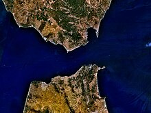
The Bay of Ceuta is a bay on the African coast of the Straits of Gibraltar. It accounts for the majority of the north coast of the Spanish city of Ceuta. It stretches from Punta Blanca in the west to Isla de Santa Catalina, off the coast of the Península de Almina in the east, a distance of eight kilometres. Ceuta's harbour lies on the bay.

Santa Catalina is a small island off the north coast of the Península de Almina in Ceuta, Spain.

The Península de Almina is a peninsula making up much of the eastern part of the Spanish city of Ceuta in Africa. It is dominated by the peak of Monte Hacho. The peninsula contains Ceuta's easternmost point, Punta Almina, and is connected to the rest of Ceuta by an isthmus barely 100 metres (330 ft) in width.

Benzú is a small settlement within the Spanish autonomous city of Ceuta. It has a population of 1,987 according to the 2011 census, divided into two units with Ceuta as its municipality.

The prefecture of Tangier-Asilah is a largely urban subdivision of the Tanger-Tetouan-Al Hoceima region of Morocco. Located in the north of the country, on the Atlantic coast. it had 762,583 inhabitants in 2004 and 1,065,601 inhabitants in 2014.

Morocco–Portugal relations cover a period of several centuries largely historic, and to present not particularly substantial relations. Initial contacts started in the 8th century, when Muslim forces invaded most of the territory of the Iberian peninsula. After the Reconquista, Portugal would then expand into Africa, starting with the territory of Morocco, by invading cities and establishing fortified outposts along the Moroccan coast.
Estadio Alfonso Murube is a football stadium in the autonomous city of Ceuta, Spain in Northern Africa. It is the home stadium of AD Ceuta FC, who currently play in Segunda División B - Group 4, with a capacity of 6,500 seats. The stadium was inaugurated with a match between Ceuta and Algeciras Club de Fútbol, with the home team winning 4–2.

MoroccoandSpain maintain extensive diplomatic, commercial, and military ties. They spanish frontier lies on Melilla and Ceuta, on the Mediterranean coast. Morocco’s foreign policy has focused on Western partners, including neighboring Spain. They have, however, been historically intense and conflictive.
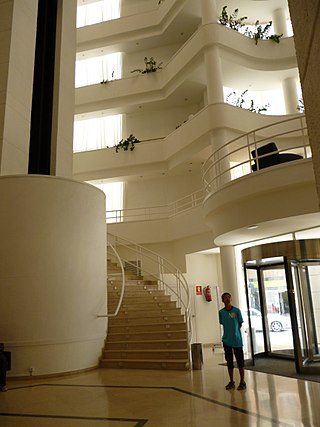
Hotel Ceuta Puerta de Africa is a hotel in Ceuta, a Spanish city bordering northern Morocco. It is located near the Palacio Municipal in the centre of the city, near the corner of Avenida Alcalde Antonio L. Sánchez Prados and the Plaza de África. The hotel has 117 rooms, two suites, a restaurant, bar and conference rooms which accommodate up to 530 people.

The sieges of Ceuta, also known as the thirty-year siege, were a series of blockades by Moroccan forces of the Spanish-held city of Ceuta on the North African coast. The first siege began on 23 October 1694 and finished in 1720 when reinforcements arrived. During the 26 years of the first siege, the city underwent changes leading to the loss of its Portuguese character. While most of the military operations took place around the city walls, there were also small-scale penetrations by Spanish forces at various points on the Moroccan coast, and the seizure of shipping in the Strait of Gibraltar. The city was placed under a second siege in 1721 until 22 April 1727. The engagements are considered to be the longest siege in history.
The following is a timeline of the history of the city of Tangier, Morocco.
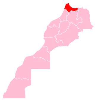
Tangier-Tetouan-Al Hoceima is the northernmost of the twelve regions of Morocco. It covers an area of 15,090 km² and recorded a population of 3,556,729 in the 2014 Moroccan census. The capital of the region is Tangier.

The Royal Palace of Tétouan is a palace of the Moroccan Monarchy in Tétouan, Morocco, and the former main seat of political authority of the Spanish protectorate in Morocco from 1913 to 1956. It encloses both the former governor's palace and the former Spanish consulate, which in the protectorate era respectively housed the Khalifa or personal representative of the Sultan of Morocco on the compound's northwestern side, and the Spanish High Commissioner on its southeastern side. The palace is located on Hassan II Square, a historic urban space also traditionally known as the Feddan, in the Medina of Tétouan.