Corvo

- Beach of Portinho da Areia
The following is a list of the prominent beaches and or tidal swimming areas in the islands of the Azores:


Terceira is a volcanic island in the Azores archipelago, in the middle of the North Atlantic Ocean. It is one of the larger islands of the archipelago, with a population of 53,311 inhabitants in an area of approximately 396.75 square kilometres. It is the location of the Azores' oldest city, Angra do Heroísmo, the historical capital of the archipelago and UNESCO World Heritage Site; the seat of the judicial system ; and the main Air Force base, Base Aérea nº 4 at Lajes, with a United States Air Force detachment.

Praia da Vitória is a municipality in the Portuguese archipelago of the Azores. With a population of 21,035, the second largest administrative authority on the island of Terceira, it covers an area of 161.27 square kilometres (62.27 sq mi), that extends from the northern coast halfway into the interior.
Vila do Porto is the single municipality, the name of the main town and one of the civil parishes on the island of Santa Maria, in the Portuguese archipelago of Azores. Its nearest neighbor, administratively, is the municipality of Povoação on the southern coast of São Miguel, and it is physically southwest of the islets of the Formigas. The population in 2021 was 5,408, in an area of 96.89 km2 (37.41 sq mi).

Angra do Heroísmo, or simply Angra, is a city and municipality on Terceira Island, Portugal, and one of the three capital cities of the Azores. Founded in 1478, Angra was historically the most important city in the Azores, as seat of the Bishop of the Azores, government entities, and having previously served as the capital city of Portugal during the Liberal Wars. The population in 2011 was 35,402, in an area of 239.00 km². It was classified as a World Heritage site by UNESCO in 1983.
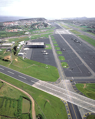
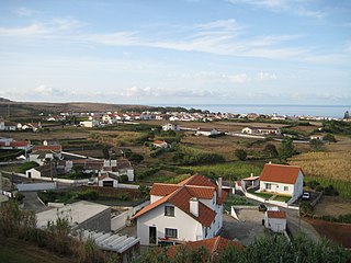
Lajes is a civil parish in the municipality of Praia da Vitória, on the Portuguese island of Terceira in the Azores. The population in 2011 was 3,744, in an area of 12.11 square kilometres (4.68 sq mi). It is the second most populous parish in the municipality of Praia da Vitória. It contains the localities Fundões, Caldeira, Canada da Caldeira, Canada das Fontainhas, Canada das Vinhas, Canada do Poço, Lajedo, Lajes, Picão, Rebentão and Santa Rita.

Ribeira Grande is a municipality in the northern part of the island of São Miguel in the Portuguese Azores. The population in 2011 was 32,112, in an area of 180.15 km2. The municipal seat is located in the civil parish of Matriz, with a population of about 4000 inhabitants, part of the urbanized core of what is commonly referred to as the city of Ribeira Grande.

Povoação is a municipality located in the southeastern corner of the island of São Miguel in the Portuguese archipelago of the Azores. The population in 2011 was 6,327, in an area of 106.41 km².

Almagreira is a civil parish in the municipality of Vila do Porto on the island of Santa Maria, in the Portuguese autonomous region of Azores. The population in 2011 was 599, in an area of 11.22 km². Bordering all other parishes of the island, it is located northwest of Vila do Porto.
The following is a list of notable natural disasters have affected the Azores:
Azores Day is a regional holiday in the Portuguese archipelago of the Azores. It commemorates the establishment of Azorean political autonomy in the Portuguese Constitution, following the Carnation Revolution. The date corresponds to the Festival of the Holy Spirit, a celebration based in the archipelago's religious and cultural history, held on the Sunday of Pentecosts, a movable public holiday observed only in the archipelago of the Azores.

Gaspar de Faria, was the 6th Bishop of Angra, governing the Diocese between 1571 and 1576.
The Fort of the Espírito Santo is the remains of a 16th-century fortification located on the extreme northern edge of the Bay of Praia da Vitória, in the Portuguese civil parish of Santa Cruz, municipality of Praia da Vitória, on the island of Terceira, in the Azores.
A Captaincy-General of the Azores (1766—1832) was a politico-administrative structure of governance imposed in the Azores on 2 August 1766, with its seat in Angra. It remained the de facto system of governance for 65 years, until it was abolished on 4 June 1832 by D. Peter IV, but by 1828 its de jure status had made it nonoperational, owing to the revolutionary movements that lead to the Liberal Wars. The creation of the Captaincy-General was part of the Pombaline reforms to the Portuguese administration, during the reign of Joseph I, under the initiatives of Sebastião José de Carvalho e Melo, 1st Marquis of Pombal, then prime minister. A Captaincy-General operated from the Palace of the Captains-General, under the direction of the titular Captain-General, who operated as the Governor of the Azores, with additional jurisdiction on every island of the Azorean archipelago. The Captaincy-General was succeeded by the Province of the Azores, an ephemeral administrative structure that was collapse in the immediate years.

The Fort of São João Baptista is the ruins of a 16th-century maritime fort situated on the western edge of Praia Formoso, in the civil parish of Almagreira, municipality of Vila do Porto, on the Portuguese island of Santa Maria.