Barge often refers to a flat-bottomed inland waterway vessel which does not have its own means of mechanical propulsion. The first modern barges were pulled by tugs, but on inland waterways, most are pushed by pusher boats, or other vessels. The term barge has a rich history, and therefore there are many other types of barges.

Canals or artificial waterways are waterways or engineered channels built for drainage management or for conveyancing water transport vehicles. They carry free, calm surface flow under atmospheric pressure, and can be thought of as artificial rivers.

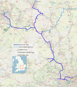
The Grand Union Canal in England is part of the British canal system. It is the principal navigable waterway between London and the Midlands. Starting in London, one arm runs to Leicester and another ends in Birmingham, with the latter stretching for 137 miles (220 km) with 166 locks from London. The Birmingham line has a number of short branches to places including Slough, Aylesbury, Wendover, and Northampton. The Leicester line has two short arms of its own, to Market Harborough and Welford.

British Waterways, often shortened to BW, was a statutory corporation wholly owned by the government of the United Kingdom. It served as the navigation authority for the majority of canals and a number of rivers and docks in England, Scotland and Wales.

Water transport played a vital role in the UK's industrial development. The beginning of the 19th century saw a move from roads to waterways,.

A waterway is any navigable body of water. Broad distinctions are useful to avoid ambiguity, and disambiguation will be of varying importance depending on the nuance of the equivalent word in other ways. A first distinction is necessary between maritime shipping routes and waterways used by inland water craft. Maritime shipping routes cross oceans and seas, and some lakes, where navigability is assumed, and no engineering is required, except to provide the draft for deep-sea shipping to approach seaports (channels), or to provide a short cut across an isthmus; this is the function of ship canals. Dredged channels in the sea are not usually described as waterways. There is an exception to this initial distinction, essentially for legal purposes, see under international waters.

The canal network of the United Kingdom played a vital role in the Industrial Revolution. The UK was the first country to develop a nationwide canal network which, at its peak, expanded to nearly 4,000 miles in length. The canals allowed raw materials to be transported to a place of manufacture, and finished goods to be transported to consumers, more quickly and cheaply than by a land based route. The canal network was extensive and included feats of civil engineering such as the Anderton Boat Lift, the Manchester Ship Canal, the Worsley Navigable Levels and the Pontcysyllte Aqueduct.

The Intracoastal Waterway (ICW) is a 3,000-mile (4,800 km) inland waterway along the Atlantic and Gulf of Mexico coasts of the United States, running from Massachusetts southward along the Atlantic Seaboard and around the southern tip of Florida, then following the Gulf Coast to Brownsville, Texas. Some sections of the waterway consist of natural inlets, saltwater rivers, bays, and sounds, while others are artificial canals. It provides a navigable route along its length without many of the hazards of travel on the open sea.

The Gulf Intracoastal Waterway (GIWW) is the portion of the Intracoastal Waterway located along the Gulf Coast of the United States. It is a navigable inland waterway running approximately 1,300 mi (2,100 km) from Saint Marks, Florida, to Brownsville, Texas.

Regent's Canal is a canal across an area just north of central London, England. It provides a link from the Paddington Arm of the Grand Union Canal, 550 yards (500 m) north-west of Paddington Basin in the west, to the Limehouse Basin and the River Thames in east London. The canal is 8.6 miles (13.8 km) long.

Sabine Lake is a bay on the Gulf coasts of Texas and Louisiana, located approximately 90 miles (140 km) east of Houston and 160 miles (260 km) west of Baton Rouge, adjoining the city of Port Arthur. The lake is formed by the confluence of the Neches and Sabine Rivers and connects to the Gulf of Mexico through Sabine Pass. It forms part of the Texas–Louisiana border, falling within Jefferson and Orange Counties in Texas and Cameron Parish, Louisiana.

The canals of the United Kingdom are a major part of the network of inland waterways in the United Kingdom. They have a varied history, from use for irrigation and transport, through becoming the focus of the Industrial Revolution, to today's role of recreational boating. Despite a period of abandonment, today the canal system in the United Kingdom is again increasing in use, with abandoned and derelict canals being reopened, and the construction of some new routes. Canals in England and Wales are maintained by navigation authorities. The biggest navigation authorities are the Canal & River Trust and the Environment Agency, but other canals are managed by companies, local authorities or charitable trusts.

The Montgomery Canal, known colloquially as "The Monty", is a partially restored canal in eastern Powys and northwest Shropshire. The canal runs 33 miles (53 km) from the Llangollen Canal at Frankton Junction to Newtown via Llanymynech and Welshpool and crosses the England–Wales border.

The Peak Forest Canal is a narrow locked artificial waterway in northern England. It is 14.8 miles (23.8 km) long and forms part of the connected English/Welsh inland waterway network.

The National Waterways Museum (NWM) is in Ellesmere Port, Cheshire, England, at the northern end of the Shropshire Union Canal where it meets the Manchester Ship Canal. The NWM's collections and archives focus on the Britain's navigable inland waterways, including its rivers and canals, and include canal boats, traditional clothing, painted canal decorative ware and tools. It is one of several museums and attractions operated by the Canal & River Trust, the successor to The Waterways Trust.

Inland Waterways Authority of India (IWAI) is the statutory authority in charge of the waterways in India. It was constituted under IWAI Act-1985 by the Parliament of India. Its headquarters is located in Noida, Uttar Pradesh.

This article is a collection of lists of natural and artificial waterways.

The West Coast Canal or National Waterway No 3 is a 205 km (127 mi) long inland navigational route located in Kerala, India, which runs from Kollam to Kottapuram. It was declared a National Waterway in 1993. In addition to the main stretch, Champakara and Udyogmandal canals are navigable and connect the industrial centers of Kochi to Kochi port Inland Waterways Authority of India (IWAI) under the Ministry of Shipping is coordinating the task for developing, monitoring and administering national waterways. It is the first National Waterway in the country with 24-hour navigation facilities along the entire stretch. It has been extended to Kozhikode by the National Waterways Act, 2016. The National Waterway 3 mainly passes through the previous Thiruvananthapuram–Shoranur canal.

The Canal & River Trust (CRT), branded as Glandŵr Cymru in Wales, holds the guardianship of 2,000 miles of canals and rivers, together with reservoirs and a wide range of heritage buildings and structures, in England and Wales. Launched on 12 July 2012, the Trust took over the responsibilities of the state-owned British Waterways in those two places.