List
| Name | Location | Year | Coordinates | Image | Refs |
|---|---|---|---|---|---|
| Antvorskov Church | Antvorskov | 2005 | 55°23′15.61″N11°20′47.65″E / 55.3876694°N 11.3465694°E |  | |
| Boeslunde Church | Boeslunde | c. 1300 | 55°18′5.34″N11°16′15.34″E / 55.3014833°N 11.2709278°E |  | |
| Eggeslevmagle Church | Eggeslevmagle | c. 1100 | 55°17′9.95″N11°20′56.4″E / 55.2860972°N 11.349000°E |  | |
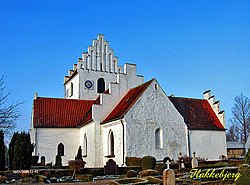
| Flakkebjerg Church | Flakkebjerg |  | |||
| Gerlev Church | Gerlev | c. 1100 | 55°21′9.71″N11°20′16.43″E / 55.3526972°N 11.3378972°E |  | [1] |
| Gimlinge Church | Gimlinge |  | |||
| Gudum Church | Gudum |  | |||
| Halskov Church | Halskov |  | |||
| Havrebjerg Church | Havrebjerg | ||||
| Havrebjerg Valgmenighedskirke | Søbrg |  | |||
| Hejninge Church | Hejninge |  | |||
| Church of the Holy Ghost | Slagelse | c. 1100 | 56°03′51.4″N12°08′27″E / 56.064278°N 12.14083°E |  | [2] |
| Hemmeshøj Church | Hemmeshøj |  | [3] | ||
| Hyllested Church | Hyllested |  | |||
| Høve Church | Høve |  | |||
| Høve Church | Høve |  | |||
| Høve Valgmenighedskirke | Høve |  | |||
| Kindertofte Church | Kindertofte |  | |||
| Kirke Stillinge Church | Kirke Stillinge |  | [4] | ||
| Kirkerup Church | Kirkerup |  | |||
| Lundforlund Church | Lundforlund |  | |||
| Magleby Church | Magleby |  | |||
| St Mikkel's Church | Slagelse | 14th century | 55°24′13.06″N11°21′16.19″E / 55.4036278°N 11.3544972°E |  | [5] |
| St Nicolas' Church | Slagelse | 13th century | 55°15′14.42″N11°17′11.9″E / 55.2540056°N 11.286639°E |  | |
| Nordrupvester Church | Nordtupvester |  | [6] | ||
| Ottestrup New Church | Ottestrup |  | [7] | ||