List of coastal weather stations in the British Isles

Last updated

Reports from these coastal stations and automatic weather logging stations in the British Isles are included in the extended Shipping Forecasts on BBC Radio 4 at 0048 and 0520 local time each day.

Map of sea areas and coastal weather stations referred to in the Shipping Forecast. UK shipping forecast zones.png
Map of sea areas and coastal weather stations referred to in the Shipping Forecast.

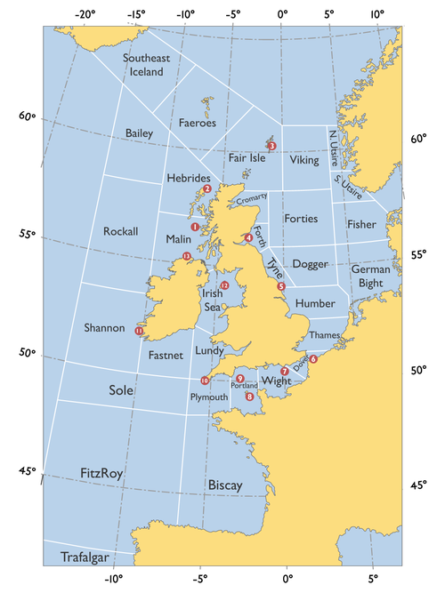
The stations are listed in the order they are read in the forecast, the numbers in brackets refer to the map on the right. Weather reports included in the forecasts are issued at 2300 local time for the late broadcast and 0400 for the early one, although reports issued at other times may be included if for some reason, the most recent weather report did not arrive.

The report from each station is read in the following format: wind direction and speed, visibility in nautical miles, air pressure and pressure trend (steady, rising, or falling with rate of change).

See also

Related Research Articles

<span class="mw-page-title-main">Weather forecasting</span> Science and technology application

Weather forecasting is the application of science and technology to predict the conditions of the atmosphere for a given location and time. People have attempted to predict the weather informally for millennia and formally since the 19th century.

<span class="mw-page-title-main">Beaufort scale</span> Empirical measure describing wind speed based on observed conditions

The Beaufort scale is an empirical measure that relates wind speed to observed conditions at sea or on land. Its full name is the Beaufort wind force scale.

The Shipping Forecast is a BBC Radio broadcast of weather reports and forecasts for the seas around the coasts of the British Isles. It is produced by the Met Office and broadcast by BBC Radio 4 on behalf of the Maritime and Coastguard Agency. The forecast dates back over 150 years. There are currently four broadcasts per day at the following times: 00:48, 05:20, 12:01, and 17:54.

<span class="mw-page-title-main">National Weather Service</span> U.S. forecasting agency of the National Oceanic and Atmospheric Administration

The National Weather Service (NWS) is an agency of the United States federal government that is tasked with providing weather forecasts, warnings of hazardous weather, and other weather-related products to organizations and the public for the purposes of protection, safety, and general information. It is a part of the National Oceanic and Atmospheric Administration (NOAA) branch of the Department of Commerce, and is headquartered in Silver Spring, Maryland, within the Washington metropolitan area. The agency was known as the United States Weather Bureau from 1890 until it adopted its current name in 1970.

<span class="mw-page-title-main">NOAA Weather Radio</span> 24-hour network of VHF FM weather radio stations in the United States

NOAA Weather RadioNWR; also known as NOAA Weather Radio All Hazards is an automated 24-hour network of VHF FM weather radio stations in the United States (U.S.) that broadcast weather information directly from a nearby National Weather Service office. The routine programming cycle includes local or regional weather forecasts, synopsis, climate summaries or zone/lake/coastal waters forecasts. During severe conditions the cycle is shortened into: hazardous weather outlooks, short-term forecasts, special weather statements or tropical weather summaries. It occasionally broadcasts other non-weather related events such as national security statements, natural disaster information, environmental and public safety statements, civil emergencies, fires, evacuation orders, and other hazards sourced from the Federal Communications Commission's (FCC) Emergency Alert System. NOAA Weather Radio uses automated broadcast technology that allows for the recycling of segments featured in one broadcast cycle seamlessly into another and more regular updating of segments to each of the transmitters. It also speeds up the warning transmitting process.

<span class="mw-page-title-main">Met Office</span> United Kingdoms national weather service

The Meteorological Office, abbreviated as the Met Office, is the United Kingdom's national weather service. It is an executive agency and trading fund of the Department for Business, Energy and Industrial Strategy and is led by CEO Penelope Endersby, who took on the role as Chief Executive in December 2018 and is the first woman to do so. The Met Office makes meteorological predictions across all timescales from weather forecasts to climate change.

METAR is a format for reporting weather information. A METAR weather report is predominantly used by aircraft pilots, and by meteorologists, who use aggregated METAR information to assist in weather forecasting.

<span class="mw-page-title-main">Gale warning</span> Weather forecast that includes a warning of a gale and high winds

A gale warning is an alert issued by national weather forecasting agencies around the world in an event that maritime locations currently or imminently experiencing winds of gale force on the Beaufort scale. Gale warnings allow mariners to take precautionary actions to ensure their safety at sea or to seek safe anchorage and ride out the storm on land. Though usually associated with deep low-pressure areas, winds strong enough to catalyze a gale warning can occur in other conditions too, including from anticyclones, or high-pressure systems, in the continental interior. The winds are not directly associated with a tropical cyclone.

<span class="mw-page-title-main">Severe weather terminology (United States)</span> Terminology used by the National Weather Service to describe severe weather in the US

This article describes severe weather terminology used by the National Weather Service (NWS) in the United States. The NWS, a government agency operating as an arm of the National Oceanic and Atmospheric Administration (NOAA) branch of the United States Department of Commerce (DoC), defines precise meanings for nearly all of its weather terms.

SYNOP is a numerical code used for reporting weather observations made by staffed and automated weather stations. SYNOP reports are typically sent every six hours by Deutscher Wetterdienst on shortwave and low frequency using RTTY. A report consists of groups of numbers describing general weather information, such as the temperature, barometric pressure and visibility at a weather station. It can be decoded by open-source software such as seaTTY, metaf2xml or Fldigi.

<span class="mw-page-title-main">Weather radio</span> Specialized radio receiver for weather forecasts

A weather radio is a specialized radio receiver that is designed to receive a public broadcast service, typically from government-owned radio stations, dedicated to broadcasting weather forecasts and reports on a continual basis, with the routine weather reports being interrupted by emergency weather reports whenever needed. Weather radios are typically equipped with a standby alerting function—if the radio is muted or tuned to another band and severe weather bulletin is transmitted, it can automatically sound an alarm and/or switch to a pre-tuned weather channel for emergency weather information. Weather radio services may also occasionally broadcast non-weather-related emergency information, such as in the event of a natural disaster, a child abduction alert, or a terrorist attack.

Sandettie Lightvessel

Sandettie is a lightvessel station located at Sandettie Bank in the North Sea. It is one of the 22 coastal weather stations whose conditions are reported in the BBC Shipping Forecast. The vessel is named after her location on the Sandettie Bank, due north of Calais and due east of the South Foreland. The ship has no engine and is not crewed. Its lights are powered by solar panels.

Channel Lightvessel

Channel was the name of a lightvessel station located in the English Channel between 1979 and August 2021, when it was replaced with a light buoy. It was also one of the 22 coastal weather stations whose conditions were reported in the BBC Shipping Forecast. The vessel's position was 49°55′N2°54′W, approximately 56 km (35 mi) north-northwest of Guernsey.

In broadcasting, local insertion is the act or capability of a broadcast television station, radio station or cable system to insert or replace part of a network feed with content unique to the local station or system. Most often this is a station identification, but is also commonly used for television or radio advertisements, or a weather or traffic report. A digital on-screen graphic, commonly a translucent watermark, may also be keyed (superimposed) with a television station ID over the network feed using a character generator using genlock. In cases where individual broadcast stations carry programs separate from those shown on the main network, this is known as regional variation or an opt-out.

<span class="mw-page-title-main">Automated airport weather station</span> Automated sensor suites

Airport weather stations are automated sensor suites which are designed to serve aviation and meteorological operations, weather forecasting and climatology. Automated airport weather stations have become part of the backbone of weather observing in the United States and Canada and are becoming increasingly more prevalent worldwide due to their efficiency and cost-savings.

<span class="mw-page-title-main">Ocean Prediction Center</span> One of the National Centers for Environmental Predictions service centers

The Ocean Prediction Center (OPC), established in 1995, is one of the National Centers for Environmental Prediction's (NCEP's) original six service centers. Until 2003, the name of the organization was the Marine Prediction Center. Its origins are traced back to the sinking of the RMS Titanic in 1912. The OPC issues forecasts up to five days in advance for ocean areas north of 31° north latitude and west of 35° west longitude in the Atlantic, and across the northeast Pacific north of 30° north latitude and east of 160° east longitude. Until recently, the OPC provided forecast points for tropical cyclones north of 20° north latitude and east of the 60° west longitude to the National Hurricane Center. OPC is composed of two branches: the Ocean Forecast Branch and the Ocean Applications Branch.

<span class="mw-page-title-main">National Weather Service Lincoln, Illinois</span> Forecast office in central Illinois

National Weather Service Lincoln, Illinois also known as National Weather Service Central Illinois is a weather forecast office responsible for monitoring weather conditions for 35 counties in Central and Southeastern Illinois. The Central Illinois office initially consisted of two forecast offices in Peoria and Springfield until the current location in Lincoln became the sole local forecast office in 1995. Federal meteorology offices and stations in the region date back to the 19th century when the Army Signal Service began taking weather observations using weather equipment at the Springer Building in Springfield. Since that time the presence of the National Weather Service greatly increased with the installation of new weather radars, stations and forecast offices. The current office in Lincoln maintains a WSR-88D (NEXRAD) radar system, and Advanced Weather Interactive Processing System (AWIPS) that greatly improve forecasting in the region. Lincoln is in charge of weather forecasts, warnings and local statements as well as aviation weather.

<span class="mw-page-title-main">OpenSeaMap</span>

OpenSeaMap is a software project collecting freely usable nautical information and geospatial data to create a worldwide nautical chart. This chart is available on the OpenSeaMap website, and can also be downloaded for use as an electronic chart for offline applications.

<span class="mw-page-title-main">Regional Meteorological Centre, Chennai</span> Research institute in Chennai

Regional Meteorological Centre, Chennai is one of the six regional meteorological centres (RMCs) of the India Meteorological Department (IMD) and is responsible for the weather-related activities of the southern Indian peninsula comprising the states of Andhra Pradesh, Telangana, Karnataka, Kerala, Tamil Nadu and the union territories of Andaman and Nicobar, Lakshadweep Islands and Puducherry. The other regional centres are located at Kolkata, Guwahati, Mumbai, Nagpur and New Delhi.

<span class="mw-page-title-main">Marine weather forecasting</span> Forecasts of weather conditions at sea

Marine weather forecasting is the process by which mariners and meteorological organizations attempt to forecast future weather conditions over the Earth's oceans. Mariners have had rules of thumb regarding the navigation around tropical cyclones for many years, dividing a storm into halves and sailing through the normally weaker and more navigable half of their circulation. Marine weather forecasts by various weather organizations can be traced back to the sinking of the Royal Charter in 1859 and the RMS Titanic in 1912.

References