Related Research Articles

The Okanagan, also known as the Okanagan Valley and sometimes as the Okanagan Country, is a region in the Canadian province of British Columbia defined by the basin of Okanagan Lake and the Canadian portion of the Okanagan River. It is part of the Okanagan Country, extending into the United States as Okanogan County in north-central Washington. According to the 2016 Canadian census, the region's population is 362,258. The primary city is Kelowna.
Highway 97 is the longest continuously numbered route in the Canadian province of British Columbia, running 2,081 km (1,293 mi) from the Canada–United States border near Osoyoos in the south to the British Columbia/Yukon boundary in the north at Watson Lake, Yukon. The route takes its number from U.S. Route 97, with which it connects at the international border. The highway was initially designated '97' in 1953.
Articles related to British Columbia include:
BC Transit is a provincial crown corporation responsible for coordinating the delivery of public transportation within British Columbia, Canada, outside Greater Vancouver. BC Transit is headquartered in Victoria, British Columbia.
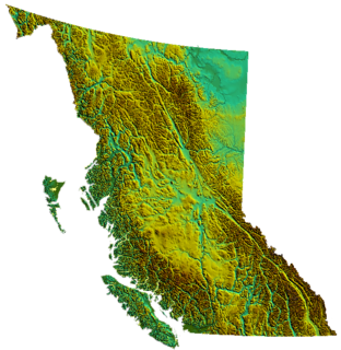
British Columbia is the westernmost province of Canada, bordered by the Pacific Ocean. With an area of 944,735 square kilometres (364,764 sq mi) it is Canada's third-largest province. The province is almost four times the size of United Kingdom and larger than every U.S. state except Alaska. It is bounded on the northwest by the U.S. state of Alaska, directly north by Yukon and the Northwest Territories, on the east by Alberta, and on the south by the U.S. states of Washington, Idaho, and Montana. Formerly part of the British Empire, the southern border of British Columbia was established by the 1846 Oregon Treaty. The province is dominated by mountain ranges, among them the Canadian Rockies but dominantly the Coast Mountains, Cassiar Mountains, and the Columbia Mountains. Most of the population is concentrated on the Pacific coast, notably in the area of Vancouver, located on the southwestern tip of the mainland, which is known as the Lower Mainland. It is the most mountainous province of Canada.

Bute Inlet is one of the principal inlets of the British Columbia Coast. It is 80 km long from the estuaries of the Homathko and Southgate Rivers at the head of the inlet, to the mouth, where it is nearly blocked by Stuart Island, and it averages about 4 km in width. Bute Inlet is in a spectacular wilderness setting and is one of the most scenic waterways in the world. In the upper reaches of the inlet mountains rise 9000 feet above sea level. Bute Inlet is a spectacular wilderness that is visited by very few people. In more recent years tourists are travelling from around the world to view grizzly bears in a natural setting and explore the wilderness of Bute Inlet.
Emergency Support Services (ESS) is a component of the Provincial Emergency Program of the Province of British Columbia. ESS are those services required to preserve the well-being of people affected by an emergency or disaster. Teams are established in local municipalities and assemble together for meetings and contingency planning.
The British Columbia Interior, BC Interior or Interior of British Columbia, usually referred to only as the Interior, is one of the three main regions of the Canadian province of British Columbia, the other two being the Lower Mainland, which comprises the overlapping areas of Greater Vancouver and the Fraser Valley, and the Coast, which includes Vancouver Island and also including the Lower Mainland.
The British Columbia Ministry of Transportation and Infrastructure is the British Columbia government ministry responsible for transport infrastructure and law in the Canadian province of British Columbia. It is currently led by Claire Trevena.

The Robson Valley is a geographic region of the Canadian province of British Columbia, comprising the section of the Rocky Mountain Trench that lies southeast of the city of Prince George following the Fraser River to the Yellowhead Pass. The name is derived from Mount Robson, which stands near the entrance to the Yellowhead Pass. Communities in the Robson Valley include the settlements of Dome Creek, Crescent Spur, Dunster, and Tête Jaune Cache, with larger population concentrations in the villages of McBride and Valemount. On a map, the Robson Valley is located immediately south of the elbow in the boundary between Alberta and British Columbia. Transportation corridors through the Robson Valley include the Canadian National Railway lines, and Highways 16 and 5.
The British Columbia electoral redistribution of 2008 was undertaken over a lengthy period that began in late 2005 and was completed with the passage of the Electoral Districts Act, 2008 on April 10, 2008. The redistribution modified most electoral boundaries in the province, and increased the number of MLAs from 79 to 85. The electoral boundaries created by the redistribution were first used in the 2009 provincial election.
The Thompson Country, also referred to as The Thompson and in some ways as the Thompson Valley and historically known as the Couteau Country or Couteau District, is a historic geographic region of the Southern Interior of British Columbia, more or less defined by the basin of the Thompson River, a tributary of the Fraser and focused on the city of Kamloops.
Rita Winkler is a Canadian Research Hydrologist working at the British Columbia Ministry of Forests, Lands and Natural Resource Operations