Related Research Articles

Nigeria is a federation of 36 states and 1 federal capital territory. Each of the 36 states is a semi-autonomous political unit that shares powers with the Federal Government as enumerated under the Constitution of the Federal Republic of Nigeria. The Federal Capital Territory, also known as FCT, is the capital territory of Nigeria, and it is in this territory that the capital city of Abuja is located. The FCT is not a state but is administered by elected officials who are supervised by the Federal Government. Each state is sub-divided into Local Government Areas (LGAs). There are 774 local government in Nigeria. Under the Constitution, the 36 states are co-equal but not supreme because sovereignty resides with the Federal Government. The constitution can be amended by the National Assembly, but each amendment must be ratified by two-thirds of the 36 states of the federation.
An emirate is a territory ruled by an emir, a title used by monarchs or high officeholders in the Muslim world. There are two emirates that are independent states, and a state that consists of a federation of seven emirates, the United Arab Emirates; the unrecognized Taliban state in Afghanistan is also styled as an emirate. A great number of previously independent emirates around the world are now part of larger states, as can be seen in Nigeria.
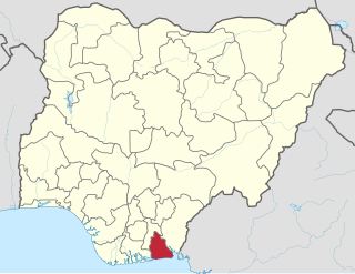
Akwa Ibom State is a state in the South-South geopolitical zone of Nigeria, bordered on the east by Cross River State, on the west by Rivers State and Abia State, and on the south by the Atlantic Ocean. The state takes its name from the Kwa Ibo River which bisects the state before flowing into the Bight of Bonny. Akwa Ibom was split from Cross River State in 1987 with her capital Uyo and with 31 local government areas.

Lagos State is a state in southwestern Nigeria. Of the 36 states, it is both the most populous and smallest in area. Bounded to the south by the Bight of Benin and to the west by the international border with Benin Republic, Lagos State borders Ogun State to the east and north making it the only Nigerian state to border only one other state. Named for the city of Lagos—the most populous city in Africa—the state was formed from the Western Region and the former Federal Capital Territory on 27 May 1967.

Adamawa State is a state in the North-East geopolitical zone of Nigeria, bordered by Borno to the northwest, Gombe to the west, and Taraba to the southwest while its eastern border forms part of the national border with Cameroon. It takes its name from the historic emirate of Adamawa, with the emirate's old capital of Yola serving as the capital city of Adamawa State. The state—one of the most heterogeneous in Nigeria with over 100 indigenous ethnic groups—was formed in 1991 when the former Gongola State was broken up into Adamawa and Taraba states.

Cross River State is a state in the South South geopolitical zone of Nigeria. Named for the Cross River, the state was formed from the eastern part of the Eastern Region on 27 May 1967. Its capital is Calabar, it borders to the north by Benue State, to the west by Ebonyi State and Abia State, and to the southwest by Akwa Ibom State while its eastern border forms part of the national border with Cameroon. Originally known as the South-Eastern State before being renamed in 1976, Cross River State formerly included the area that is now Akwa Ibom State, which became a distinct state in 1987.

Gombe State is a state in northeastern Nigeria, bordered to the north and northeast by the state of Borno and Yobe, to the south by Taraba State, to the southeast by Adamawa State, and to the west by Bauchi State. Named for the city of Gombe—the state's capital and largest city—Gombe State was formed from a part of Bauchi State on 1 October 1996. Of the 36 states of Nigeria, Gombe is the 21st largest in area and 32nd most populous with an estimated population of about 3.25 million as of 2016.
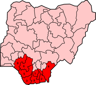
The Niger Delta is the delta of the Niger River sitting directly on the Gulf of Guinea on the Atlantic Ocean in Nigeria. It is typically considered to be located within nine coastal southern Nigerian states, which include: all six states from the South South geopolitical zone, one state (Ondo) from South West geopolitical zone and two states from South East geopolitical zone.

Ebonyi State is a state in the South-East geopolitical zone of Nigeria, bordered to the north and northeast by Benue State, Enugu State to the west, Cross River State to the east and southeast, and Abia State to the southwest. Named for the Abonyi (Aboine) River—a large part of which is in the state's south—Ebonyi State was formed from parts of Abia and Enugu state in 1996 and has its capital as Abakaliki.

Rivers State, also known as Rivers, is a state in the Niger Delta region of southern Nigeria. Formed in 1967, when it was split from the former Eastern Region, Rivers State borders includes; Imo and Abia States to the north, Akwa Ibom State to the east, and Bayelsa and Delta States to the west. The state capital, Port Harcourt, is a metropolis that is considered to be the commercial center of the Nigerian oil industry.

Bauchi State is a state in the North-East geopolitical zone of Nigeria, bordered by Kano and Jigawa to the north, Taraba and Plateau to the south, Gombe and Yobe to the east, and Kaduna to the west. It takes its name from the historic town of Bauchi, which also serves as its capital city. The state was formed in 1976 when the former North-Eastern State was broken up. It originally included the area that is now Gombe State, which became a distinct state in 1996.

Borno State is a state in the North-East geopolitical zone of Nigeria, bordered by Yobe to the west, Gombe to the southwest, and Adamawa to the south while its eastern border forms part of the national border with Cameroon, its northern border forms part of the national border with Niger, and its northeastern border forms all of the national border with Chad, being the only Nigerian state to border three foreign countries. It takes its name from the historic emirate of Borno, with the emirate's old capital of Maiduguri serving as the capital city of Borno State. The state was formed in 1976 when the former North-Eastern State was broken up. It originally included the area that is now Yobe State, which became a distinct state in 1991.

Enugu State is a state in the South-East geopolitical zone of Nigeria, bordered to the north by the states of Benue and Kogi, Ebonyi State to the east and southeast, Abia State to the south, and Anambra State to the west. The state takes its name from its capital and largest city, Enugu.

Northern Nigeria was an autonomous division within Nigeria, distinctly different from the southern part of the country, with independent customs, foreign relations and security structures. In 1962 it acquired the territory of the British Northern Cameroons, which voted to become a province within Northern Nigeria.
The Eastern Region was an administrative region in Nigeria, dating back originally from the division of the colony Southern Nigeria in 1954. Its first capital was Calabar. The capital was later moved to Enugu and the second capital was Umuahia. The region was officially divided in 1967 into three new states, the East-Central State, South-Eastern State. East-Central State had its capital at Enugu, which is now part of Enugu State.

East Central State is a former administrative division of Nigeria. It was created on 27 May 1967 from parts of the Eastern Region and existed until 3 February 1976, when it was divided into two states - Anambra and Imo. The area now comprises five states; Anambra, Imo, Enugu, Ebonyi and Abia. The city of Enugu was the capital of East Central State.
References
- "Provinces and Regions of Nigeria". WorldStatesmen. Retrieved 2010-05-27.