Related Research Articles

Port Pirie is a small city on the east coast of the Spencer Gulf in South Australia, 223 km (139 mi) north of the state capital, Adelaide. Port Pirie is the largest city and the main retail centre of the Mid North region of South Australia. The city has an expansive history which dates back to 1845. Port Pirie was the first proclaimed regional city in South Australia, and is currently the second most important and second busiest port in SA.

Peterborough is a town in the mid north of South Australia, in wheat country, just off the Barrier Highway. It was originally named Petersburg after the landowner, Peter Doecke, who sold land to create the town. It was one of 69 places in South Australia renamed in 1917 due to anti-German sentiments during World War I.

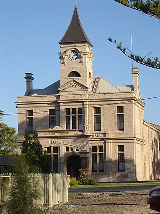
Burra is a pastoral centre and historic tourist town in the mid-north of South Australia. It lies east of the Clare Valley in the Bald Hills range, part of the northern Mount Lofty Ranges, and on Burra Creek. The town began as a single company mining township that, by 1851, was a set of townships collectively known as "The Burra". The Burra mines supplied 89% of South Australia's and 5% of the world's copper for 15 years, and the settlement has been credited with saving the economy of the struggling new colony of South Australia. The Burra Burra Copper Mine was established in 1848 mining the copper deposit discovered in 1845. Miners and townspeople migrated to Burra primarily from Cornwall, Wales, Scotland and Germany. The mine first closed in 1877, briefly opened again early in the 20th century and for a last time from 1970 to 1981.
Wallaroo is a port town on the western side of Yorke Peninsula in South Australia, 160 kilometres (100 mi) northwest of Adelaide. It is one of the three Copper Triangle towns famed for their historic shared copper mining industry, and known together as "Little Cornwall", the other two being Kadina, about 8 kilometres (5 mi) to the east, and Moonta, about 18 kilometres (11 mi) south. In 2016, Wallaroo had a population of 3,988 according to the census held.
Melrose is the oldest town in the Flinders Ranges, South Australia. The town was once named "Mount Remarkable".

Robe is a town and fishing port located in the Limestone Coast of South Australia. The town's distinctive combination of historical buildings, ocean, fishing fleets, lakes and dense bush attracts many tourists. Robe lies on the southern shore of Guichen Bay, just off the Princes Highway. At the 2021 census, Robe had a population of 1252. Robe is the main town in the District Council of Robe local government area. It is in the state electorate of MacKillop and the federal Division of Barker.
Penola is a town in the Australian state of South Australia located about 388 kilometres (241 mi) southeast of the state capital of Adelaide in the wine growing area known as the Coonawarra. At the 2021 Australian Census, the town of Penola had a population of 1,376.

Blinman is a locality incorporating two towns in the Australian state of South Australia within the Flinders Ranges about 425 kilometres (264 mi) north of the state capital of Adelaide. It includes the highest surveyed town in South Australia, with a population in the 2021 census of 43. It serves as a base for large-acre pastoralists and tourism. Blinman is just north of the Flinders Ranges National Park, 60 kilometres north of Wilpena Pound. It is named after Robert Blinman, the shepherd who discovered its mineral resource.

Kingscote is a town in the Australian state of South Australia located on Kangaroo Island about 119 kilometres (74 mi) south-west of the state capital of Adelaide. It is South Australia's oldest European settlement and the island's largest town. At the 2016 census, Kingscote had a population of 1,790. It is a well-established tourist centre and the administrative and communications centre. It is home to a colony of the smallest penguins in the world, the little penguin.

Moonta is a town on the Yorke Peninsula of South Australia, 165 km (103 mi) north-northwest of the state capital of Adelaide. It is one of three towns known as the Copper Coast or "Little Cornwall" for their shared copper mining history.

Palmer is a town just east of the Adelaide Hills region of South Australia along the Adelaide-Mannum Road, 70 kilometres east-north-east of the state capital, Adelaide and 15 km west-north-west of Mannum. It is located in the Mid Murray Council local government area. At the 2006 census, Palmer had a population of 329.

Mile End is an inner western suburb of Adelaide, located in the City of West Torrens, around 2 kilometres from the Adelaide city centre. It has a census area population of 4,413 people (2011). Much of the suburb is residential, but there are small commercial areas along Henley Beach Road and South Road.
Mount Bryan is a town in north-east South Australia. The town is situated on the Barrier Highway and former Peterborough railway line, 20 kilometres (12 mi) north of Burra, in the Regional Council of Goyder.
Yahl is a south-eastern suburb of Mount Gambier

Moonta Mines is a locality at the northern end of the Yorke Peninsula, adjoining the town of Moonta. It is located in the Copper Coast Council. From 1861 to 1923, it was the centre of a copper mining industry that formed colonial South Australia's largest mining enterprise. A substantial portion of the locality is listed on the South Australian Heritage Register as the Moonta Mines State Heritage Area and on the National Heritage List as the Australian Cornish Mining Heritage Site, Moonta Mines.
Yelta is a rural locality at the northern end of the Yorke Peninsula and a satellite village to the town of Moonta, centred on the former Yelta Mine. It is located in the Copper Coast Council. The modern locality was established when the name and boundaries were selected in January 1999.
Whyalla Norrie is a suburb of Whyalla on the Eyre Peninsula of South Australia. It was gazetted as a distinct suburb in 1967, and had its boundaries altered in 1975 and 2000. It is bounded by Iron Knob Road, Norrie Avenue, Broadbent Terrace and MacDouall Stuart Avenue. It is part of the City of Whyalla.
The Corporate Town of Burra was a local government area in South Australia from 1876 to 1969.

Dingley Dell Conservation Park is a protected area in the Australian state of South Australia located in the state's south east in the gazetted locality of Port MacDonnell about 4 kilometres (2.5 mi) north-west of the town centre of Port MacDonnell and about 26 kilometres (16 mi) south of the city centre in Mount Gambier.
References
- ↑ "Royal Exchange Hotel". South Australian Heritage Register. Department of Environment, Water and Natural Resources. Retrieved 9 April 2016.
- ↑ "Former Unicorn Brewery Cellars & Wall". South Australian Heritage Register. Department of Environment, Water and Natural Resources. Retrieved 9 April 2016.
- ↑ "Former Mine Manager's Dwelling and Office". South Australian Heritage Register. Department of Environment, Water and Natural Resources. Retrieved 9 April 2016.
- ↑ "Former Engine/Crusher House". South Australian Heritage Register. Department of Environment, Water and Natural Resources. Retrieved 9 April 2016.
- ↑ "Former Winding House". South Australian Heritage Register. Department of Environment, Water and Natural Resources. Retrieved 9 April 2016.
- ↑ "Former Crusher Chimney [Cornish], Burra Mine Area". South Australian Heritage Register. Department of Environment, Water and Natural Resources. Retrieved 9 April 2016.
- ↑ "Former Graves Pump House". South Australian Heritage Register. Department of Environment, Water and Natural Resources. Retrieved 9 April 2016.
- ↑ "Former Powder Magazine, Burra Mine Area". South Australian Heritage Register. Department of Environment, Water and Natural Resources. Retrieved 9 April 2016.
- ↑ "Former Morphett's Pump House". South Australian Heritage Register. Department of Environment, Water and Natural Resources. Retrieved 9 April 2016.
- ↑ "Former Ore Sorting Floor, Burra Mine Area". South Australian Heritage Register. Department of Environment, Water and Natural Resources. Retrieved 9 April 2016.
- ↑ "Former Haulage Engine Chimney [Welsh], Burra Mine Area". South Australian Heritage Register. Department of Environment, Water and Natural Resources. Retrieved 9 April 2016.
- ↑ "Princess Royal Station (Coach House, Stables & Attached Gate)". South Australian Heritage Register. Department of Environment, Water and Natural Resources. Retrieved 9 April 2016.
- ↑ "Princess Royal Homestead". South Australian Heritage Register. Department of Environment, Water and Natural Resources. Retrieved 9 April 2016.
- ↑ "Dwelling - Barker of Baldina Homes". South Australian Heritage Register. Department of Environment, Water and Natural Resources. Retrieved 9 April 2016.
- ↑ "Dwelling - McBride Cottages". South Australian Heritage Register. Department of Environment, Water and Natural Resources. Retrieved 9 April 2016.
- ↑ "Stone Wall located on south side of Commercial Street and Ware Street". South Australian Heritage Register. Department of Environment, Water and Natural Resources. Retrieved 9 April 2016.
- ↑ "Stone Wall located on north side of Commercial Street". South Australian Heritage Register. Department of Environment, Water and Natural Resources. Retrieved 9 April 2016.
- ↑ "Kooringa Bridge [Bowstring Truss]". South Australian Heritage Register. Department of Environment, Water and Natural Resources. Retrieved 9 April 2016.
- ↑ "Drew & Crewe's Store and Outbuilding". South Australian Heritage Register. Department of Environment, Water and Natural Resources. Retrieved 9 April 2016.
- ↑ "Commercial Hotel". South Australian Heritage Register. Department of Environment, Water and Natural Resources. Retrieved 9 April 2016.
- ↑ "Timber Dwelling of the 1840s". South Australian Heritage Register. Department of Environment, Water and Natural Resources. Retrieved 9 April 2016.
- ↑ "Former Redruth (North Burra) Police Station, Cells and Stables". South Australian Heritage Register. Department of Environment, Water and Natural Resources. Retrieved 9 April 2016.
- ↑ "Dwelling - Part of former home of John and Essington Lewis". South Australian Heritage Register. Department of Environment, Water and Natural Resources. Retrieved 9 April 2016.
- ↑ "Coach House - Part of former home of John and Essington Lewis". South Australian Heritage Register. Department of Environment, Water and Natural Resources. Retrieved 9 April 2016.
- ↑ "Office (former Burra Bible Christian Chapel)". South Australian Heritage Register. Department of Environment, Water and Natural Resources. Retrieved 9 April 2016.
- ↑ "Dwellings (Paxton Square Cottages)". South Australian Heritage Register. Department of Environment, Water and Natural Resources. Retrieved 9 April 2016.
- ↑ "Kooringa Hotel". South Australian Heritage Register. Department of Environment, Water and Natural Resources. Retrieved 9 April 2016.
- ↑ "Former Burra Salvation Army Citadel". South Australian Heritage Register. Department of Environment, Water and Natural Resources. Retrieved 9 April 2016.
- ↑ "Redruth Bridge including Stone Abutments & Walls [Bowstring Truss]". South Australian Heritage Register. Department of Environment, Water and Natural Resources. Retrieved 9 April 2016.
- ↑ "Market Square Rotunda (A Memorial to King Edward VII)". South Australian Heritage Register. Department of Environment, Water and Natural Resources. Retrieved 9 April 2016.
- ↑ "Burra War Memorial". South Australian Heritage Register. Department of Environment, Water and Natural Resources. Retrieved 9 April 2016.
- ↑ "Burra Hotel (previously Miners Arms Hotel)". South Australian Heritage Register. Department of Environment, Water and Natural Resources. Retrieved 9 April 2016.
- ↑ "St Mary's Anglican Church Hall". South Australian Heritage Register. Department of Environment, Water and Natural Resources. Retrieved 9 April 2016.
- ↑ "Peacock's Chimney [Cornish], Burra Mine Area". South Australian Heritage Register. Department of Environment, Water and Natural Resources. Retrieved 9 April 2016.
- ↑ "Burra Mines Historic Site". South Australian Heritage Register. Department of Environment, Water and Natural Resources. Retrieved 9 April 2016.
- ↑ "St Mary's Anglican Church". South Australian Heritage Register. Department of Environment, Water and Natural Resources. Retrieved 9 April 2016.
- ↑ "Former South Australian Mining Association Storeman's Dwelling, Burra Mine Area". South Australian Heritage Register. Department of Environment, Water and Natural Resources. Retrieved 9 April 2016.
- ↑ "Burra Town Hall (incorporating the original Miners' and Mechanics' Institute)". South Australian Heritage Register. Department of Environment, Water and Natural Resources. Retrieved 9 April 2016.
- ↑ "Former South Australian Mining Association Store Room, Yard & Walls, Burra Mine Area". South Australian Heritage Register. Department of Environment, Water and Natural Resources. Retrieved 9 April 2016.
- ↑ "Mine Bridge [Stone Arch] abutments and wall on east side of Market Street". South Australian Heritage Register. Department of Environment, Water and Natural Resources. Retrieved 9 April 2016.
- ↑ "National Australia Bank Burra Agency". South Australian Heritage Register. Department of Environment, Water and Natural Resources. Retrieved 9 April 2016.
- ↑ "Dwelling". South Australian Heritage Register. Department of Environment, Water and Natural Resources. Retrieved 9 April 2016.
- ↑ "Art Gallery (former Burra Post & Telegraph Office)". South Australian Heritage Register. Department of Environment, Water and Natural Resources. Retrieved 9 April 2016.
- ↑ "Dwelling (former Smelter's Home Hotel)". South Australian Heritage Register. Department of Environment, Water and Natural Resources. Retrieved 9 April 2016.
- ↑ "Former Miners' Dugouts, tributary of Burra Creek". South Australian Heritage Register. Department of Environment, Water and Natural Resources. Retrieved 9 April 2016.
- ↑ "Former Dugout Sites, Burra Creek". South Australian Heritage Register. Department of Environment, Water and Natural Resources. Retrieved 9 April 2016.
- ↑ "Burra Railway Station (Station Buildings, Water Columns and Tank)". South Australian Heritage Register. Department of Environment, Water and Natural Resources. Retrieved 9 April 2016.
- ↑ "Former Bon Accord Mine Site (including Mine Buildings, Wall Sections and Slag Heap)". South Australian Heritage Register. Department of Environment, Water and Natural Resources. Retrieved 9 April 2016.
- ↑ "Former Redruth (North Burra) Courthouse". South Australian Heritage Register. Department of Environment, Water and Natural Resources. Retrieved 9 April 2016.
- ↑ "Burra Community School (former Model School)". South Australian Heritage Register. Department of Environment, Water and Natural Resources. Retrieved 9 April 2016.
- ↑ "Former Burra Smelts Historic Site, including Smelts Bridge Abutments, Smelter Ruins, Smelter Furnace Ruins, Smelts Manager's Residence and Office". South Australian Heritage Register. Department of Environment, Water and Natural Resources. Retrieved 9 April 2016.
- ↑ "Former Burra Smeltsyard & Storehouse". South Australian Heritage Register. Department of Environment, Water and Natural Resources. Retrieved 9 April 2016.
- ↑ "Burra Cemetery". South Australian Heritage Register. Department of Environment, Water and Natural Resources. Retrieved 9 April 2016.
- ↑ "Old Koonoona Homestead". South Australian Heritage Register. Department of Environment, Water and Natural Resources. Retrieved 9 April 2016.
- ↑ "Former Smelts Superintendent's Dwelling & Wall". South Australian Heritage Register. Department of Environment, Water and Natural Resources. Retrieved 9 April 2016.
- ↑ "Former Redruth Gaol (sometime Girls Reformatory)". South Australian Heritage Register. Department of Environment, Water and Natural Resources. Retrieved 9 April 2016.
- ↑ "Attached Dwelling ('Tiver's Row')". South Australian Heritage Register. Department of Environment, Water and Natural Resources. Retrieved 9 April 2016.
- ↑ "Attached Dwelling ('Tiver's Row')". South Australian Heritage Register. Department of Environment, Water and Natural Resources. Retrieved 9 April 2016.
- ↑ "Attached Dwelling ('Tiver's Row')". South Australian Heritage Register. Department of Environment, Water and Natural Resources. Retrieved 9 April 2016.
- ↑ "Attached Dwelling ('Tiver's Row')". South Australian Heritage Register. Department of Environment, Water and Natural Resources. Retrieved 9 April 2016.
- ↑ "Attached Dwelling ('Tiver's Row')". South Australian Heritage Register. Department of Environment, Water and Natural Resources. Retrieved 9 April 2016.
- ↑ "Attached Dwelling ('Tiver's Row')". South Australian Heritage Register. Department of Environment, Water and Natural Resources. Retrieved 9 April 2016.
- ↑ "Attached Cottage". South Australian Heritage Register. Department of Environment, Water and Natural Resources. Retrieved 9 April 2016.
- ↑ "Attached Cottage". South Australian Heritage Register. Department of Environment, Water and Natural Resources. Retrieved 9 April 2016.
- ↑ "Attached Cottage". South Australian Heritage Register. Department of Environment, Water and Natural Resources. Retrieved 9 April 2016.
- ↑ "Attached Stone Cottage built for the South Australian Mining Association". South Australian Heritage Register. Department of Environment, Water and Natural Resources. Retrieved 9 April 2016.
- ↑ "Attached Stone Cottage built for the South Australian Mining Association". South Australian Heritage Register. Department of Environment, Water and Natural Resources. Retrieved 9 April 2016.
- ↑ "Dwelling built by the South Australian Mining Association". South Australian Heritage Register. Department of Environment, Water and Natural Resources. Retrieved 9 April 2016.
- ↑ "Dwelling built by the South Australian Mining Association". South Australian Heritage Register. Department of Environment, Water and Natural Resources. Retrieved 9 April 2016.
- ↑ "Dwelling built by the South Australian Mining Association". South Australian Heritage Register. Department of Environment, Water and Natural Resources. Retrieved 9 April 2016.
- ↑ "Dwelling built by the South Australian Mining Association". South Australian Heritage Register. Department of Environment, Water and Natural Resources. Retrieved 9 April 2016.
- ↑ "Dwelling (sometime Masonic Hall, former Burra Primitive Methodist Church)". South Australian Heritage Register. Department of Environment, Water and Natural Resources. Retrieved 9 April 2016.
- ↑ "Dwelling". South Australian Heritage Register. Department of Environment, Water and Natural Resources. Retrieved 9 April 2016.
- ↑ "Dwelling ('Heathmont')". South Australian Heritage Register. Department of Environment, Water and Natural Resources. Retrieved 9 April 2016.
- ↑ "Burra State Heritage Area". South Australian Heritage Register. Department of Environment, Water and Natural Resources. Retrieved 9 April 2016.
- ↑ "Hampton Township Precinct". South Australian Heritage Register. Department of Environment, Water and Natural Resources. Retrieved 9 April 2016.