The following is a list of all state highways in Montgomery County, Texas maintained by the Texas Department of Transportation. All state highways in Texas are paved.
Route Name | Direction | Termini | Junctions | Length [1] | Remarks |
---|---|---|---|---|---|
I-45 [2] | S/N | Harris County to Walker County | SH 242 FM 1488 Loop 336 SH 75 SH 105 FM 830 FM 1097 | 28.0 miles (45.1 km) | Formerly co-signed with US 75 |
I-69 [3] | S/N | Harris County to Liberty County | FM 1314 SH 99 Toll FM 1485 Loop 494 SH 242 FM 2090 | 17.6 miles (28.3 km) | Co-signed with US 59 |
Route Name | Direction | Termini | Junctions | Length [1] | Remarks |
---|---|---|---|---|---|
US 59 [4] | S/N | Harris County to Liberty County | FM 1314 SH 99 Toll FM 1485 Loop 494 SH 242 FM 2090 | 17.6 miles (28.3 km) | Co-signed with I-69 |
Bus. US 59-L [5] | S/N | I-69/US 59 south of Splendora to I-69/US 59 north of Splendora | FM 2090 | 2.3 miles (3.7 km) | Formerly called Loop 512 [5] [6] |
Route Name | Direction | Termini | Junctions | Length [1] | Remarks |
---|---|---|---|---|---|
SH 75 [7] | S/N | I-45/Loop 336 to Walker County | I-45 Loop 336 FM 2854 SH 105 Loop 336 FM 3083 FM 830 FM 2432 FM 1097 | Locally known as Frazier Street in Conroe | |
SH 99 Toll [8] | W/E | Spring Creek at Harris County line to Harris County Line east of Galaxy Boulevard | FM 1314 I-69/US 59 FM 1485 | SH 99 Toll is part of a third freeway grade-loop that is currently under construction around Greater Houston known as the Grand Parkway; segment G from the Harris County line to I-69/US 59 opened in 2016 and uses electronic tolling via TxTag, TollTag or EZ-Tag. | |
SH 105 [9] | W/E | Grimes County to San Jacinto County, and San Jacinto County to Liberty County | FM 1486 FM 149 FM 2854 FM 3083 I-45 SH 75 FM 1314 FM 3083 Loop 336 FM 1485 FM 1484 | Locally known as Davis Street (eastbound) and Phillips Street (westbound) in Conroe | |
SH 242 [10] | W/E | FM 1488 to I-69/US 59 | I-45 FM 1314 FM 1485 | 21.633 miles (34.815 km) | Locally known as College Park Drive west of I-45 and Needham Road east of I-45 to Lexington Drive |
SH 249 [11] | S/N | Harris County to SH 249 Toll/FM 1774 | No major junctions | 3.2 miles (5.1 km) | Locally known as the Tomball Parkway. SH 249 is signed for the frontage roads for the MCTRA 249 Tollway |
SH 249 Toll | S/N | SH 249/MCTRA 249 Tollway/FM 1774 to Grimes County | FM 149 FM 1488 FM 1486 | 12.5 miles (20.1 km) | Locally known as Aggie Expressway |
Route Name | Direction | Termini | Junctions | Length [1] | Remarks |
---|---|---|---|---|---|
SP 149 [12] | S/N | FM 149 to FM 1488 | No major junctions | 1.4 mi (2.3 km) | |
LP 336 [13] | Orbital | SH 105 I-45 SH 75 FM 1484 FM 3083 SH 105 FM 3083 FM 1314 SH 75 I-45 FM 2854 | 17.4 mi (28.1 km) | ||
LP 494 [14] | S/N | Harris County to I-69/US 59 | FM 1314 SH 99 Toll FM 1485 | 9.7 miles (15.6 km) |
Route Name | Direction | Termini | Junctions | Length [1] | Remarks |
---|---|---|---|---|---|
FM 149 [12] | S/N | FM 1774 in Pinehurst to Grimes County | SH 249 Toll FM 1488 Spur 149 SH 105 FM 1097 | Known as Liberty Street in Montgomery | |
FM 830 [15] | W/E | Lake Conroe to SH 75 south of Willis | I-45 | 5.988 miles (9.637 km) | Locally known as Seven Coves Road |
FM 1097 [16] | W/E | CR 3142 (Johnson Road) to Walker County | FM 149 I-45 SH 75 | Known in Willis as West Montgomery Street west of SH 75 and East Stewart Street east of SH 75 | |
FM 1314 [17] | N/S | SH 105 in Conroe to Loop 494 in Porter | Loop 336 SH 242 SH 99 Toll I-69/US 59 | 20.284 miles (32.644 km) | Known as Porter Road inside Loop 336 and Conroe-Porter Road outside of Loop 336 |
FM 1375 [18] | W/E | FM 149 to Walker County | No major junctions | ||
FM 1484 [19] | W/E | Loop 336 to SH 105 | FM 3083 FM 2432 | 13.702 miles (22.051 km) | |
FM 1485 [20] | W/E | SH 105 in Conroe to Harris County | FM 2090 FM 3083 SH 242 I-69/US 59 Loop 494 SH 99 Toll | 23.981 miles (38.594 km) | |
FM 1486 [21] | N/S | FM 1774 in Magnolia to Grimes County | SH 249 Toll SH 105 | ||
FM 1488 [22] | W/E | Walker County to I-45 in Conroe | FM 1774 SH 249 Toll FM 149 Spur 149 FM 2978 SH 242 | Known as Magnolia Parkway | |
FM 1774 [23] | N/S | SH 249 in Pinehurst to Walker County | FM 149 FM 1488 FM 1486 | Known as Magnolia Boulevard south of Magnolia | |
FM 1791 [24] | N/S | FM 149 to Walker County | No major junctions | ||
FM 2090 [25] | W/E | FM 3085 to Liberty County | I-69/US 59 FM 1485 | ||
FM 2432 [26] | N/S | SH 75 to FM 1488 | No major junctions | 5.085 miles (8.184 km) | |
FM 2854 [27] | W/E | SH 105 near Montgomery to SH 75 in Conroe | Loop 336 I-45 | 16.549 miles (26.633 km) | Known as Metcalf Street in Conroe |
FM 2978 [28] | N/S | Harris County to FM 1488 near Egypt | No major junctions | ||
FM 3083 [29] | N/S | SH 105 in Conroe to FM 1485 near Grangerland | I-45 SH 75 FM 1484 Loop 336 SH 105 Loop 336 FM 2090 | 16.653 miles (26.800 km) |
U.S. Route 80 or U.S. Highway 80 (US 80) is a major east-west United States Numbered Highway in the Southern United States, much of which was once part of the early auto trail known as the Dixie Overland Highway. As the "0" in the route number indicates, it was originally a cross-country route, from the Pacific Ocean to the Atlantic Ocean. Its original western terminus was at Historic US 101 in San Diego, California. However, the entire segment west of Dallas, Texas, has been decommissioned in favor of various Interstate Highways and state highways. Currently, the highway's western terminus is at an interchange with Interstate 30 (I-30) on the Dallas–Mesquite, Texas city line. Its eastern terminus is in Tybee Island, Georgia near the Atlantic Ocean. Between Jonesville, Texas and Kewanee, Mississippi, US 80 runs parallel to or concurrently with Interstate 20. It also currently runs through Dallas, Texas; Shreveport, Louisiana; Jackson, Mississippi; Montgomery, Alabama; Columbus, Georgia; Macon, Georgia; and Savannah, Georgia.
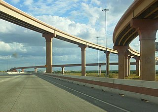
Loop 20, also known as the Bob Bullock Loop and Cuatro Vientos Road, is a highway loop that runs to the north and east of the city of Laredo, Texas. Loop 20 extends from the World Trade International Bridge at its northern point to Mangana-Hein Road at its southern point. The current route varies in construction from a 2-lane road to a freeway with frontage roads.