This article is a list of historic places in Centre-du-Québec, entered on the Canadian Register of Historic Places, whether they are federal, provincial, or municipal. All addresses are the administrative Region 17. For all other listings in the province of Quebec, see List of historic places in Quebec.
| Name | Address | Coordinates | IDF | IDP | IDM | | Image |
|---|---|---|---|---|---|---|---|
| Ancien presbytère de Saint-Edmond-de-Grantham | 1393, Rue Notre-Dame-de-Lourdes, Saint-Edmond-de-Grantham , QC | 45°52′54″N72°40′34″W / 45.8816°N 72.6762°W | 13975 |  | |||
| Église anglicane Saint-Paul | Chemin des Domaines, Saint-Félix-de-Kingsey , QC | 45°47′54″N72°13′28″W / 45.7984°N 72.2244°W | 15339 |  | |||
| Maison d'école du rang Cinq-Chicots | 416, Avenue Pie X, Saint-Christophe-d'Arthabaska , QC | 46°01′49″N71°55′57″W / 46.0303°N 71.9325°W | 4732 |  More images | |||
| Wilfrid Laurier House National Historic Site of Canada | 16 Laurier Street West, Victoriaville , QC | 46°02′16″N71°54′56″W / 46.0379°N 71.9156°W | 9554 | 3611 |  More images | ||
| Maison Marc-Aurèle-De Foy-Suzor-Coté | 846 Boulevard des Bois-Francs Sud, Victoriaville, QC | 46°02′27″N71°55′11″W / 46.0409°N 71.9196°W | 5039 | 8533 |  | ||
| Église de Saint-Christophe | Rue Laurier Ouest, Victoriaville, QC | 46°02′02″N71°54′58″W / 46.0339°N 71.9161°W | 10164 |  More images | |||
| Site du patrimoine de l'Église-Sainte-Victoire | Rue Notre-Dame Ouest, Victoriaville, QC | 46°03′24″N71°57′43″W / 46.0567°N 71.962°W | 10887 |  More images | |||
| Site du patrimoine de l'Église-Saint-Christophe-d'Arthabaska | Rue Laurier Ouest, Victoriaville, QC | 46°02′02″N71°54′58″W / 46.0339°N 71.9161°W | 10888 | More images | |||
| Église de Saint-Cyrille | 4425, Rue Principale, Saint-Cyrille-de-Wendover , QC | 45°56′02″N72°25′26″W / 45.9339°N 72.4238°W | 11203 |  More images | |||
| Presbytère de Saint-Cyrille | 34, Rue Saint-Louis, Saint-Cyrille-de-Wendover, QC | 45°56′02″N72°25′26″W / 45.9338°N 72.424°W | 13632 |  | |||
| Grange-écurie | 4425 Rue Principale, Saint-Cyrille-de-Wendover, QC | 45°56′02″N72°25′24″W / 45.9339°N 72.4232°W | 11206 |  | |||
| Maison du sacristain | 4435 Rue Principale, Saint-Cyrille-de-Wendover, QC | 45°56′03″N72°25′23″W / 45.9341°N 72.4230°W | 13810 |  | |||
| Charnier | 4425, Rue Principale, Saint-Cyrille-de-Wendover, QC | 45°56′02″N72°25′27″W / 45.9339°N 72.4242°W | 16041 |  | |||
| Maison Cormier | 1353, Rue Saint-Calixte, Plessisville , QC | 46°12′57″N71°46′39″W / 46.2158°N 71.7774°W | 8113 |  | |||
| Pont couvert de Warwick | 28, Route Saint-Albert, Warwick , QC | 45°57′22″N72°00′24″W / 45.9562°N 72.0066°W | 11353 |  More images | |||
| Église de Saint-Grégoire-le-Grand | Boulevard de Port-Royal, Bécancour , QC | 46°16′18″N72°30′42″W / 46.2718°N 72.5116°W | 9468 |  More images | |||
| Église de Saint-Édouard | 675, Boulevard Becancour, Bécancour , QC | 46°24′10″N72°16′29″W / 46.4029°N 72.2747°W | 12398 |  | |||
| Moulin Michel | 675, Boulevard Becancour, Bécancour , QC | 46°24′46″N72°14′50″W / 46.4129°N 72.2473°W | 7679 |  More images | |||
| Maison Trent | 875, Chemin de la Riviere-Est, Saint-Charles-de-Drummond , QC | 45°54′36″N72°29′30″W / 45.91°N 72.4917°W | 6675 |  More images | |||
| Maison Joseph-Wilfrid-Faucher | 441, Rue Lindsay, Drummondville , QC | 45°52′49″N72°29′00″W / 45.8804°N 72.4834°W | 6893 |  More images | |||
| Ancien hôpital Sainte-Croix | 255, Rue Brock, Drummondville, QC | 45°53′01″N72°29′15″W / 45.8836°N 72.4875°W | 7021 |  | |||
| Gare C.N. de Drummondville | 263, Rue Lindsay, Drummondville, QC | 45°52′55″N72°29′17″W / 45.8819°N 72.4881°W | 7080 |  More images | |||
| Manufacture Dominion-Silk-Dyeing-and-Printing | 416, Rue Heriot, Drummondville, QC | 45°53′02″N72°28′52″W / 45.8838°N 72.4811°W | 7389 |  | |||
| École Saint-Frédéric | 457, Rue des Ecoles, Drummondville, QC | 45°52′45″N72°29′02″W / 45.8792°N 72.4839°W | 7712 | | |||
| Centrale hydroélectrique Hemming | 1235, Chemin Hemming, Drummondville, QC | 45°53′01″N72°28′52″W / 45.8837°N 72.4811°W | 9461 |  More images | |||
| Carré Celanese | 1, Carre Celanese, Drummondville, QC | 45°52′18″N72°28′43″W / 45.8717°N 72.4786°W | 13129 |  | |||
| Poste de transmission Marconi | 1425, Rue des Trois-Maisons, Drummondville, QC | 45°51′17″N72°28′14″W / 45.8548°N 72.4706°W | 13974 |  | |||
| Maison Joseph-Trefflé-Caya | 209, Rue Brock, Drummondville, QC | 45°53′05″N72°29′23″W / 45.8847°N 72.4896°W | 6867 |  More images | |||
| Maison et écurie William-Mitchell | 131, Rue Saint-Georges, Drummondville, QC | 45°53′11″N72°29′38″W / 45.8864°N 72.4939°W | 6900 |  | |||
| Cinéma Capitol | 253, Rue Lindsay, Drummondville, QC | 45°52′59″N72°29′18″W / 45.8831°N 72.4883°W | 7022 | 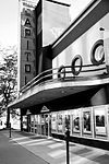 More images | |||
| Centrale hydroélectrique de Drummondville | 25, Rue du Pont, Drummondville, QC | 45°53′10″N72°29′00″W / 45.8862°N 72.4834°W | 7283 |  More images | |||
| Banque de Montréal | 221, Rue Heriot, Drummondville, QC | 45°53′07″N72°29′21″W / 45.8853°N 72.4892°W | 7372 |  | |||
| Pensionnat de Drummondville | 235, Rue Moisan, Drummondville, QC | 45°52′57″N72°29′27″W / 45.8825°N 72.4909°W | 7388 |  | |||
| Église St.George | 276, Rue Heriot, Drummondville, QC | 45°53′03″N72°29′12″W / 45.8843°N 72.4867°W | 7907 |  More images | |||
| Site du patrimoine du Parc-Saint-Frédéric | 219-227, Rue Brock, Drummondville, QC | 45°53′03″N72°29′17″W / 45.8842°N 72.4881°W | 13297 |  More images | |||
| Académie d'Inverness | 330 Chemin Gosford Sud, Inverness, QC | 46°15′33″N71°31′22″W / 46.2591°N 71.5229°W | 11202 |  | |||
| Édifice municipal | 106 Rue Saint-Jean-Baptiste, Saint-Guillaume, QC | 45°52′56″N72°45′58″W / 45.8822°N 72.7662°W | 11991 |  |