For lists of islands of Western Australia, please see:
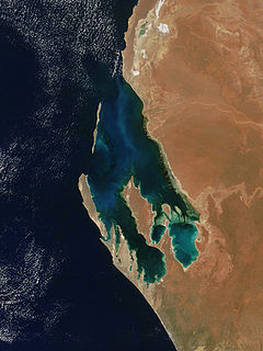
Shark Bay is a World Heritage Site in the Gascoyne region of Western Australia. The 23,000-square-kilometre (8,900 sq mi) area is located approximately 800 kilometres (500 mi) north of Perth, on the westernmost point of the Australian continent. UNESCO's official listing of Shark Bay as a World Heritage Site reads:
Turnagain, also called Buru Island, is an island of the Western Islands region of the Torres Strait Islands archipelago, located in the northern section of Torres Strait, Queensland, Australia. Turnagain is located within the Torres Strait Island Region Local government area.
The Shanks Islands form a group of five small rocky islets located close to the south-western coast of Tasmania, Australia. Situated near where the mouth of Port Davey meets the Southern Ocean, the islets have a combined area of 2.72 hectares and are part of the Swainson Islands Group. They comprise part of the Southwest National Park and the Tasmanian Wilderness World Heritage Site.

The geography of Australia encompasses a wide variety of biogeographic regions being the world's smallest continent, while comprising the territory of the sixth-largest country in the world. The population of Australia is concentrated along the eastern and south-eastern coasts. The geography of the continent is extremely diverse, ranging from the snow-capped mountains of the Australian Alps and Tasmania to large deserts, tropical and temperate forests, grasslands, heathlands and woodlands.
Chicken Island is an island located close to the south-western coast of Tasmania, Australia. The low, flat, 1.95-hectare (0.0075 sq mi) island is part of the Maatsuyker Islands Group, and comprises part of the Southwest National Park and the Tasmanian Wilderness World Heritage Site.

The Western Rocks, also known as Black Rocks, are a pair of islets located close to the south-western coast of Tasmania, Australia. The steep, wave-washed 0.29-hectare (0.0011 sq mi) islets are part of the Maatsuyker Islands Group, and comprises part of the Southwest National Park and the Tasmanian Wilderness World Heritage Site.

Sugarmouse Island is an unpopulated islet located close to the south-western coast of Tasmania, Australia. Situated some 2 kilometres (1.2 mi) south of where the mouth of Port Davey meets the Southern Ocean, the 0.54-hectare (1.3-acre) islet is one of the eight islands that comprise the Mutton Bird Islands Group. Sugarmouse Island is part of the Southwest National Park and the Tasmanian Wilderness World Heritage Site.
The Sugarloaf Rock is a steep, rocky unpopulated islet located close to the south-western coast of Tasmania, Australia. Situated some 2 kilometres (1.2 mi) south of where the mouth of Port Davey meets the Southern Ocean, the 3.56-hectare (8.8-acre) islet is one of the eight islands that comprise the Mutton Bird Islands Group. The Sugarloaf Rock is part of the Southwest National Park and the Tasmanian Wilderness World Heritage Site.
Wendar Island comprises a main unpopulated island and five immediately adjacent islets located close to the south-western coast of Tasmania, Australia. Situated some 2 kilometres (1.2 mi) south of where the mouth of Port Davey meets the Southern Ocean, the 5.8-hectare (14-acre) island and islets are one of the eight islands that comprise the Mutton Bird Islands Group. The Mutton Bird Island is part of the Southwest National Park and the Tasmanian Wilderness World Heritage Site.
The Big Caroline Rock is an unpopulated island located close to the south-western coast of Tasmania, Australia. Situated near where the mouth of Port Davey meets the Southern Ocean, the 2.2-hectare (5.4-acre) island is part of the Swainson Islands Group, and comprises part of the Southwest National Park and the Tasmanian Wilderness World Heritage Site.
Swainson Island is an unpopulated island with an adjacent islet, located close to the south-western coast of Tasmania, Australia. Situated near where the mouth of Port Davey meets the Southern Ocean, the 4.14-hectare (10.2-acre) island is part of the Swainson Islands Group, and comprises part of the Southwest National Park and the Tasmanian Wilderness World Heritage Site.
The Hay Island is an unpopulated island located close to the south-western coast of Tasmania, Australia. Situated near where the mouth of Port Davey meets the Southern Ocean, the 1.85-hectare (4.6-acre) island with an elevation of 78 metres (256 ft) above sea level, is part of the Swainson Islands Group, and comprises part of the Southwest National Park and the Tasmanian Wilderness World Heritage Site.
Lourah Island is an unpopulated island located close to the south-western coast of Tasmania, Australia. Situated within Port Davey, the 4.86-hectare (12.0-acre) island is part of the Swainson Islands Group, and comprises part of the Southwest National Park and the Tasmanian Wilderness World Heritage Site.
The Coffee Pot, also known simply as Coffee Pot, with a shape suggesting a coffee pot, is an unpopulated steep, rocky islet located close to the south-western coast of Tasmania, Australia. It is situated some 2 kilometres (1.2 mi) northwest of where the mouth of Port Davey meets the Southern Ocean, the 0.31-hectare (0.77-acre) islet is part of the Trumpeter Islets Group, and comprises part of the Southwest National Park and the Tasmanian Wilderness World Heritage Site.
West Pyramid is an unpopulated steep-sided island located close to the south-western coast of Tasmania, Australia. Situated some 1 kilometre (0.62 mi) north of the mouth of Port Davey where it meets the Southern Ocean, the 2.5-hectare (6.2-acre) island is part of the Trumpeter Islets Group, and comprises part of the Southwest National Park and the Tasmanian Wilderness World Heritage Site.
Hobbs Island, also known as Green Island, is an unpopulated island located close to the south-western coast of Tasmania, Australia. Situated some 1 kilometre (0.62 mi) north of where the mouth of Port Davey meets the Southern Ocean, the 9.7-hectare (24-acre) island is part of the Trumpeter Islets Group, and comprises part of the Southwest National Park and the Tasmanian Wilderness World Heritage Site.

The Hibbs Pyramid is a pyramidal dolerite island, located in the Indian Ocean, off the south western coast of Tasmania, Australia. The island is contained within the Southwest National Park, part of the Tasmanian Wilderness World Heritage Site.

The continent of Australia is located in the Southern Hemisphere. The continent is sometimes defined as mainland Australia and Tasmania along with smaller surrounding islands. At other times the continent is defined as including the island of New Guinea and its surrounding smaller islands along with Australia.
The Swainson Islands are an unpopulated group of five islands and rocks located off the south western coast of Tasmania, Australia. The 15.76-hectare (38.9-acre) group of islands are situated close to the southern end of the western coast of Tasmania, where the mouth of Port Davey meets the Southern Ocean. The Swainson Islands are part of the Southwest National Park and the Tasmanian Wilderness World Heritage Site.
Little Murray River, an anabranch of the Murray River and part of the Murray–Darling basin, is located in the western Riverina region of south western New South Wales, Australia.