List of legislative routes in Pennsylvania

Last updated

From the 1911 passage of the Sproul Road Bill to the 1987 adoption of the Location Referencing System, all state highways in the U.S. state of Pennsylvania were defined as legislative routes, while some were also posted as Traffic Routes. Major routes were assigned three- or four-digit numbers, while minor routes were given five-digit numbers in which the first two digits represented the county, in alphabetical order from 1 (Adams) to 66 (York). (Philadelphia County was initially skipped, but later assigned the number 67.) State-aid projects, which were carried out even before 1911, received their own permanent numbers - State Aid Application X (SAA X or A-X). Many short routes or realignments were defined as spur or parallel routes to another route.

Contents

Often a route remained on its old alignment, while the signed Traffic Route was moved to a newer bypass with a different number.

1-999

RouteFromToPost-1987 numbersNotes
1Market Street (LR 1/LR 139 - State Route 3012) and Second Street Harrisburg Front Street (LR 1/LR 18 - PA Route 61/PA Route 147) and Market Street (LR 161 - PA Route 61) Sunbury State Route 3012, State Route 3009, U.S. Route 22, PA Route 147
2King Street (LR 2/LR 18 - U.S. Route 11 south/PA Route 147) and Water Street (LR 2 Parallel/LR 18 - U.S. Route 11/PA Route 147) Northumberland Northumberland Street (LR 2/LR 3 - U.S. Route 11) and Mill Street (LR 182 - PA Route 54) Danville U.S. Route 11
3Northumberland Street (LR 2/LR 3 - U.S. Route 11) and Mill Street (LR 182 - PA Route 54) Danville Main Street (LR 3/LR 4/U.S. Route 11) and Market Street Bloomsburg U.S. Route 11
4Main Street (LR 3/LR 4/U.S. Route 11) and Market Street Bloomsburg South Street (LR 4/LR 40036 - State Route 2007) and Washington Street (LR 40036 - State Route 2012) Wilkes-Barre U.S. Route 11, State Route 2005, State Route 2004, State Route 2007
5River Street (LR 5/LR 5 Spur - State Route 2004) and Courtright Avenue (LR 169 - State Route 2009) Wilkes-Barre Blakely Street (LR 5/LR 168 - State Route 2020/State Route 6011) and Green Ridge Street (LR 168 - State Route 6011) Dunmore State Route 2004, U.S. Route 11, State Route 2035, U.S. Route 11, PA Route 307, State Route 6011
6Oak Street (LR 6 - State Route 3033) and Keyser Avenue (LR 671 - State Route 6307) Scranton Main Street (LR 6/LR 7 - U.S. Route 6/PA Route 191) and 9th Street Honesdale State Route 3033, U.S. Route 6
7Main Street (LR 6/LR 7 - U.S. Route 6/PA Route 191) and 9th Street Honesdale Hartford Street (LR 7/LR 167 - U.S. Route 6/U.S. Route 209) and Broad Street (LR 8 - U.S. Route 6/U.S. Route 209) Milford U.S. Route 6
8Broad Street (LR 8 - U.S. Route 6/U.S. Route 209) and Hartford Street (LR 7/LR 167 - U.S. Route 6/U.S. Route 209) Milford Mid-Delaware Bridge (LR 8 - U.S. Route 6/U.S. Route 209) Matamoras U.S. Route 6
9Market Street (LR 9 - State Route 6011) and Main Avenue (LR 168 - State Route 6011) Scranton Church Street (LR 9/LR 14 - PA Route 29 North/PA Route 167/PA Route 706), Main Street (LR 12 - PA Route 29 North) and Public Avenue (LR 57024 - State Route 1043) Montrose State Route 6011, U.S. Route 11, PA Route 706
10 U.S. Route 11 (LR 9/LR 10) and PA Route 706 (LR 9) New Milford Township New York state line (LR 10 - PA Route 92) Oakland Township U.S. Route 11, PA Route 171, PA Route 92
11Market Street (LR 11 - State Route 1006) and Washington Street (LR 40036 - State Route 2012) Wilkes-Barre Bridge Street (LR 11/LR 12 - PA Route 29 North) and Tioga Street (LR 232/LR 241 - U.S. Route 6) Tunkhannock State Route 1009, U.S. Route 11, State Route 1013, PA Route 309, PA Route 29 North
12Bridge Street (LR 11/LR 12 - PA Route 29 North) and Tioga Street (LR 232/LR 241 - U.S. Route 6) Tunkhannock Main Street (LR 12 - PA Route 29 North), Public Avenue (LR 57024 - State Route 1043) and Church Street (LR 9/LR 14 - PA Route 29 North/PA Route 167/PA Route 706) Montrose PA Route 29 North
13 PA Route 87 (LR 13) and U.S. Route 6 (LR 241) Washington Township PA Route 187 (LR 13/LR 15) and U.S. Route 6 (LR 15/LR 241) Wysox Township PA Route 87, State Route 4002, PA Route 187
14Church Street (LR 9/LR 14 - PA Route 29 North/PA Route 167/PA Route 706), Main Street (LR 12 - PA Route 29 North) and Public Avenue (LR 57024 - State Route 1043) Montrose State Route 2010 (LR 14/LR 08010) and PA Route 187 (LR 13) Terry Township PA Route 706, U.S. Route 6, State Route 2010
15Franklin Street (LR 15 - U.S. Route 6) and Main Street (LR 17 - U.S. Route 6/State Route 2027) Towanda New York state line (LR 15 - PA Route 187) Windham Township U.S. Route 6, PA Route 187
16Lightstreet Road (LR 16 - PA Route 487), Main Street (LR 4 - U.S. Route 11) and East Street (LR 4 - U.S. Route 11) Bloomsburg Muncy Street (LR 16/LR 16 Spur E - State Route 3013) and Main Street (LR 17/LR 321 - PA Route 42) Laporte PA Route 487, State Route 4049, State Route 2003. U.S. Route 220, State Route 3013
17Main Street (LR 17/LR 321 - PA Route 42) and Muncy Street (LR 16/LR 16 Spur E - State Route 3013) Laporte Main Street (LR 17/LR 212 - U.S. Route 6) and Bridge Street (LR 08072 - State Route 3018) Towanda PA Route 42, U.S. Route 220, State Route 2027, U.S. Route 6
18Front Street (LR 1/LR 18 - PA Route 61/PA Route 147) and Market Street (LR 161 - PA Route 61) Sunbury Washington Boulevard (LR 18 - State Route 2016) and Market Street (LR 289 - State Route 2023) Williamsport PA Route 147, PA Route 405, PA Route 44, State Route 1007, State Route 2014, State Route 2016
19Water Street (LR 19/LR 240 - PA Route 405) and Main Street (LR 18 - State Route 2014) Muncy Cliff Avenue (LR 17/LR 19 - U.S. Route 220) and Main Street (LR 17 - PA Route 42) Laporte PA Route 405, U.S. Route 220, State Route 3015, U.S. Route 220
20Hepburn Street (LR 20 - State Route 2016) and Market Street (LR 289/LR 41045 - State Route 2023) Williamsport New York state line (LR 20 - PA Route 14) South Creek Township State Route 2016, U.S. Route 15, PA Route 14
21Susquehanna Trail (LR 20 - U.S. Route 15 / PA Route 14) Trout Run Main Street (LR 22 - U.S. Route 6 / PA Route 660 / PA Route 287) Wellsboro U.S. Route 15, U.S. Route 6 / PA Route 660
22Main Street and East Avenue (LR 22/LR 21 Spur - U.S. Route 6 / PA Route 660 / PA Route 287) Wellsboro New York state line U.S. Route 6 / PA Route 287
23 Williamsport Lock Haven
24Susquehanna Trail (LR 25 - U.S. Route 11 / U.S. Route 15) Sunbury LR 26 and LR 176 - PA Route 45 and U.S. Route 15 Lewisburg U.S. Route 11 / U.S. Route 15
25LR 195 - U.S. Route 522 / PA Route 104 Middleburg LR 1 - PA Route 147 Sunbury U.S. Route 522
26LR 28 - U.S. Route 522 / PA Route 104 Middleburg LR 259 - Bridge over Susquehanna, east of LR 24 - U.S. Route 15 Lewisburg PA Route 104 and PA Route 45
27 Winfield Bellefonte
28 Middleburg Lewistown
29 Lewistown Centre Hall
30 Harrisburg Bloomfield
31 Bloomfield Mifflintown
32 Mifflintown Lewistown
33 Lewistown Huntingdon
34 Harrisburg Carlisle
35 Carlisle Chambersburg
36 Chambersburg Maryland state line
37 Chambersburg McConnellsburg
38 McConnellsburg Maryland state line
39 McConnellsburg Bedford
40 Carlisle Bloomfield
41 Carlisle Gettysburg
42 Gettysburg Maryland state line
43 Gettysburg Chambersburg
44 Gettysburg Maryland state line
45 Fort Loudon Mifflintown
46 Everett Huntingdon
47 Bedford Hollidaysburg
48 Bedford Maryland state line
49 Bedford Somerset
50 Somerset Uniontown
51 Berlin Maryland state line
52 Somerset Ebensburg
53 Ebensburg Hollidaysburg
54 Ebensburg Indiana
55 Hollidaysburg Huntingdon
56 Tyrone Pleasant Gap
57 Tyrone Clearfield
58 Bellefonte Lock Haven
59 Clearfield Ridgway
60 DuBois Brookville
61 Brockway Brookville
62 Curwensville Ebensburg
63 Brookville Indiana
64 Brookville Clarion
65 Clarion Franklin
66 Clarion Kittanning
67 Kittanning Indiana
68 Indiana Greensburg
69 Kittanning Greensburg
705th Street (LR 69/LR 70 - PA Route 128 and High Street (LR 69 - PA Route 128) Freeport Western Avenue (LR 70/LR 246 - State Route 4071/State Route 4084) and Allegheny Avenue (LR 246 and LR 652 - State Route 4001) Pittsburgh PA Route 128, PA Route 356, State Route 2019, State Route 1001, PA Route 28, State Route 4084
71 Kittanning Butler
72Main Street (LR 72/LR 73 - PA Route 8/PA Route 356) and Jefferson Street (LR 71 Parallel/LR 73 Parallel - PA Route 68/PA Route 356) Butler Butler Street (LR 70/LR 72 - State Route 1001/State Route 4019) and Freeport Street (LR 70 - State Route 1001) Etna PA Route 8, State Route 1003, State Route 4019
73 Butler Mercer
74 Mercer Ohio state line
75 Butler Van
76Carson Street (LR 76/LR 257 - PA Route 51/PA Route 837) and Main Street (LR 257 - U.S. Route 19 north/PA Route 51 north/PA Route 60 south) Pittsburgh 3rd Street (LR 76/LR 243 - PA Route 68) between Market Street (LR A-892 - State Route 4018) and Commerce Street Beaver PA Route 51, State Route 3109, State Route 3077, State Route 3007, State Route 3002, PA Route 18, State Route 6018, State Route 4042, PA Route 68
77 Beaver New Castle
78 Beaver Butler
79 Butler New Castle
80 New Castle Mercer
81 New Castle Ohio state line
82 Mercer Meadville
83 Conneaut Lake Ohio state line
84 Meadville Erie
85 Meadville West Springfield
86 Ohio state line Erie
87 Erie New York state line
88 Erie Warren
89 Pittsfield Meadville
90 Black Ash Franklin
91 Franklin Tionesta
92 Tionesta Shippenville
93 Tionesta Youngsville
94 Warren New York state line
95 Warren Smethport
96 Smethport New York state line
97 Bradford Ridgway
98 Ridgway Tionesta
99 Ridgway Emporium
100 Emporium Farmers Valley
101 Smethport Coudersport
102 Coudersport Wellsboro
103 Coudersport New York state line
104 Coudersport Forest House
105 Emporium Lock Haven
106 Lock Haven Wellsboro
107
108Noblestown Road (LR 108/LR 257 - PA Route 50/PA Route 60) and Crafton Boulevard (LR 257 - PA Route 60) Pittsburgh College Street (LR 108 - U.S. Route 19) and Maiden Street (LR 113 - U.S. Route 19/U.S. Route 40) Washington PA Route 50, State Route 3003, State Route 1009, PA Route 980, PA Route 519, U.S. Route 19
109 Washington Waynesburg
110 Waynesburg West Virginia state line
111 Waynesburg West Virginia state line
112 Waynesburg Uniontown
113 Uniontown Washington
114 Washington West Virginia state line
115 Washington Beaver
116 Uniontown West Virginia state line
117 Uniontown Greensburg
118 Greensburg Washington
119 Greensburg Bedford
120 Greensburg Pittsburgh
136 Maryland state lineKing Street (LR 142 - PA 462) and Prince Street (LR 136/138 - U.S. Route 222 / PA 272) Lancaster U.S. Route 222 / PA 72
138King Street (LR 142 - PA 462) and Prince Street (LR 136/138 - U.S. Route 222 / PA 272) Lancaster Cornwall Road (LR 137 - PA 72 / U.S. Route 322) Cornwall U.S. Route 222 / PA 72 / PA 272, U.S. Route 322 / PA 72
139Front Street and Market StreetHarrisburg9th Street (PA 72) and Cumberland Street/Benjamin Franklin Highway (US 422) Lebanon [1] [2]
139 SpurState StreetHarrisburgSouth 40th Street at Paxton StreetHarrisburg [3]
140HarrisburgLebanon US 22
140A Paxtonia Linglestown PA 39
442Prince Street (LR 136/138 - US 222 / PA 272) Lancaster Lakes to Sea Highway (LR 137 - US 322) and Furnace Hills Pike (A-7069 - PA 501) Brickerville US 222, PA 501

1000-9999

RouteFromToPost-1987 numbersNotes
1000 Philadelphia Interstate 295 (LR 1000/LR 1020) and Taylorsville Road (LR 09025 - State Route 2071) Lower Makefield Township Interstate 295
1001 Interstate 81 (LR 790/LR 1001) South Abington Township New York state line (LR 1001 - Interstate 81) Great Bend Township Interstate 81
1002 Interstate 84/Interstate 380 (LR 168/LR 1002) and PA Route 435 (LR 168) Dunmore Interstate 80 (LR 794/LR 1002) and PA Route 611 (LR 168) Stroud Township Interstate 84, Interstate 380, Interstate 80
1003 Interstate 79 (LR 1003/LR 1017) and Interstate 90 (LR 797) McKean Township Interstate 79 (LR 1003) and 12th Street (LR 25029 - PA Route 5) Erie Interstate 79
1004
1005 Interstate 81 (LR 799/LR 1005) and U.S. Route 11 (LR 34) Middlesex Township Interstate 81 (LR 790/LR 1005) and Interstate 84/Interstate 380 (LR 790) Dunmore Interstate 81
1006
1007 PA Route 378 (LR 297/LR 1007) and Bridge Street (LR 297 - offramp) Bethlehem PA Route 378 (LR 1007) and U.S. Route 22 (LR 772) Bethlehem PA Route 378
1008
1009
1010
1011
1012
1013
1014
1015
1016
1017
1018
1019
1020 Interstate 295 (LR 1000/LR 1020) and Taylorsville Road (LR 09025 - State Route 2071) Lower Makefield Township Scudder Falls Bridge (LR 1020 - Interstate 295) Lower Makefield Township Interstate 295
1141 Newtown Bypass (LR 1141/LR 09047 - PA Route 413) and Swamp Road (LR 09047 - State Route 2036) Newtown Township Newtown Bypass (LR 1141 - PA Route 332) and Newtown Yardley Road (LR 252 - PA Route 332) Newtown Township PA Route 413, PA Route 332

See also

Related Research Articles

<span class="mw-page-title-main">Pennsylvania Route 39</span> State highway in Dauphin County, Pennsylvania, United States

Pennsylvania Route 39 (PA 39) is a 17.83-mile-long (28.69 km) state highway located in Dauphin County, Pennsylvania, United States. PA 39 runs from North Front Street near Harrisburg east to U.S. Route 322 (US 322) and US 422 near Hummelstown and Hershey. The route passes through the northern and eastern suburbs of Harrisburg and passes by Hersheypark, Giant Center, as well as the primary production factory for The Hershey Company. Between Harrisburg and Manada Hill, it is known as Linglestown Road, from Manada Hill to Hershey as Hershey Road and from Hershey to near Hummelstown and Hershey as Hersheypark Drive. Prior to the establishment of PA 39 in 1937, PA 39, had previously been designated as a route in northeastern Pennsylvania during the 1920s. That designation was deleted when it was renumbered US 11. As a result, PA 39 is one of a few routes which has a set of child routes which are no where near the primary route.

<span class="mw-page-title-main">Pennsylvania Route 25</span> State highway in Pennsylvania, US

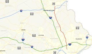
Pennsylvania Route 25 is a 35-mile-long (56 km) state highway located in Dauphin and Schuylkill counties in central Pennsylvania. The western terminus of the route is at U.S. Route 209 in Millersburg. The eastern terminus is at US 209 in Newtown. PA 25 runs parallel to the Mahantongo Mountains and the Mahantango Valley, as well as US 209, for its entire length. The route passes through the communities of Berrysburg, Gratz, Sacramento, and Hegins. PA 25 intersects PA 225 in Berrysburg, PA 125 in Hegins, and Interstate 81 (I-81) in Frailey Township. PA 25 was designated in 1928 to run from US 209 in Millersburg east to PA 443 in Pine Grove, running east to Hegins before heading southeast to Tremont and south to Pine Grove. The road between Hegins and Newtown was designated as PA 125. PA 25 was realigned to head east from Hegins to Newtown in the 1930s, with the former alignment between Pine Grove and Hegins becoming a relocated PA 125.

<span class="mw-page-title-main">Pennsylvania Route 743</span> State highway in Pennsylvania, US

Pennsylvania Route 743 is a north–south state route located in central Pennsylvania. The southern terminus is at PA 441 in Marietta. The northern terminus is at U.S. Route 22 near the East Hanover Township hamlet of Grantville though some signage has it continue north past Interstate 81 (I-81) to PA 443. The route runs north through Lancaster County, passing through Maytown before reaching Elizabethtown. Here, the route has concurrencies with PA 230 and PA 241 and comes to an interchange with the PA 283 freeway. PA 743 continues into Dauphin County and crosses PA 341 before reaching Hershey. In Hershey, the route follows Cocoa Avenue between US 322 and US 422, the latter which is known as Chocolate Avenue. PA 743 follows Park Avenue north past Hersheypark and Hersheypark Drive east before heading north on Laudermilch Road from Hershey to Grantville.

<span class="mw-page-title-main">Pennsylvania Route 341</span> State highway in Pennsylvania, US

Pennsylvania Route 341 is a state highway in the U.S. state of Pennsylvania. The route runs 10.7 miles (17.2 km) from PA 230 in Londonderry Township in Dauphin County east to PA 241 in South Londonderry Township in Lebanon County. The route is a two-lane undivided road known as Colebrook Road for its entire length, passing through rural areas. Along the way, PA 341 crosses PA 743 near Deodate and passes through Upper Lawn. An eastbound truck route, PA 341 Truck, bypasses the route between PA 230 and PA 743. PA 341 was first designated onto its current alignment by 1930, running between U.S. Route 230 and PA 241. The route was fully paved in the 1930s. Between the 1930s and 1940s, PA 341 headed southeast along Lawn Road to end at PA 241 in Lawn.

<span class="mw-page-title-main">Pennsylvania Route 148</span> State highway in Allegheny County, Pennsylvania, US

Pennsylvania Route 148 is a 6.50-mile-long (10.46 km), north–south state highway located in Allegheny County, Pennsylvania. The southern terminus is at PA 48 in McKeesport. The northern terminus is at U.S. Route 30 in East McKeesport.

<span class="mw-page-title-main">Pennsylvania Route 225</span>

Pennsylvania Route 225 is a 48.5-mile-long (78.1 km) state highway located in Dauphin and Northumberland Counties in Pennsylvania. The southern terminus is at an interchange with U.S. Route 22 /US 322 in Dauphin. The northern terminus is at PA 61 in Shamokin. PA 225 is mostly a two-lane undivided road running through mountain and valley areas in the central part of the state. The route serves the communities of Halifax, Elizabethville, Berrysburg, Pillow, and Trevorton. PA 225 intersects PA 325 north of Dauphin, PA 147 in Halifax, US 209 in Elizabethville, PA 25 in Berrysburg, and PA 890 in Trevorton.

<span class="mw-page-title-main">Pennsylvania Route 268</span> State highway in Pennsylvania, US

Pennsylvania Route 268 is a 35-mile-long (56 km) state highway that is located in Armstrong, Butler, and Venango counties in Pennsylvania.

<span class="mw-page-title-main">Pennsylvania Route 285</span> State highway in Crawford County, Pennsylvania, US

Pennsylvania Route 285 is an 27.1-mile-long (43.6 km), east–west state highway located in Crawford County in Pennsylvania, United States. The western terminus is the Ohio state line on Lake Pymatuning, where the road becomes Ohio State Route 85. The eastern terminus is at PA 173 in Cochranton.

<span class="mw-page-title-main">Pennsylvania Route 325</span> State highway in Pennsylvania, US

Pennsylvania Route 325 is a 30-mile-long (48 km) state highway located in Dauphin and Schuylkill counties in Pennsylvania. The western terminus is at Riverview Road just past an interchange with U.S. Route 22 /US 322 in the community of Speeceville in Middle Paxton Township. The eastern terminus is at US 209 in Tower City. PA 325 runs through a narrow valley for its length, passing through forested areas with some farmland. The route forms a concurrency with PA 225 to the north of Dauphin. The road was paved in stages between 1930 and the 1940s. PA 325 was designated in the 1940s to run between US 22/US 322/PA 14 in Speeceville east to US 209 in Tower City. In 1999, an interchange with US 22/US 322 was constructed near the western terminus; the end of PA 325 remained at Riverview Road, the former alignment of US 22/US 322.

<span class="mw-page-title-main">Pennsylvania Route 331</span> State highway in Washington County, Pennsylvania, US

Pennsylvania Route 331 is a 14.5-mile-long (23.3 km), east–west state highway located in Washington County, Pennsylvania. The western terminus is at the West Virginia state line in Independence Township where the road continues as West Virginia Route 67. The eastern terminus is at PA 844 in Canton Township. PA 331 was initially established on May 27, 1935. The route was rerouted in the 2000s following the closure of a bridge over Buffalo Creek.

<span class="mw-page-title-main">Pennsylvania Route 105</span>

State Route 1005 is a short, 3.3-mile-long (5.3 km) road located in Delaware County in Pennsylvania.

<span class="mw-page-title-main">Pennsylvania State Route System</span> Highway system of Pennsylvania in the United States

In the U.S. state of Pennsylvania, state highways are generally maintained by the Pennsylvania Department of Transportation (PennDOT). Each is assigned a four-digit State Route (SR) number in the present Location Referencing System. Traffic Routes are signed as Interstate Highways, U.S. Routes and Pennsylvania Routes, and are prefixed with one to three zeroes to give a four-digit number. PA Routes are also called Pennsylvania Traffic Routes, and formerly State Highway Routes.

<span class="mw-page-title-main">Pennsylvania Route 711</span> State highway in Pennsylvania, US

Pennsylvania Route 711 is a 55-mile-long (89 km), north–south state highway that is located in Fayette, Westmoreland, and Indiana counties in Pennsylvania in the United States.

<span class="mw-page-title-main">Pennsylvania Route 729</span> State highway in Clearfield County, Pennsylvania, US

Pennsylvania Route 729 is a 22.07-mile-long (35.52 km), north–south state highway located in Clearfield County, Pennsylvania. The southern terminus is at PA 253/PA 453 in Gulich Township. The northern terminus is at US 219/PA 879 in Grampain.

<span class="mw-page-title-main">Pennsylvania Route 770</span> State highway in McKean County, Pennsylvania, US

Pennsylvania Route 770 is a 12-mile-long (19 km), east–west state highway that is located in McKean County in Pennsylvania.

<span class="mw-page-title-main">Pennsylvania Route 849</span> State highway in Pennsylvania, US

Pennsylvania Route 849 is a 24.8-mile-long (39.9 km) state highway located in Perry and Dauphin counties in Pennsylvania. The western terminus is at PA 74 in Saville Township, Perry County. The eastern terminus is at U.S. Route 22 /US 322 in Reed Township, Dauphin County, near Duncannon. PA 849 winds east from PA 74 through farms and woods to Newport, where it forms a concurrency with PA 34. From Newport, the route heads southeast through more rural land to Duncannon, where it turns east and crosses the Juniata River to reach its terminus at US 22/US 322 just north of the Susquehanna River.

References

  1. (Map) (PDF). Pennsylvania Department of Transportation ftp://ftp.dot.state.pa.us/public/pdf/BPR_PDF_FILES/MAPS/Type_10_GHS_Historical_Scans/Dauphin_1964_Sheet_1.pdf . Retrieved May 1, 2014.{{cite map}}: Missing or empty |title= (help)[ permanent dead link ]
  2. (Map) (PDF). Pennsylvania Department of Transportation ftp://ftp.dot.state.pa.us/public/pdf/BPR_PDF_FILES/MAPS/Type_10_GHS_Historical_Scans/Lebanon_1969.pdf . Retrieved May 1, 2014.{{cite map}}: Missing or empty |title= (help)[ permanent dead link ]
  3. (Map) (PDF). Pennsylvania Department of Transportation ftp://ftp.dot.state.pa.us/public/pdf/BPR_PDF_FILES/MAPS/Type_10_GHS_Historical_Scans/Dauphin_1964_Sheet_1.pdf . Retrieved May 1, 2014.{{cite map}}: Missing or empty |title= (help)[ permanent dead link ]