List
| Name | Location | Date Listed | Grid Ref. [note 1] | Geo-coordinates | Notes | LB Number [note 2] | Image |
|---|---|---|---|---|---|---|---|
| Grangemuir House | 56°13′37″N2°44′40″W / 56.226836°N 2.744568°W | Category B | 2709 |  | |||
| Isle of May High Lighthouse (Stevenson Lighthouse) | Isle of May | 56°11′08″N2°33′27″W / 56.185648°N 2.557412°W | Category B | 2712 |  | ||
| Isle Of May The Beacon, Former Lighthouse | Isle of May | 56°11′09″N2°33′24″W / 56.185849°N 2.556545°W | Category B | 2686 | | ||
| Easter Grangemuir Farmhouse | 56°13′38″N2°43′53″W / 56.227309°N 2.731513°W | Category C(S) | 2707 | | |||
| Isle Of May South Horn | Isle of May | 56°10′51″N2°33′00″W / 56.180883°N 2.549917°W | Category C(S) | 2689 |  | ||
| Grangemuir Bridge (Over Dreel Burn) | 56°13′15″N2°44′19″W / 56.220959°N 2.738681°W | Category B | 2708 | | |||
| Grangemuir House East Lodge | 56°13′35″N2°44′25″W / 56.226286°N 2.740315°W | Category C(S) | 2710 | | |||
| Grangemuir House Former Stables And Steading | 56°13′38″N2°44′48″W / 56.227326°N 2.746771°W | Category B | 2711 | | |||
| Isle Of May Low Light And Cottages | Isle of May | 56°11′16″N2°33′27″W / 56.187758°N 2.55762°W | Category C(S) | 2687 | 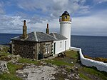 | ||
| Isle Of May North Horn | Isle of May | 56°11′27″N2°33′51″W / 56.190909°N 2.564224°W | Category C(S) | 2688 |  | ||
| Isle Of May Fluke Street Former Coal Store And Stable Block | Isle of May | 56°11′02″N2°33′16″W / 56.184025°N 2.554505°W | Category B | 2713 | |