| Name | Location | Date Listed | Grid Ref. [note 1] | Geo-coordinates | Notes | LB Number [note 2] | Image |
|---|
|
| Balloch Castle, Walled Garden | | | | 56°00′32″N4°34′57″W / 56.008914°N 4.582409°W / 56.008914; -4.582409 (Balloch Castle, Walled Garden) | Category B | 43222 |  |
| Jamestown Primary School With Boundary Wall And Railings | | | | 55°59′54″N4°34′14″W / 55.99845°N 4.570451°W / 55.99845; -4.570451 (Jamestown Primary School With Boundary Wall And Railings) | Category C(S) | 43226 | 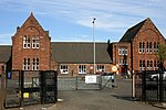 Upload another image
|
| Lower Stoneymullen Road, Drumkinnon Farm | | | | 55°59′59″N4°35′51″W / 55.99979°N 4.597422°W / 55.99979; -4.597422 (Lower Stoneymullen Road, Drumkinnon Farm) | Category B | 4903 | |
| Bonhill Parish Church With Boundary Wall And Graveyard | | | | 55°58′58″N4°34′27″W / 55.982677°N 4.574294°W / 55.982677; -4.574294 (Bonhill Parish Church With Boundary Wall And Graveyard) | Category B | 1095 | 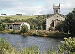 Upload another image
See more images |
| Westerton House With Gatepiers And Walled Garden | | | | 56°01′05″N4°32′52″W / 56.017939°N 4.547805°W / 56.017939; -4.547805 (Westerton House With Gatepiers And Walled Garden) | Category B | 1127 | |
| Jamestown Parish Church Of Scotland With Boundary Wall Railings And Gatepiers | | | | 55°59′53″N4°34′15″W / 55.998163°N 4.570833°W / 55.998163; -4.570833 (Jamestown Parish Church Of Scotland With Boundary Wall Railings And Gatepiers) | Category B | 1137 | 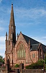 Upload another image
See more images |
| Balloch Castle | | | | 56°00′47″N4°35′01″W / 56.01303°N 4.583694°W / 56.01303; -4.583694 (Balloch Castle) | Category A | 123 | 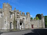 Upload another image
|
| Alexandria, North Main Street, Argyll Motor Works With Lodge, Gatepiers, Railings And Boundary Wall | | | | 55°59′31″N4°35′02″W / 55.991924°N 4.583825°W / 55.991924; -4.583825 (Alexandria, North Main Street, Argyll Motor Works With Lodge, Gatepiers, Railings And Boundary Wall) | Category A | 127 |  Upload another image
See more images |
| Alexandria, Bank Street, Vale Of Leven Constitutional Club | | | | 55°59′11″N4°34′40″W / 55.986487°N 4.57777°W / 55.986487; -4.57777 (Alexandria, Bank Street, Vale Of Leven Constitutional Club) | Category C(S) | 43194 |  Upload another image
See more images |
| Alexandria, 252 Main Street | | | | 55°59′07″N4°34′53″W / 55.985144°N 4.581368°W / 55.985144; -4.581368 (Alexandria, 252 Main Street) | Category C(S) | 43201 | |
| Alexandria, Queen's Drive, Saint Mungo's Episcopal Church With Hall, Boundary Wall And Gatepiers | | | | 55°58′54″N4°35′01″W / 55.981772°N 4.583596°W / 55.981772; -4.583596 (Alexandria, Queen's Drive, Saint Mungo's Episcopal Church With Hall, Boundary Wall And Gatepiers) | Category B | 43210 | |
| Balloch, Drymen Road, Tullichewan Hotel | | | | 56°00′10″N4°35′00″W / 56.002747°N 4.583313°W / 56.002747; -4.583313 (Balloch, Drymen Road, Tullichewan Hotel) | Category C(S) | 43217 | |
| Balloch, Lomond Road, Bridge | | | | 56°00′06″N4°34′52″W / 56.00159°N 4.581054°W / 56.00159; -4.581054 (Balloch, Lomond Road, Bridge) | Category B | 43218 | |
| Balloch, Lomond Road, Fisherwood | | | | 56°00′04″N4°34′55″W / 56.001043°N 4.581867°W / 56.001043; -4.581867 (Balloch, Lomond Road, Fisherwood) | Category B | 43219 |  Upload another image
|
| Alexandria, Christie Park, War Memorial | | | | 55°59′25″N4°35′06″W / 55.990266°N 4.584869°W / 55.990266; -4.584869 (Alexandria, Christie Park, War Memorial) | Category B | 43197 | 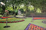 Upload another image
|
| Alexandria, Overton Road, Vale Of Leven Cemetery With Monuments, Bridge, Boundary Wall, Gates And Gatepiers | | | | 55°59′03″N4°35′29″W / 55.984042°N 4.591476°W / 55.984042; -4.591476 (Alexandria, Overton Road, Vale Of Leven Cemetery With Monuments, Bridge, Boundary Wall, Gates And Gatepiers) | Category B | 43206 | |
| Balloch, Balloch Road Bridge | | | | 56°00′12″N4°34′55″W / 56.003389°N 4.581848°W / 56.003389; -4.581848 (Balloch, Balloch Road Bridge) | Category B | 43215 | |
| Cameron House, Mid Lodge With Boundary Wall, Gatepiers, Gates And Railings | | | | 56°00′48″N4°36′40″W / 56.013467°N 4.611161°W / 56.013467; -4.611161 (Cameron House, Mid Lodge With Boundary Wall, Gatepiers, Gates And Railings) | Category B | 1122 | |
| Alexandria, Gilmour Street, Masonic Temple | | | | 55°59′13″N4°35′07″W / 55.987033°N 4.585166°W / 55.987033; -4.585166 (Alexandria, Gilmour Street, Masonic Temple) | Category A | 1135 |  Upload another image
|
| Alexandria, Main Street, Saint Andrew's Parish Church With Gatepiers, Railings, Graveyard And Smollett Mausoleum | | | | 55°59′08″N4°34′47″W / 55.98551°N 4.579757°W / 55.98551; -4.579757 (Alexandria, Main Street, Saint Andrew's Parish Church With Gatepiers, Railings, Graveyard And Smollett Mausoleum) | Category B | 1136 | |
| Alexandria, Glen Alwyn Lodge With Gatepiers And Wall | | | | 56°00′05″N4°35′31″W / 56.001265°N 4.591827°W / 56.001265; -4.591827 (Alexandria, Glen Alwyn Lodge With Gatepiers And Wall) | Category B | 91 | |
| Alexandria, Albert Street, Methodist Church With Gatepiers And Railings | | | | 55°59′01″N4°34′50″W / 55.983671°N 4.580485°W / 55.983671; -4.580485 (Alexandria, Albert Street, Methodist Church With Gatepiers And Railings) | Category C(S) | 43191 | |
| Alexandria, Bank Street, Post Office With Gatepiers And Boundary Wall | | | | 55°59′11″N4°34′39″W / 55.986438°N 4.577542°W / 55.986438; -4.577542 (Alexandria, Bank Street, Post Office With Gatepiers And Boundary Wall) | Category C(S) | 43192 | |
| Alexandria, 304 Main Street, Ardenlee With Boundary Wall And Gatepiers | | | | 55°59′02″N4°34′54″W / 55.983851°N 4.581747°W / 55.983851; -4.581747 (Alexandria, 304 Main Street, Ardenlee With Boundary Wall And Gatepiers) | Category C(S) | 43198 | |
| Alexandria, Overton Road, Kirkland With Boundary Wall And Gatepiers | | | | 55°59′08″N4°35′08″W / 55.985559°N 4.585597°W / 55.985559; -4.585597 (Alexandria, Overton Road, Kirkland With Boundary Wall And Gatepiers) | Category C(S) | 43205 | |
| Balloch Castle, North Lodge With Gatepiers And Boundary Wall | | | | 56°00′48″N4°34′31″W / 56.013412°N 4.57536°W / 56.013412; -4.57536 (Balloch Castle, North Lodge With Gatepiers And Boundary Wall) | Category C(S) | 43220 | |
| Alexandria, Gilmour Street, Ewing Gilmour Institute | | | | 55°59′14″N4°34′58″W / 55.987209°N 4.582789°W / 55.987209; -4.582789 (Alexandria, Gilmour Street, Ewing Gilmour Institute) | Category B | 1096 | 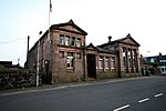 Upload another image
|
| Cameron House With Terrace Walls | | | | 56°00′48″N4°36′29″W / 56.013397°N 4.608124°W / 56.013397; -4.608124 (Cameron House With Terrace Walls) | Category B | 1121 | 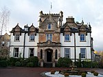 Upload another image
|
| Alexandria, Christie Park With Lodge, Gates, Gatepiers And Boundary Wall | | | | 55°59′23″N4°35′02″W / 55.989605°N 4.583799°W / 55.989605; -4.583799 (Alexandria, Christie Park With Lodge, Gates, Gatepiers And Boundary Wall) | Category B | 43196 | |
| Alexandria, 354 Main Street, With Boundary Wall | | | | 55°58′56″N4°34′59″W / 55.982233°N 4.583034°W / 55.982233; -4.583034 (Alexandria, 354 Main Street, With Boundary Wall) | Category C(S) | 43202 | |
| Alexandria, North Main Street, Bellville With Boundary Wall | | | | 55°59′25″N4°35′01″W / 55.990318°N 4.583654°W / 55.990318; -4.583654 (Alexandria, North Main Street, Bellville With Boundary Wall) | Category B | 43203 | |
| Alexandria, North Main Street, Lodge With Boundary Walls, Gates And Gatepiers | | | | 55°59′27″N4°35′04″W / 55.990831°N 4.584506°W / 55.990831; -4.584506 (Alexandria, North Main Street, Lodge With Boundary Walls, Gates And Gatepiers) | Category B | 43204 | |
| Alexandria, Middleton Street, Christie Park Primary School With Gatepiers And Boundary Wall And Railings | | | | 55°59′19″N4°35′08″W / 55.988651°N 4.585595°W / 55.988651; -4.585595 (Alexandria, Middleton Street, Christie Park Primary School With Gatepiers And Boundary Wall And Railings) | Category C(S) | 6610 | |
| Alexandria, Smollett Fountain With Lamp Standards | | | | 55°59′16″N4°34′56″W / 55.987798°N 4.582123°W / 55.987798; -4.582123 (Alexandria, Smollett Fountain With Lamp Standards) | Category B | 1134 |  Upload another image
|
| Loch Lomond, Drumkinnon Bay, Winch House Including Slipway | | | | 56°00′28″N4°35′27″W / 56.007782°N 4.590964°W / 56.007782; -4.590964 (Loch Lomond, Drumkinnon Bay, Winch House Including Slipway) | Category A | 46721 | 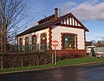 Upload another image
See more images |
| Bonhill, 120-122 (Even Nos), Main Street And Adjoining Workshop | | | | 55°59′08″N4°34′22″W / 55.985549°N 4.572769°W / 55.985549; -4.572769 (Bonhill, 120-122 (Even Nos), Main Street And Adjoining Workshop) | Category B | 43224 | |
| Lower Stoneymollen Road, Drumkinnon Farm, Mill, Granary And Saw Mill | | | | 55°59′58″N4°35′50″W / 55.999444°N 4.597207°W / 55.999444; -4.597207 (Lower Stoneymollen Road, Drumkinnon Farm, Mill, Granary And Saw Mill) | Category B | 43229 | |
| Westerton Lodge Gatepiers And Boundary Wall | | | | 56°00′52″N4°33′04″W / 56.014573°N 4.551049°W / 56.014573; -4.551049 (Westerton Lodge Gatepiers And Boundary Wall) | Category C(S) | 43232 | 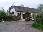 Upload another image
See more images |
| Alexandria, 320 Main Street, Niagra With Boundary Walls | | | | 55°59′00″N4°34′56″W / 55.983331°N 4.582097°W / 55.983331; -4.582097 (Alexandria, 320 Main Street, Niagra With Boundary Walls) | Category C(S) | 43199 | |
| Alexandria, Upper Smollett Road, Alexandria House With Boundary Walls And Gatepiers | | | | 55°59′05″N4°35′08″W / 55.984589°N 4.585532°W / 55.984589; -4.585532 (Alexandria, Upper Smollett Road, Alexandria House With Boundary Walls And Gatepiers) | Category C(S) | 43212 | |
| Balloch, Drymen Road, The Cottage With Gatepiers And Boundary Wall | | | | 56°00′21″N4°34′18″W / 56.005807°N 4.571534°W / 56.005807; -4.571534 (Balloch, Drymen Road, The Cottage With Gatepiers And Boundary Wall) | Category C(S) | 43216 | |
| Woodbank House With Garden Building | | | | 56°00′05″N4°35′47″W / 56.001384°N 4.596407°W / 56.001384; -4.596407 (Woodbank House With Garden Building) | Category A | 1125 |  Upload another image
See more images |
| Balloch Castle, South Lodge With Boundary Walls And Gatepiers | | | | 56°00′17″N4°34′36″W / 56.004618°N 4.576796°W / 56.004618; -4.576796 (Balloch Castle, South Lodge With Boundary Walls And Gatepiers) | Category B | 43221 | |
| Bonhill, Jamestown Road, Dalmonach Print And Dye Works, Lodge | | | | 55°59′21″N4°34′21″W / 55.989255°N 4.572615°W / 55.989255; -4.572615 (Bonhill, Jamestown Road, Dalmonach Print And Dye Works, Lodge) | Category C(S) | 43223 | |
| Tullichewan Estate, Stables Cottage | | | | 55°59′43″N4°35′46″W / 55.995155°N 4.596005°W / 55.995155; -4.596005 (Tullichewan Estate, Stables Cottage) | Category B | 43230 | |
| Cameron House, South Lodge With Gatepiers And Boundary Wall | | | | 56°00′16″N4°35′55″W / 56.004332°N 4.598577°W / 56.004332; -4.598577 (Cameron House, South Lodge With Gatepiers And Boundary Wall) | Category B | 4904 | |
| Alexandria, Bank Street, Vale Of Leven Bingo Club With Boundary Wall, Railings And Portals | | | | 55°59′06″N4°34′29″W / 55.98502°N 4.574835°W / 55.98502; -4.574835 (Alexandria, Bank Street, Vale Of Leven Bingo Club With Boundary Wall, Railings And Portals) | Category B | 43193 | |
| Alexandria, 127-133, Main Street, Bank Of Scotland | | | | 55°59′13″N4°34′53″W / 55.987059°N 4.581336°W / 55.987059; -4.581336 (Alexandria, 127-133, Main Street, Bank Of Scotland) | Category C(S) | 43200 | |
| Drumkinnon Cottage With Wall And Railings | | | | 56°00′16″N4°35′51″W / 56.004327°N 4.597502°W / 56.004327; -4.597502 (Drumkinnon Cottage With Wall And Railings) | Category C(S) | 1124 | |


