Name Location Date Listed Grid Ref. [note 1] Geo-coordinates Notes LB Number [note 2] Image Arncroach Village Main Road. Lundie Cottage, Garden Wall And Gates 56°14′10″N 2°47′09″W / 56.23605°N 2.785852°W / 56.23605; -2.785852 (Arncroach Village Main Road. Lundie Cottage, Garden Wall And Gates ) Category B 2502 Balcormo Farm Gatepiers 56°13′46″N 2°47′04″W / 56.229392°N 2.78457°W / 56.229392; -2.78457 (Balcormo Farm Gatepiers ) Category C(S) 2510 Balcormo House Gatepiers 56°13′47″N 2°46′54″W / 56.22985°N 2.781757°W / 56.22985; -2.781757 (Balcormo House Gatepiers ) Category B 2511 Carnbee Village Carnbee Parish Church, Cemetery, Walls & Gatepiers 56°14′56″N 2°45′27″W / 56.249021°N 2.757521°W / 56.249021; -2.757521 (Carnbee Village Carnbee Parish Church, Cemetery, Walls & Gatepiers ) Category B 2512 Upload another image See more images
Dreel House (Former Free Kirk Manse) And Former Stable Block 56°14′21″N 2°47′38″W / 56.239134°N 2.79395°W / 56.239134; -2.79395 (Dreel House (Former Free Kirk Manse) And Former Stable Block ) Category C(S) 2515 Comielaw Farmhouse And Steading 56°13′52″N 2°46′28″W / 56.231199°N 2.774381°W / 56.231199; -2.774381 (Comielaw Farmhouse And Steading ) Category B 4308 South Cassingray Farmhouse 56°15′26″N 2°50′00″W / 56.257115°N 2.833239°W / 56.257115; -2.833239 (South Cassingray Farmhouse ) Category C(S) 2540 Balcaskie House 56°13′21″N 2°46′05″W / 56.222388°N 2.768091°W / 56.222388; -2.768091 (Balcaskie House ) Category A 2503 Balcaskie House, Terraced Garden 56°13′18″N 2°46′03″W / 56.221753°N 2.76761°W / 56.221753; -2.76761 (Balcaskie House, Terraced Garden ) Category A 2504 Upload another image
Kellie Castle , Stable Courtyard and Walled Garden 56°14′15″N 2°46′32″W / 56.237589°N 2.775429°W / 56.237589; -2.775429 (Kellie Castle, Stable Courtyard and Walled Garden ) Category A 2519 Upload another image See more images
Arncroach Village Main Road W. Stewart 56°14′10″N 2°47′12″W / 56.23618°N 2.786581°W / 56.23618; -2.786581 (Arncroach Village Main Road W. Stewart ) Category C(S) 2528 Balcaskie House: Bridge On West Drive 56°13′22″N 2°46′25″W / 56.222695°N 2.773693°W / 56.222695; -2.773693 (Balcaskie House: Bridge On West Drive ) Category B 2508 Upload another image
Gibliston House Former Stable Block 56°14′09″N 2°48′43″W / 56.235721°N 2.811834°W / 56.235721; -2.811834 (Gibliston House Former Stable Block ) Category C(S) 2517 Gillingshill House 56°14′48″N 2°47′22″W / 56.246727°N 2.789556°W / 56.246727; -2.789556 (Gillingshill House ) Category B 2518 Kellie Castle, Kellie Mausoleum 56°14′06″N 2°46′41″W / 56.235103°N 2.777992°W / 56.235103; -2.777992 (Kellie Castle, Kellie Mausoleum ) Category C(S) 4309 Balcaskie House East Gatepiers And Twin Dovecots 56°13′31″N 2°45′33″W / 56.225211°N 2.759083°W / 56.225211; -2.759083 (Balcaskie House East Gatepiers And Twin Dovecots ) Category A 2506 Upload another image
Carnbee Village War Memorial 56°14′57″N 2°45′30″W / 56.249061°N 2.758297°W / 56.249061; -2.758297 (Carnbee Village War Memorial ) Category B 2514 Upload another image
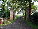
Balcaskie House: North Drive Gatepiers 56°13′32″N 2°46′15″W / 56.225606°N 2.77072°W / 56.225606; -2.77072 (Balcaskie House: North Drive Gatepiers ) Category B 2507 Upload another image
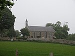
Arncroach Village Main Road Old Free Church 56°14′08″N 2°47′09″W / 56.235664°N 2.785892°W / 56.235664; -2.785892 (Arncroach Village Main Road Old Free Church ) Category B 2501 Balcaskie House: Home Farm 56°13′24″N 2°45′54″W / 56.223253°N 2.764915°W / 56.223253; -2.764915 (Balcaskie House: Home Farm ) Category C(S) 2509 Balcaskie House, East Lodge 56°13′30″N 2°45′33″W / 56.224968°N 2.759208°W / 56.224968; -2.759208 (Balcaskie House, East Lodge ) Category B 2505 Kellie Castle Gatepiers 56°14′08″N 2°46′37″W / 56.235631°N 2.776906°W / 56.235631; -2.776906 (Kellie Castle Gatepiers ) Category C(S) 2520 Upload another image
Newton Of Balcormo Hutcheson And J Blyde 56°13′57″N 2°46′41″W / 56.232372°N 2.777921°W / 56.232372; -2.777921 (Newton Of Balcormo Hutcheson And J Blyde ) Category B 2521 Gibliston House 56°14′05″N 2°48′41″W / 56.234691°N 2.811296°W / 56.234691; -2.811296 (Gibliston House ) Category A 155 Carnbee Village Carnbee House (Formerly Carnbee Manse) 56°14′49″N 2°45′24″W / 56.246969°N 2.756577°W / 56.246969; -2.756577 (Carnbee Village Carnbee House (Formerly Carnbee Manse) ) Category B 2513 Gibliston Farmhouse And Steading 56°14′22″N 2°49′04″W / 56.239383°N 2.817849°W / 56.239383; -2.817849 (Gibliston Farmhouse And Steading ) Category B 2516 Arncroach Village Blinkbonny Road/Main Road Corner House 56°14′10″N 2°47′12″W / 56.236118°N 2.786547°W / 56.236118; -2.786547 (Arncroach Village Blinkbonny Road/Main Road Corner House ) Category B 2527