Name Location Date Listed Grid Ref. [note 1] Geo-coordinates Notes LB Number [note 2] Image Crichton Castle, Stables 55°50′20″N 2°59′29″W / 55.839012°N 2.991424°W / 55.839012; -2.991424 (Crichton Castle, Stables ) Category A 755 Upload another image See more images
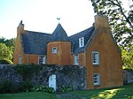
Ford, Ford House And Walled Garden 55°52′07″N 2°58′39″W / 55.868516°N 2.977362°W / 55.868516; -2.977362 (Ford, Ford House And Walled Garden ) Category A 756 Upload another image See more images
Crichton House, East And West Wings 55°51′06″N 2°57′34″W / 55.851738°N 2.95937°W / 55.851738; -2.95937 (Crichton House, East And West Wings ) Category A 757 Upload another image
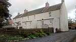
Crichton, Crichton Mains 55°50′50″N 2°58′46″W / 55.847095°N 2.979571°W / 55.847095; -2.979571 (Crichton, Crichton Mains ) Category B 47759 Upload another image
Pathhead, 7 Main Street 55°52′08″N 2°58′17″W / 55.868842°N 2.971377°W / 55.868842; -2.971377 (Pathhead, 7 Main Street ) Category C(S) 47763 Pathhead, 23 Main Street, Boundary Wall And Wrought-Iron Railings 55°52′07″N 2°58′13″W / 55.868724°N 2.970416°W / 55.868724; -2.970416 (Pathhead, 23 Main Street, Boundary Wall And Wrought-Iron Railings ) Category C(S) 47764 Saughland Farm Cottages And Boundary Walls 55°50′23″N 2°56′00″W / 55.839727°N 2.933397°W / 55.839727; -2.933397 (Saughland Farm Cottages And Boundary Walls ) Category C(S) 47771 Tynebank And Cottages 55°51′18″N 2°58′54″W / 55.855058°N 2.981577°W / 55.855058; -2.981577 (Tynebank And Cottages ) Category B 47772 Crichton Castle 55°50′22″N 2°59′30″W / 55.839478°N 2.991563°W / 55.839478; -2.991563 (Crichton Castle ) Category A 754 Upload another image
Costerton, Former Costerton House, Doocot 55°51′35″N 2°54′04″W / 55.859708°N 2.901077°W / 55.859708; -2.901077 (Costerton, Former Costerton House, Doocot ) Category C(S) 758 Crichton Village, Cottages 10-14 (Inclusive Numbers) 55°50′49″N 2°58′59″W / 55.846978°N 2.982986°W / 55.846978; -2.982986 (Crichton Village, Cottages 10-14 (Inclusive Numbers) ) Category B 765 Pathhead, 75-77 (Odd Numbers) Main Street 55°52′03″N 2°58′02″W / 55.867571°N 2.967351°W / 55.867571; -2.967351 (Pathhead, 75-77 (Odd Numbers) Main Street ) Category C(S) 47767 Cakemuir Castle, Including Walled Garden, Stable Range And Cottage 55°49′17″N 2°56′20″W / 55.821471°N 2.938993°W / 55.821471; -2.938993 (Cakemuir Castle, Including Walled Garden, Stable Range And Cottage ) Category B 764 Tynehead, Station Cottage 55°49′19″N 2°58′09″W / 55.822055°N 2.96903°W / 55.822055; -2.96903 (Tynehead, Station Cottage ) Category C(S) 47773 12 Fala Dam, White House 55°50′38″N 2°54′49″W / 55.84391°N 2.913567°W / 55.84391; -2.913567 (12 Fala Dam, White House ) Category C(S) 760 8 Fala Dam, The Dam House 55°50′38″N 2°54′50″W / 55.843889°N 2.913982°W / 55.843889; -2.913982 (8 Fala Dam, The Dam House ) Category C(S) 112 Crichton Manse Including Garden Buildings, Railings And Garden Walls 55°50′39″N 2°59′28″W / 55.844136°N 2.991155°W / 55.844136; -2.991155 (Crichton Manse Including Garden Buildings, Railings And Garden Walls ) Category B 6681 Pathhead, 71-73 (Odd Numbers) Main Street 55°52′03″N 2°58′02″W / 55.867571°N 2.967351°W / 55.867571; -2.967351 (Pathhead, 71-73 (Odd Numbers) Main Street ) Category C(S) 5092 10 Fala Dam, Laggan Cottage 55°50′38″N 2°54′50″W / 55.843918°N 2.913775°W / 55.843918; -2.913775 (10 Fala Dam, Laggan Cottage ) Category C(S) 759 Longfaugh Farm House 55°50′47″N 2°56′47″W / 55.846394°N 2.946286°W / 55.846394; -2.946286 (Longfaugh Farm House ) Category C(S) 763 Costerton, Former Costerton House Icehouse 55°51′35″N 2°54′09″W / 55.859859°N 2.902566°W / 55.859859; -2.902566 (Costerton, Former Costerton House Icehouse ) Category B 47757 Pathhead, 39 Main Street 55°52′06″N 2°58′08″W / 55.868349°N 2.968872°W / 55.868349; -2.968872 (Pathhead, 39 Main Street ) Category C(S) 47765 Pathhead, 57 Main Street, Grey's House 55°52′05″N 2°58′05″W / 55.868022°N 2.968177°W / 55.868022; -2.968177 (Pathhead, 57 Main Street, Grey's House ) Category C(S) 47766 Pathhead, 119 Main Street 55°51′58″N 2°57′56″W / 55.866245°N 2.965656°W / 55.866245; -2.965656 (Pathhead, 119 Main Street ) Category C(S) 47768 Pathhead, 172 Main Street 55°51′53″N 2°57′52″W / 55.8647°N 2.964419°W / 55.8647; -2.964419 (Pathhead, 172 Main Street ) Category C(S) 47770 Costerton, Costerton House (Former Gardener's Cottage) And Walled Garden 55°51′31″N 2°54′15″W / 55.858491°N 2.90418°W / 55.858491; -2.90418 (Costerton, Costerton House (Former Gardener's Cottage) And Walled Garden ) Category C(S) 47756 Pathhead, 159 Main Street 55°51′55″N 2°57′51″W / 55.865196°N 2.964288°W / 55.865196; -2.964288 (Pathhead, 159 Main Street ) Category C(S) 47769 Lothian Bridge, Tyne Valley 55°52′12″N 2°58′29″W / 55.870046°N 2.974763°W / 55.870046; -2.974763 (Lothian Bridge, Tyne Valley ) Category A 5090 Upload another image See more images
Crichton Kirk (Formerly Collegiate Church Of S.S. Mary And Kentigern) Including Graveyard 55°50′37″N 2°59′25″W / 55.843747°N 2.990362°W / 55.843747; -2.990362 (Crichton Kirk (Formerly Collegiate Church Of S.S. Mary And Kentigern) Including Graveyard ) Category A 753 Upload another image
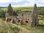
14 Fala Dam, Falaburn House 55°50′38″N 2°54′47″W / 55.843968°N 2.913041°W / 55.843968; -2.913041 (14 Fala Dam, Falaburn House ) Category C(S) 761 Pathhead, 47 Main Street 55°52′05″N 2°58′07″W / 55.868191°N 2.968501°W / 55.868191; -2.968501 (Pathhead, 47 Main Street ) Category C(S) 5091 Bridge, Fala Dam Burn 55°50′39″N 2°54′46″W / 55.84415°N 2.912662°W / 55.84415; -2.912662 (Bridge, Fala Dam Burn ) Category C(S) 762 Crichton Limekilns, Pathhead 55°50′37″N 2°58′15″W / 55.843687°N 2.970846°W / 55.843687; -2.970846 (Crichton Limekilns, Pathhead ) Category C(S) 47758