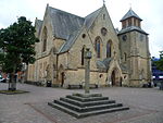
Name Location Date Listed Grid Ref. [note 1] Geo-coordinates Notes LB Number [note 2] Image Old Cumnock Old Church 55°27′15″N 4°15′58″W / 55.454244°N 4.266028°W / 55.454244; -4.266028 (Old Cumnock Old Church ) Category B 24092 Upload another image
The Snug Bar The Square 55°27′16″N 4°15′59″W / 55.454318°N 4.266428°W / 55.454318; -4.266428 (The Snug Bar The Square ) Category C(S) 24103 The Royal Hotel 44, 45, 46 The Square 55°27′16″N 4°15′56″W / 55.454363°N 4.26545°W / 55.454363; -4.26545 (The Royal Hotel 44, 45, 46 The Square ) Category C(S) 24107 The Craighead Inn 55°27′15″N 4°15′54″W / 55.454163°N 4.265075°W / 55.454163; -4.265075 (The Craighead Inn ) Category C(S) 24108 No 15 Glaisnock Street 55°27′16″N 4°15′53″W / 55.454306°N 4.264672°W / 55.454306; -4.264672 (No 15 Glaisnock Street ) Category C(S) 24113 No 18 Glaisnock Street 55°27′13″N 4°15′54″W / 55.453679°N 4.265031°W / 55.453679; -4.265031 (No 18 Glaisnock Street ) Category C(S) 24116 Congregational Church And Manse Auchinleck Road 55°27′20″N 4°16′07″W / 55.455598°N 4.268668°W / 55.455598; -4.268668 (Congregational Church And Manse Auchinleck Road ) Category C(S) 24130 Bank (Or Templand) Railway Viaduct Over Lugar Water In Woodroad Park 55°27′31″N 4°15′24″W / 55.458622°N 4.256789°W / 55.458622; -4.256789 (Bank (Or Templand) Railway Viaduct Over Lugar Water In Woodroad Park ) Category A 24133 Upload another image See more images
No 22 The Square 55°27′15″N 4°15′59″W / 55.454111°N 4.266464°W / 55.454111; -4.266464 (No 22 The Square ) Category B 24101 Cumnock, 65 And 67 Glaisnock Street, Royal Bank Of Scotland 55°27′12″N 4°15′51″W / 55.453328°N 4.264046°W / 55.453328; -4.264046 (Cumnock, 65 And 67 Glaisnock Street, Royal Bank Of Scotland ) Category B 24111 Crichton Church Of Scotland Ayr Road 55°27′11″N 4°15′57″W / 55.453017°N 4.265816°W / 55.453017; -4.265816 (Crichton Church Of Scotland Ayr Road ) Category B 24123 Nos 1, 2 The Square 55°27′14″N 4°15′56″W / 55.45401°N 4.265572°W / 55.45401; -4.265572 (Nos 1, 2 The Square ) Category C(S) 24094 The Mercat Hotel, Formerly The Black Bull Hotel, The Square 55°27′16″N 4°15′56″W / 55.454567°N 4.265604°W / 55.454567; -4.265604 (The Mercat Hotel, Formerly The Black Bull Hotel, The Square ) Category B 24106 Cumnock, Glaisnock Street, Dumfries Arms Hotel 55°27′10″N 4°15′50″W / 55.452686°N 4.263804°W / 55.452686; -4.263804 (Cumnock, Glaisnock Street, Dumfries Arms Hotel ) Category B 24112 No 17 Glaisnock Street 55°27′15″N 4°15′54″W / 55.454121°N 4.264914°W / 55.454121; -4.264914 (No 17 Glaisnock Street ) Category C(S) 24114 Nos 12-16 Glaisnock Street 55°27′14″N 4°15′54″W / 55.453785°N 4.265116°W / 55.453785; -4.265116 (Nos 12-16 Glaisnock Street ) Category C(S) 24115 Cumnock, 21 Ayr Road, Including Gatepiers And Boundary Wall 55°27′08″N 4°15′57″W / 55.452119°N 4.26578°W / 55.452119; -4.26578 (Cumnock, 21 Ayr Road, Including Gatepiers And Boundary Wall ) Category B 24121 Strathcylde Regional Supplies Department (Former United Session Church), Tanyard 55°27′10″N 4°16′02″W / 55.452872°N 4.267357°W / 55.452872; -4.267357 (Strathcylde Regional Supplies Department (Former United Session Church), Tanyard ) Category C(S) 24125 Former Railway Viaduct Now Footbridge, Murray Park 55°26′55″N 4°15′24″W / 55.448703°N 4.256586°W / 55.448703; -4.256586 (Former Railway Viaduct Now Footbridge, Murray Park ) Category B 24134 Nos 18, 19, 20 The Square 55°27′14″N 4°15′59″W / 55.453957°N 4.266486°W / 55.453957; -4.266486 (Nos 18, 19, 20 The Square ) Category C(S) 24099 No 38 The Square 55°27′17″N 4°15′57″W / 55.454606°N 4.265923°W / 55.454606; -4.265923 (No 38 The Square ) Category C(S) 24105 Town Hall, Glaisnock Street 55°27′08″N 4°15′50″W / 55.452227°N 4.263841°W / 55.452227; -4.263841 (Town Hall, Glaisnock Street ) Category C(S) 24119 Upload another image
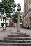
Nos 38-42 Ayr Road 55°27′11″N 4°15′55″W / 55.452971°N 4.265386°W / 55.452971; -4.265386 (Nos 38-42 Ayr Road ) Category B 24122 Lugar (Or Stepends) Bridge Over Lugar Water 55°27′18″N 4°16′04″W / 55.455019°N 4.267892°W / 55.455019; -4.267892 (Lugar (Or Stepends) Bridge Over Lugar Water ) Category B 24129 Mercat Cross, The Square 55°27′14″N 4°15′58″W / 55.454025°N 4.266206°W / 55.454025; -4.266206 (Mercat Cross, The Square ) Category A 24093 Upload another image See more images
The Sun Inn, The Square 55°27′15″N 4°15′59″W / 55.454201°N 4.266437°W / 55.454201; -4.266437 (The Sun Inn, The Square ) Category B 24102 Cumnock, 61 And 63 Glaisnock Street 55°27′12″N 4°15′50″W / 55.45343°N 4.26391°W / 55.45343; -4.26391 (Cumnock, 61 And 63 Glaisnock Street ) Category B 24110 No 20 24 Glaisnock Street 55°27′13″N 4°15′54″W / 55.45359°N 4.264947°W / 55.45359; -4.264947 (No 20 24 Glaisnock Street ) Category C(S) 24117 Nos 1-3 Ayr Road 55°27′12″N 4°15′52″W / 55.453223°N 4.264404°W / 55.453223; -4.264404 (Nos 1-3 Ayr Road ) Category C(S) 24118 Broomfield, Auchinleck Road 55°27′17″N 4°16′25″W / 55.454851°N 4.27356°W / 55.454851; -4.27356 (Broomfield, Auchinleck Road ) Category B 24131 Nos 9, 10, 11 The Square 55°27′14″N 4°15′58″W / 55.45383°N 4.2661°W / 55.45383; -4.2661 (Nos 9, 10, 11 The Square ) Category C(S) 24098 No 21 The Square 55°27′15″N 4°15′59″W / 55.454047°N 4.266492°W / 55.454047; -4.266492 (No 21 The Square ) Category C(S) 24100 The Clydesdale Bank The Square 55°27′16″N 4°15′58″W / 55.454556°N 4.26622°W / 55.454556; -4.26622 (The Clydesdale Bank The Square ) Category B 24104 Strathclyde Regional Council Area Office, Off Lugar Street 55°27′20″N 4°15′58″W / 55.455638°N 4.266013°W / 55.455638; -4.266013 (Strathclyde Regional Council Area Office, Off Lugar Street ) Category C(S) 24126 Nos 3, 4 5 The Square Gospel Hall 55°27′14″N 4°15′57″W / 55.453953°N 4.265759°W / 55.453953; -4.265759 (Nos 3, 4 5 The Square Gospel Hall ) Category B 24095 No 6 The Square 55°27′14″N 4°15′57″W / 55.453942°N 4.265869°W / 55.453942; -4.265869 (No 6 The Square ) Category B 24096 St John's R.C. Church Glaisnock Street 55°26′58″N 4°15′41″W / 55.449414°N 4.261387°W / 55.449414; -4.261387 (St John's R.C. Church Glaisnock Street ) Category B 24120 Graveyard Barrhill Road 55°27′20″N 4°15′45″W / 55.455615°N 4.262374°W / 55.455615; -4.262374 (Graveyard Barrhill Road ) Category C(S) 24132 3 Lugar Street, The Baird Institute 55°27′16″N 4°16′01″W / 55.45432°N 4.266824°W / 55.45432; -4.266824 (3 Lugar Street, The Baird Institute ) Category C(S) 50889 No 7, 8 The Square 55°27′14″N 4°15′58″W / 55.453921°N 4.26601°W / 55.453921; -4.26601 (No 7, 8 The Square ) Category B 24097 Cumnock, 55 And 57 Glaisnock Street 55°27′13″N 4°15′51″W / 55.453516°N 4.26412°W / 55.453516; -4.26412 (Cumnock, 55 And 57 Glaisnock Street ) Category C(S) 24109 Riverside, Lugar Street 55°27′18″N 4°16′02″W / 55.455065°N 4.267325°W / 55.455065; -4.267325 (Riverside, Lugar Street ) Category C(S) 24128 Auchinleck Road Lochnorris 55°27′18″N 4°16′21″W / 55.454986°N 4.272587°W / 55.454986; -4.272587 (Auchinleck Road Lochnorris ) Category B 24135