Name Location Date Listed Grid Ref. [note 1] Geo-coordinates Notes LB Number [note 2] Image Brodie Castle, Station Lodge And Gatepiers 57°35′38″N 3°42′39″W / 57.59378°N 3.710698°W / 57.59378; -3.710698 (Brodie Castle, Station Lodge And Gatepiers ) Category C(S) 2262 Brodie Castle, West Lodge 57°35′48″N 3°42′59″W / 57.59657°N 3.716318°W / 57.59657; -3.716318 (Brodie Castle, West Lodge ) Category C(S) 2263 Darnaway, Whitemire Village, No 63 (Pinewood) No 64 57°33′57″N 3°42′36″W / 57.565849°N 3.709973°W / 57.565849; -3.709973 (Darnaway, Whitemire Village, No 63 (Pinewood) No 64 ) Category B 2267 Earlsmill Bridge Over Muckle Burn 57°34′59″N 3°43′31″W / 57.582917°N 3.725343°W / 57.582917; -3.725343 (Earlsmill Bridge Over Muckle Burn ) Category C(S) 2270 Findhorn Bridge Over River Findhorn 57°36′08″N 3°39′19″W / 57.60212°N 3.655178°W / 57.60212; -3.655178 (Findhorn Bridge Over River Findhorn ) Category B 2273 Darnaway Castle, Stables And Carriage-House 57°34′25″N 3°40′57″W / 57.573505°N 3.682456°W / 57.573505; -3.682456 (Darnaway Castle, Stables And Carriage-House ) Category B 2284 Darnaway, West Lodge, Gatepiers And Gates 57°34′46″N 3°42′54″W / 57.579473°N 3.715027°W / 57.579473; -3.715027 (Darnaway, West Lodge, Gatepiers And Gates ) Category A 2288 Barleymill Bridge Over Muckle Burn 57°35′46″N 3°41′47″W / 57.596247°N 3.696307°W / 57.596247; -3.696307 (Barleymill Bridge Over Muckle Burn ) Category B 2258 Earlsmill House And Gatepiers 57°34′51″N 3°43′16″W / 57.580955°N 3.720985°W / 57.580955; -3.720985 (Earlsmill House And Gatepiers ) Category B 2271 Moy Mains, Former Stables And Carriage-Houses 57°37′15″N 3°38′53″W / 57.620712°N 3.647986°W / 57.620712; -3.647986 (Moy Mains, Former Stables And Carriage-Houses ) Category A 2276 Dalvey House, East Lodge And Gatepiers 57°36′21″N 3°39′54″W / 57.605764°N 3.665051°W / 57.605764; -3.665051 (Dalvey House, East Lodge And Gatepiers ) Category C(S) 2281 Dalvey Cottage 57°36′03″N 3°40′07″W / 57.600793°N 3.668672°W / 57.600793; -3.668672 (Dalvey Cottage ) Category B 2282 Moy Bridge Over Muckle Burn 57°37′22″N 3°39′04″W / 57.62264°N 3.651004°W / 57.62264; -3.651004 (Moy Bridge Over Muckle Burn ) Category B 2292 Bernera Cottage 57°36′38″N 3°40′59″W / 57.610573°N 3.683115°W / 57.610573; -3.683115 (Bernera Cottage ) Category B 2259 Darnaway, Whitemire Village, No 65 (The Neuk) 57°33′57″N 3°42′37″W / 57.565745°N 3.710353°W / 57.565745; -3.710353 (Darnaway, Whitemire Village, No 65 (The Neuk) ) Category B 2268 Dyke Parish Church (Church Of Scotland), Church Hall, (Former Mausoleum), Burial Ground And War Memorial Gate Arch 57°36′16″N 3°41′29″W / 57.604336°N 3.691378°W / 57.604336; -3.691378 (Dyke Parish Church (Church Of Scotland), Church Hall, (Former Mausoleum), Burial Ground And War Memorial Gate Arch ) Category A 2269 Upload another image
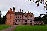
Kincorth House And Garden Walls 57°38′00″N 3°39′21″W / 57.633365°N 3.65593°W / 57.633365; -3.65593 (Kincorth House And Garden Walls ) Category B 2274 Moy House And Gatepiers 57°37′08″N 3°39′01″W / 57.618983°N 3.650353°W / 57.618983; -3.650353 (Moy House And Gatepiers ) Category A 2275 Dalvey House, Gardener's Cottage 57°36′23″N 3°39′59″W / 57.606384°N 3.666351°W / 57.606384; -3.666351 (Dalvey House, Gardener's Cottage ) Category C(S) 2280 Darnaway, Keeper's House And Kennels 57°34′58″N 3°40′48″W / 57.582783°N 3.679941°W / 57.582783; -3.679941 (Darnaway, Keeper's House And Kennels ) Category B 2286 Darnaway, East Lodge, Gatepiers And Gates 57°35′28″N 3°41′03″W / 57.591161°N 3.684292°W / 57.591161; -3.684292 (Darnaway, East Lodge, Gatepiers And Gates ) Category A 2287 Abbotshill Bridge Over Muckle Burn 57°36′16″N 3°40′43″W / 57.604569°N 3.678619°W / 57.604569; -3.678619 (Abbotshill Bridge Over Muckle Burn ) Category B 2257 Brodie Castle, Burial Ground 57°35′42″N 3°43′09″W / 57.595029°N 3.719257°W / 57.595029; -3.719257 (Brodie Castle, Burial Ground ) Category B 2264 Darnaway, Whitemire Village, No 59 (Kistie) No 60 (Randolph) 57°33′58″N 3°42′34″W / 57.566038°N 3.709313°W / 57.566038; -3.709313 (Darnaway, Whitemire Village, No 59 (Kistie) No 60 (Randolph) ) Category B 2265 Darnaway, Whitemire Village, No 61 (Stephen) No 62 57°33′57″N 3°42′35″W / 57.565897°N 3.709791°W / 57.565897; -3.709791 (Darnaway, Whitemire Village, No 61 (Stephen) No 62 ) Category C(S) 2266 Dalvey House 57°36′25″N 3°40′07″W / 57.606911°N 3.668635°W / 57.606911; -3.668635 (Dalvey House ) Category B 2277 Dalvey House, Dovecot 57°36′27″N 3°40′10″W / 57.60754°N 3.66935°W / 57.60754; -3.66935 (Dalvey House, Dovecot ) Category B 2278 Darnaway Castle And Terraces 57°34′28″N 3°41′02″W / 57.574519°N 3.683891°W / 57.574519; -3.683891 (Darnaway Castle And Terraces ) Category A 2283 Tearie Farmhouse 57°35′27″N 3°41′40″W / 57.590971°N 3.694455°W / 57.590971; -3.694455 (Tearie Farmhouse ) Category C(S) 2293 Darnaway, Walled Garden, East. Gatepiers And Gates (Redstone Nursery Gardens) 57°34′12″N 3°40′44″W / 57.570067°N 3.678853°W / 57.570067; -3.678853 (Darnaway, Walled Garden, East. Gatepiers And Gates (Redstone Nursery Gardens) ) Category B 2285 Dalvey House, Bridge Over The Muckle Burn 57°36′22″N 3°40′01″W / 57.60601°N 3.666819°W / 57.60601; -3.666819 (Dalvey House, Bridge Over The Muckle Burn ) Category B 2279 Brodie Castle 57°35′54″N 3°42′32″W / 57.598412°N 3.708958°W / 57.598412; -3.708958 (Brodie Castle ) Category A 2260 Upload another image
Brodie Castle, Stables 57°35′29″N 3°42′41″W / 57.591497°N 3.711478°W / 57.591497; -3.711478 (Brodie Castle, Stables ) Category B 2261 Feddan Farmhouse 57°35′12″N 3°43′38″W / 57.586656°N 3.727209°W / 57.586656; -3.727209 (Feddan Farmhouse ) Category B 2272