Name Location Date Listed Grid Ref. [note 1] Geo-coordinates Notes LB Number [note 2] Image Midtown, Inverasdale ,School,Former Free Church 57°48′04″N 5°40′06″W / 57.801054°N 5.668208°W / 57.801054; -5.668208 (Midtown, Inverasdale,School,Former Free Church ) Category B 12919 Badachro,Aird House 57°42′08″N 5°43′32″W / 57.702275°N 5.725578°W / 57.702275; -5.725578 (Badachro,Aird House ) Category C(S) 12920 Badachro Inn,Badachro,With Boathouse And Jetties 57°41′55″N 5°43′23″W / 57.698592°N 5.723033°W / 57.698592; -5.723033 (Badachro Inn,Badachro,With Boathouse And Jetties ) Category B 12921 South Erradale Causeway Over River Erradale (On B8056 Road) 57°40′29″N 5°47′07″W / 57.674735°N 5.785241°W / 57.674735; -5.785241 (South Erradale Causeway Over River Erradale (On B8056 Road) ) Category B 7901 Flowerdale House (Including Westerdale) And Walled Garden 57°42′53″N 5°40′17″W / 57.714717°N 5.671488°W / 57.714717; -5.671488 (Flowerdale House (Including Westerdale) And Walled Garden ) Category A 7910 Upload another image See more images
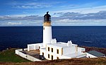
Gairloch, Strath, Strathgair House Steading And Walled Garden 57°43′56″N 5°41′55″W / 57.732144°N 5.6985°W / 57.732144; -5.6985 (Gairloch, Strath, Strathgair House Steading And Walled Garden ) Category C(S) 7887 Letterewe Furnace Cottage 57°40′38″N 5°25′24″W / 57.677091°N 5.423355°W / 57.677091; -5.423355 (Letterewe Furnace Cottage ) Category C(S) 7893 3 Mellon Udrigle 57°54′14″N 5°33′39″W / 57.903902°N 5.56086°W / 57.903902; -5.56086 (3 Mellon Udrigle ) Category B 7894 Poolewe The Old Manse 57°45′36″N 5°35′52″W / 57.759995°N 5.597789°W / 57.759995; -5.597789 (Poolewe The Old Manse ) Category C(S) 7897 Rubha Reidh Lighthouse 57°51′38″N 5°48′27″W / 57.860542°N 5.807502°W / 57.860542; -5.807502 (Rubha Reidh Lighthouse ) Category B 49894 Upload another image See more images
Charleston House 57°42′37″N 5°40′42″W / 57.710192°N 5.678403°W / 57.710192; -5.678403 (Charleston House ) Category B 12917 Poolewe Cliff House 57°46′02″N 5°36′32″W / 57.767239°N 5.608923°W / 57.767239; -5.608923 (Poolewe Cliff House ) Category B 7898 Kerrysdale House 57°41′51″N 5°39′25″W / 57.697455°N 5.656944°W / 57.697455; -5.656944 (Kerrysdale House ) Category C(S) 7889 Gairloch Old Kirkyard 57°43′13″N 5°41′12″W / 57.720372°N 5.686645°W / 57.720372; -5.686645 (Gairloch Old Kirkyard ) Category B 12918 Poolewe Srondubh House And Former Steading 57°46′14″N 5°35′47″W / 57.770434°N 5.596456°W / 57.770434; -5.596456 (Poolewe Srondubh House And Former Steading ) Category B 7900 27 Big Sand, House And Outbuilding 57°44′43″N 5°46′47″W / 57.74517°N 5.779746°W / 57.74517; -5.779746 (27 Big Sand, House And Outbuilding ) Category B 7908 Gairloch Parish Church, Church Of Scotland 57°42′59″N 5°40′58″W / 57.71648°N 5.682889°W / 57.71648; -5.682889 (Gairloch Parish Church, Church Of Scotland ) Category C(S) 7885 Upload another image See more images
11 Melvaig 57°48′42″N 5°48′03″W / 57.811643°N 5.800908°W / 57.811643; -5.800908 (11 Melvaig ) Category B 7895 Badachro, Eilean Tioram (Dry Island), Former Fishing Station Including House And Jetty 57°42′04″N 5°43′31″W / 57.700992°N 5.725177°W / 57.700992; -5.725177 (Badachro, Eilean Tioram (Dry Island), Former Fishing Station Including House And Jetty ) Category B 12925 Letterewe Watch House (Now Garden Store) 57°41′06″N 5°26′17″W / 57.684964°N 5.437978°W / 57.684964; -5.437978 (Letterewe Watch House (Now Garden Store) ) Category B 7891 Letterewe Steading 57°41′06″N 5°26′13″W / 57.684986°N 5.436822°W / 57.684986; -5.436822 (Letterewe Steading ) Category C(S) 7892 Poolewe Parish Church. Church Of Scotland 57°46′00″N 5°36′17″W / 57.766602°N 5.604755°W / 57.766602; -5.604755 (Poolewe Parish Church. Church Of Scotland ) Category B 7896 Upload another image See more images
Aultbea, Bridge Over Allt Beithe 57°50′23″N 5°35′01″W / 57.839674°N 5.583724°W / 57.839674; -5.583724 (Aultbea, Bridge Over Allt Beithe ) Category C(S) 7907 Charleston Bridge 57°42′46″N 5°40′38″W / 57.712897°N 5.677199°W / 57.712897; -5.677199 (Charleston Bridge ) Category C(S) 7909 Upload another image See more images
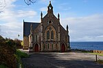
Gairloch Free Church Of Scotland 57°43′13″N 5°41′14″W / 57.720184°N 5.687231°W / 57.720184; -5.687231 (Gairloch Free Church Of Scotland ) Category B 7886 Upload another image See more images
Letterewe House And Rear Service 57°41′07″N 5°26′17″W / 57.685283°N 5.438159°W / 57.685283; -5.438159 (Letterewe House And Rear Service ) Category C(S) 7890 Poolewe Bridge Over River Ewe 57°45′57″N 5°36′12″W / 57.765696°N 5.60342°W / 57.765696; -5.60342 (Poolewe Bridge Over River Ewe ) Category B 7899 Flowerdale Barn 57°42′50″N 5°40′13″W / 57.713973°N 5.670169°W / 57.713973; -5.670169 (Flowerdale Barn ) Category B 7884 Upload another image
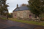
Gairloch The Old Police Station 57°43′42″N 5°41′27″W / 57.728429°N 5.690894°W / 57.728429; -5.690894 (Gairloch The Old Police Station ) Category C(S) 7888 Tollie (Clapper) Bridge Over Allt A'Pholl-Choire To Nw Of Tollie Farm 57°44′52″N 5°35′47″W / 57.747685°N 5.596329°W / 57.747685; -5.596329 (Tollie (Clapper) Bridge Over Allt A'Pholl-Choire To Nw Of Tollie Farm ) Category B 46976 Udrigle House 57°52′56″N 5°33′03″W / 57.882245°N 5.550953°W / 57.882245; -5.550953 (Udrigle House ) Category A 7902