| Name | Location | Date Listed | Grid Ref. [note 1] | Geo-coordinates | Notes | LB Number [note 2] | Image |
|---|
|
| 124 Land Street, Moorfield | | | | 57°32′28″N2°57′08″W / 57.54112°N 2.95231°W / 57.54112; -2.95231 (124 Land Street, Moorfield) | Category C(S) | 35639 |  |
| 104, 106, 108 Mid Street | | | | 57°32′24″N2°57′02″W / 57.540117°N 2.95068°W / 57.540117; -2.95068 (104, 106, 108 Mid Street) | Category B | 35653 | |
| Old Keith, Burial Ground And Site Of Former Parish Church | | | | 57°32′34″N2°57′30″W / 57.542655°N 2.958381°W / 57.542655; -2.958381 (Old Keith, Burial Ground And Site Of Former Parish Church) | Category B | 35660 | |
| 13 Regent Street, St Ronans | | | | 57°32′39″N2°57′29″W / 57.544103°N 2.958151°W / 57.544103; -2.958151 (13 Regent Street, St Ronans) | Category B | 35665 | |
| 15 Regent Street, Appin House And Garden Wall Abutting Regent Street And Wellington Terrace | | | | 57°32′39″N2°57′31″W / 57.544172°N 2.958521°W / 57.544172; -2.958521 (15 Regent Street, Appin House And Garden Wall Abutting Regent Street And Wellington Terrace) | Category B | 35666 | |
| Seafield Avenue, Holy Trinity Episcopal Church And Enclosing Walls | | | | 57°32′42″N2°57′10″W / 57.544889°N 2.952809°W / 57.544889; -2.952809 (Seafield Avenue, Holy Trinity Episcopal Church And Enclosing Walls) | Category B | 35678 | 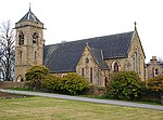 Upload another image
|
| 109, 111 Land Street | | | | 57°32′29″N2°57′06″W / 57.541303°N 2.95178°W / 57.541303; -2.95178 (109, 111 Land Street) | Category C(S) | 35632 | |
| 54, 56 Land Street And Garden Walls At South | | | | 57°32′18″N2°57′10″W / 57.538448°N 2.952758°W / 57.538448; -2.952758 (54, 56 Land Street And Garden Walls At South) | Category B | 35636 | |
| 134, 136 Land Street, (Former North Of Scotland Bank) | | | | 57°32′30″N2°57′08″W / 57.541533°N 2.952287°W / 57.541533; -2.952287 (134, 136 Land Street, (Former North Of Scotland Bank)) | Category B | 35640 | |
| 115, 117, Mid Street | | | | 57°32′25″N2°56′59″W / 57.540348°N 2.949767°W / 57.540348; -2.949767 (115, 117, Mid Street) | Category B | 35647 | |
| 5 Regent Street | | | | 57°32′38″N2°57′28″W / 57.543918°N 2.957662°W / 57.543918; -2.957662 (5 Regent Street) | Category C(S) | 35664 | |
| 33, 35 Regent Street | | | | 57°32′40″N2°57′36″W / 57.544573°N 2.960035°W / 57.544573; -2.960035 (33, 35 Regent Street) | Category C(S) | 35668 | |
| 2 Reidhaven Square And Garden Walls | | | | 57°32′17″N2°56′57″W / 57.538124°N 2.949275°W / 57.538124; -2.949275 (2 Reidhaven Square And Garden Walls) | Category B | 35674 | |
| 46, 48 Duff Street, (Entrance To No 48 Facing Mar Place) And Garden Wall To Mar Place | | | | 57°32′37″N2°57′52″W / 57.543643°N 2.964321°W / 57.543643; -2.964321 (46, 48 Duff Street, (Entrance To No 48 Facing Mar Place) And Garden Wall To Mar Place) | Category C(S) | 35630 | |
| Land Street, War Memorial | | | | 57°32′36″N2°57′06″W / 57.543236°N 2.951546°W / 57.543236; -2.951546 (Land Street, War Memorial) | Category B | 35634 | 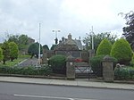 Upload another image
|
| Crooks Mill | | | | 57°33′01″N2°59′17″W / 57.550357°N 2.988142°W / 57.550357; -2.988142 (Crooks Mill) | Category B | 8701 | |
| 49, 51 Mid Street | | | | 57°32′17″N2°57′01″W / 57.538009°N 2.950291°W / 57.538009; -2.950291 (49, 51 Mid Street) | Category B | 35645 | |
| 98 Mid Street | | | | 57°32′23″N2°57′02″W / 57.539822°N 2.950505°W / 57.539822; -2.950505 (98 Mid Street) | Category C(S) | 35652 | |
| 138, 140 Mid Street, The Institute | | | | 57°32′28″N2°57′01″W / 57.541064°N 2.950203°W / 57.541064; -2.950203 (138, 140 Mid Street, The Institute) | Category B | 35655 |  Upload another image
|
| 176, 178, 180 Mid Street | | | | 57°32′32″N2°57′00″W / 57.542341°N 2.950019°W / 57.542341; -2.950019 (176, 178, 180 Mid Street) | Category B | 35656 | |
| 37, 39 Regent Street | | | | 57°32′41″N2°57′37″W / 57.544634°N 2.960287°W / 57.544634; -2.960287 (37, 39 Regent Street) | Category C(S) | 35669 | |
| 14 Chapel Street | | | | 57°32′19″N2°57′13″W / 57.538479°N 2.953494°W / 57.538479; -2.953494 (14 Chapel Street) | Category C(S) | 35628 | |
| 143, 145 Land Street And 14 Union Street | | | | 57°32′33″N2°57′06″W / 57.542527°N 2.951545°W / 57.542527; -2.951545 (143, 145 Land Street And 14 Union Street) | Category C(S) | 35633 | |
| 166 Land Street And 16 Union Street | | | | 57°32′33″N2°57′07″W / 57.542623°N 2.951881°W / 57.542623; -2.951881 (166 Land Street And 16 Union Street) | Category B | 35643 | |
| Old Keith, Bridge Over River Isla | | | | 57°32′37″N2°57′28″W / 57.543647°N 2.957855°W / 57.543647; -2.957855 (Old Keith, Bridge Over River Isla) | Category A | 35661 |  Upload another image
|
| 1, 3 Regent Street | | | | 57°32′38″N2°57′27″W / 57.543874°N 2.95751°W / 57.543874; -2.95751 (1, 3 Regent Street) | Category C(S) | 35663 | |
| 16, 18 Regent Street | | | | 57°32′39″N2°57′35″W / 57.544189°N 2.959858°W / 57.544189; -2.959858 (16, 18 Regent Street) | Category C(S) | 35671 | |
| 7, 9 Chapel Street, Den Mar And Crimond | | | | 57°32′19″N2°57′07″W / 57.538633°N 2.952028°W / 57.538633; -2.952028 (7, 9 Chapel Street, Den Mar And Crimond) | Category C(S) | 35624 |  Upload another image
|
| 12 Chapel Street | | | | 57°32′19″N2°57′12″W / 57.538526°N 2.953228°W / 57.538526; -2.953228 (12 Chapel Street) | Category C(S) | 35627 | |
| Church Road, St Rufus Church (Church Of Scotland), Enclosing Walls And Gatepiers | | | | 57°32′37″N2°57′15″W / 57.543729°N 2.954099°W / 57.543729; -2.954099 (Church Road, St Rufus Church (Church Of Scotland), Enclosing Walls And Gatepiers) | Category A | 35629 |  Upload another image
|
| 86 Land Street, Cuthill Lea | | | | 57°32′23″N2°57′09″W / 57.539771°N 2.952425°W / 57.539771; -2.952425 (86 Land Street, Cuthill Lea) | Category B | 35637 | |
| Auchindachy Bridge Over River Isla | | | | 57°30′49″N2°59′28″W / 57.513656°N 2.991189°W / 57.513656; -2.991189 (Auchindachy Bridge Over River Isla) | Category B | 8700 | |
| 88, 90, 92 Land Street, Chapel House | | | | 57°32′24″N2°57′09″W / 57.539934°N 2.952362°W / 57.539934; -2.952362 (88, 90, 92 Land Street, Chapel House) | Category C(S) | 35638 | |
| 168, 170 Land Street | | | | 57°32′34″N2°57′07″W / 57.542856°N 2.951904°W / 57.542856; -2.951904 (168, 170 Land Street) | Category C(S) | 35644 | |
| 161, 163 Mid Street, Clydesdale Bank | | | | 57°32′30″N2°56′58″W / 57.541751°N 2.949536°W / 57.541751; -2.949536 (161, 163 Mid Street, Clydesdale Bank) | Category C(S) | 35648 | |
| 2 Nelson Terrace | | | | 57°32′38″N2°57′38″W / 57.543752°N 2.960598°W / 57.543752; -2.960598 (2 Nelson Terrace) | Category B | 35659 | |
| 47, 49 Regent Street, 2 And 2A Station Road, Regent House | | | | 57°32′42″N2°57′39″W / 57.544864°N 2.960794°W / 57.544864; -2.960794 (47, 49 Regent Street, 2 And 2A Station Road, Regent House) | Category B | 35670 | |
| 28, 30 Regent Street And Return Elevation To Regent Square, Fife Arms Hotel | | | | 57°32′40″N2°57′38″W / 57.544425°N 2.960632°W / 57.544425; -2.960632 (28, 30 Regent Street And Return Elevation To Regent Square, Fife Arms Hotel) | Category B | 35672 |  Upload another image
|
| 36 Regent Street And 4, 5 Regent Square, Grampian Hotel (Formerly Gordon Arms Hotel) | | | | 57°32′41″N2°57′43″W / 57.544658°N 2.961925°W / 57.544658; -2.961925 (36 Regent Street And 4, 5 Regent Square, Grampian Hotel (Formerly Gordon Arms Hotel)) | Category C(S) | 35673 | |
| 17 Reidhaven Square | | | | 57°32′19″N2°57′05″W / 57.538729°N 2.951262°W / 57.538729; -2.951262 (17 Reidhaven Square) | Category B | 35676 | |
| 22, 23 Reidhaven Square, The Crown Inn And 53, 55 Mid Street | | | | 57°32′19″N2°57′00″W / 57.538738°N 2.950109°W / 57.538738; -2.950109 (22, 23 Reidhaven Square, The Crown Inn And 53, 55 Mid Street) | Category C(S) | 35677 | |
| Seafield Avenue, Strathisla Distillery | | | | 57°32′48″N2°57′18″W / 57.54666°N 2.954927°W / 57.54666; -2.954927 (Seafield Avenue, Strathisla Distillery) | Category A | 35679 | 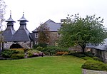 Upload another image
|
| Chapel Street, Roman Catholic Church Of St Thomas And Presbytery | | | | 57°32′19″N2°57′16″W / 57.53867°N 2.954384°W / 57.53867; -2.954384 (Chapel Street, Roman Catholic Church Of St Thomas And Presbytery) | Category A | 35623 | 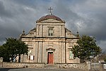 Upload another image
|
| 140 Land Street | | | | 57°32′30″N2°57′08″W / 57.541633°N 2.952123°W / 57.541633; -2.952123 (140 Land Street) | Category C(S) | 35641 | |
| 162, 164 Land Street | | | | 57°32′33″N2°57′07″W / 57.54247°N 2.951894°W / 57.54247; -2.951894 (162, 164 Land Street) | Category C(S) | 35642 | |
| 56-66 (Even Nos) Mid Street And 20, 21 Reidhaven Square | | | | 57°32′19″N2°57′02″W / 57.538734°N 2.950661°W / 57.538734; -2.950661 (56-66 (Even Nos) Mid Street And 20, 21 Reidhaven Square) | Category B | 35650 | |
| 43 Moss Street | | | | 57°32′17″N2°56′55″W / 57.537959°N 2.948552°W / 57.537959; -2.948552 (43 Moss Street) | Category B | 35657 | |
| 45 Moss Street | | | | 57°32′17″N2°56′55″W / 57.538103°N 2.948473°W / 57.538103; -2.948473 (45 Moss Street) | Category B | 35658 | |
| 29, 31 Regent Street | | | | 57°32′40″N2°57′35″W / 57.544476°N 2.959832°W / 57.544476; -2.959832 (29, 31 Regent Street) | Category C(S) | 35667 | |
| 8 Reidhaven Square And 50-54 (Even Nos) Mid Street | | | | 57°32′17″N2°57′03″W / 57.538193°N 2.95083°W / 57.538193; -2.95083 (8 Reidhaven Square And 50-54 (Even Nos) Mid Street) | Category B | 35675 | |
| 13, 15 Chapel Street | | | | 57°32′19″N2°57′10″W / 57.538691°N 2.952697°W / 57.538691; -2.952697 (13, 15 Chapel Street) | Category C(S) | 35626 | |
| Crooksmill Bridge Over Forgie Burn | | | | 57°33′02″N2°59′17″W / 57.550547°N 2.98798°W / 57.550547; -2.98798 (Crooksmill Bridge Over Forgie Burn) | Category C(S) | 8702 | |
| 86 Mid Street, Seafield Arms Hotel | | | | 57°32′22″N2°57′02″W / 57.539409°N 2.950428°W / 57.539409; -2.950428 (86 Mid Street, Seafield Arms Hotel) | Category B | 35651 | |
| 130, 132 Mid Street, The Post Office | | | | 57°32′27″N2°57′01″W / 57.540803°N 2.95028°W / 57.540803; -2.95028 (130, 132 Mid Street, The Post Office) | Category B | 35654 | |
| 2 Regent Square And Garden Walls | | | | 57°32′39″N2°57′41″W / 57.544213°N 2.961395°W / 57.544213; -2.961395 (2 Regent Square And Garden Walls) | Category B | 35662 | |
| Union Bridge Over River Isla | | | | 57°32′37″N2°57′25″W / 57.543545°N 2.957034°W / 57.543545; -2.957034 (Union Bridge Over River Isla) | Category C(S) | 35682 | 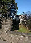 Upload another image
|
| 42 Land Street, Former Steading At Rear And Garden Wall | | | | 57°32′16″N2°57′10″W / 57.537855°N 2.952759°W / 57.537855; -2.952759 (42 Land Street, Former Steading At Rear And Garden Wall) | Category C(S) | 35635 | |
| Newmill, Mill Of Newmill | | | | 57°33′22″N2°56′23″W / 57.556144°N 2.939667°W / 57.556144; -2.939667 (Newmill, Mill Of Newmill) | Category C(S) | 8704 | |
| Newmill, War Memorial Clock Tower | | | | 57°33′33″N2°56′44″W / 57.559289°N 2.945614°W / 57.559289; -2.945614 (Newmill, War Memorial Clock Tower) | Category C(S) | 8705 | 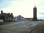 Upload another image
See more images |
| 105, 107 Mid Street | | | | 57°32′24″N2°56′59″W / 57.54006°N 2.94986°W / 57.54006; -2.94986 (105, 107 Mid Street) | Category B | 35646 | |
| Mid Street, North Church Of Scotland | | | | 57°32′34″N2°56′57″W / 57.542886°N 2.949165°W / 57.542886; -2.949165 (Mid Street, North Church Of Scotland) | Category B | 35649 | 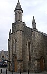 Upload another image
|
| Station Road, Linn Bridge Over River Isla | | | | 57°32′49″N2°57′23″W / 57.546829°N 2.956435°W / 57.546829; -2.956435 (Station Road, Linn Bridge Over River Isla) | Category B | 35680 | |
| 11 Chapel Street, Cuthill House | | | | 57°32′19″N2°57′08″W / 57.538632°N 2.952211°W / 57.538632; -2.952211 (11 Chapel Street, Cuthill House) | Category B | 35625 |  Upload another image
|
| Edintore House | | | | 57°30′01″N2°57′27″W / 57.500279°N 2.957586°W / 57.500279; -2.957586 (Edintore House) | Category B | 8703 | |


