Name Location Date Listed Grid Ref. [note 1] Geo-coordinates Notes LB Number [note 2] Image Hawthorn and 25 Ferry Road Beauly 57°28′59″N 4°27′30″W / 57.483016°N 4.45844°W / 57.483016; -4.45844 (Hawthorn and 25 Ferry Road ) Category C(S) 7107 29 Ferry Road (Cherry Tree Cottage) Beauly 57°28′58″N 4°27′29″W / 57.482898°N 4.458031°W / 57.482898; -4.458031 (29 Ferry Road (Cherry Tree Cottage) ) Category C(S) 7109 Lovat Arms Hotel Beauly 57°28′59″N 4°27′40″W / 57.482936°N 4.461154°W / 57.482936; -4.461154 (Lovat Arms Hotel ) Category B 7130 Upload another image
52, 54 High Street Beauly 57°29′04″N 4°27′34″W / 57.484515°N 4.459425°W / 57.484515; -4.459425 (52, 54 High Street ) Category B 7133 1 Priory Court, The Square Beauly 57°29′03″N 4°27′31″W / 57.484174°N 4.458484°W / 57.484174; -4.458484 (1 Priory Court, The Square ) Category C(S) 7134 Matheson's Bakery, The Square Beauly 57°29′00″N 4°27′34″W / 57.483419°N 4.459385°W / 57.483419; -4.459385 (Matheson's Bakery, The Square ) Category C(S) 7139 St Mary's Roman Catholic Church, Burial Ground and Presbytery Beauly 57°29′10″N 4°27′28″W / 57.486166°N 4.457684°W / 57.486166; -4.457684 (St Mary's Roman Catholic Church, Burial Ground and Presbytery ) Category B 7111 Upload another image See more images
Fasnakyle Power Station, Glen Affric Hydro Electric Scheme By Cannich 57°19′34″N 4°47′39″W / 57.326087°N 4.794209°W / 57.326087; -4.794209 (Fasnakyle Power Station, Glen Affric Hydro Electric Scheme ) Category A 7118 Upload another image See more images
Old Burial Ground Kilmorack 57°27′49″N 4°30′48″W / 57.463746°N 4.513275°W / 57.463746; -4.513275 (Old Burial Ground ) Category C(S) 7123 Gate Lodge, Aigas House Aigas 57°26′20″N 4°33′53″W / 57.438857°N 4.564843°W / 57.438857; -4.564843 (Gate Lodge, Aigas House ) Category C(S) 7126 Upload another image
4-12(inclusive nos) Priory Court, The Square Beauly 57°29′02″N 4°27′31″W / 57.483938°N 4.458619°W / 57.483938; -4.458619 (4-12(inclusive nos) Priory Court, The Square ) Category C(S) 7136 Knockfin House By Tomich 57°18′03″N 4°49′26″W / 57.300954°N 4.823798°W / 57.300954; -4.823798 (Knockfin House ) Category C(S) 7101 Ardmor House, The Square Beauly 57°29′00″N 4°27′34″W / 57.483336°N 4.459496°W / 57.483336; -4.459496 (Ardmor House, The Square ) Category C(S) 7104 27 Ferry Road (Roselea) Beauly 57°28′59″N 4°27′29″W / 57.482931°N 4.458184°W / 57.482931; -4.458184 (27 Ferry Road (Roselea) ) Category C(S) 7108 Netherdale Beauly 57°28′52″N 4°27′52″W / 57.480995°N 4.464377°W / 57.480995; -4.464377 (Netherdale ) Category C(S) 7110 Well House Farm By Beauly 57°29′29″N 4°28′02″W / 57.491424°N 4.467282°W / 57.491424; -4.467282 (Well House Farm ) Category B 7112 Mill Cannich 57°20′46″N 4°45′22″W / 57.346134°N 4.756102°W / 57.346134; -4.756102 (Mill ) Category B 7116 Glen Affric Lodge Glen Affric 57°15′39″N 5°00′45″W / 57.260765°N 5.012421°W / 57.260765; -5.012421 (Glen Affric Lodge ) Category A 7121 Upload another image See more images
Old Manse and Steading Kilmorack 57°27′53″N 4°30′52″W / 57.464632°N 4.514353°W / 57.464632; -4.514353 (Old Manse and Steading ) Category B 7124 Monar Dam And Deanie Tunnel Intake Tower, Glen Affric Hydro Electric Scheme Glen Strathfarrar 57°24′32″N 4°59′35″W / 57.408816°N 4.993134°W / 57.408816; -4.993134 (Monar Dam And Deanie Tunnel Intake Tower, Glen Affric Hydro Electric Scheme ) Category B 51702 Upload another image See more images
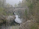
Comar Cannich 57°20′30″N 4°46′18″W / 57.341739°N 4.771629°W / 57.341739; -4.771629 (Comar ) Category C(S) 7113 Cannich Church Of Scotland Cannich 57°20′47″N 4°46′01″W / 57.346333°N 4.767072°W / 57.346333; -4.767072 (Cannich Church Of Scotland ) Category C(S) 7114 Marydale Roman Catholic Church, Presbytery and Former School Cannich 57°20′45″N 4°45′30″W / 57.345826°N 4.75824°W / 57.345826; -4.75824 (Marydale Roman Catholic Church, Presbytery and Former School ) Category B 7115 Fasnakyle Bridge Over River Glass By Cannich 57°19′27″N 4°47′30″W / 57.324259°N 4.791561°W / 57.324259; -4.791561 (Fasnakyle Bridge Over River Glass ) Category B 7119 Upload another image See more images
Campbell and Co, High Street Beauly 57°28′58″N 4°27′37″W / 57.482898°N 4.460334°W / 57.482898; -4.460334 (Campbell and Co, High Street ) Category C(S) 7131 Upload another image
2 and 3 Priory Court, The Square Beauly 57°29′03″N 4°27′31″W / 57.484073°N 4.458578°W / 57.484073; -4.458578 (2 and 3 Priory Court, The Square ) Category C(S) 7135 Market Cross, The Square Beauly 57°29′03″N 4°27′33″W / 57.484145°N 4.459066°W / 57.484145; -4.459066 (Market Cross, The Square ) Category B 49635 Upload another image See more images
Old Parish Church and Burial Ground Kilmorack 57°27′51″N 4°30′42″W / 57.46418°N 4.511787°W / 57.46418; -4.511787 (Old Parish Church and Burial Ground ) Category B 7122 Upload another image See more images
Beauly Priory Beauly 57°29′05″N 4°27′28″W / 57.484647°N 4.457732°W / 57.484647; -4.457732 (Beauly Priory ) Category A 7129 Upload another image See more images
Former School and Schoolhouse Struy 57°25′05″N 4°40′09″W / 57.417959°N 4.669276°W / 57.417959; -4.669276 (Former School and Schoolhouse ) Category B 7103 Upload another image
Culloch House, The Square Beauly 57°29′00″N 4°27′35″W / 57.483236°N 4.459589°W / 57.483236; -4.459589 (Culloch House, The Square ) Category C(S) 7105 Glassburn Strathglass 57°22′17″N 4°42′51″W / 57.371505°N 4.714305°W / 57.371505; -4.714305 (Glassburn ) Category B 7120 Former Free Church and Enclosing Walls Wester Balblair 57°28′15″N 4°29′18″W / 57.470928°N 4.488266°W / 57.470928; -4.488266 (Former Free Church and Enclosing Walls ) Category C(S) 7128 Upload another image See more images
Commercial Hotel, Commercial Street Beauly 57°29′02″N 4°27′32″W / 57.483788°N 4.458925°W / 57.483788; -4.458925 (Commercial Hotel, Commercial Street ) Category C(S) 7137 Smithy Cottage Crask of Aigas 57°26′41″N 4°33′19″W / 57.44473°N 4.555354°W / 57.44473; -4.555354 (Smithy Cottage ) Category C(S) 49020 Eileanaigas House Eilean Aigas 57°26′28″N 4°33′09″W / 57.441199°N 4.552625°W / 57.441199; -4.552625 (Eileanaigas House ) Category B 7117 Upload another image
Druim Cottage Crask of Aigas 57°26′44″N 4°33′18″W / 57.44544°N 4.554904°W / 57.44544; -4.554904 (Druim Cottage ) Category C(S) 7127 Mullardoch Dam, Glen Affric Hydro Electric Scheme Glen Cannich 57°20′17″N 4°57′18″W / 57.338038°N 4.955107°W / 57.338038; -4.955107 (Mullardoch Dam, Glen Affric Hydro Electric Scheme ) Category B 51703 Upload another image See more images
Bank Of Scotland Beauly 57°29′01″N 4°27′38″W / 57.483497°N 4.460474°W / 57.483497; -4.460474 (Bank Of Scotland ) Category B 7106 Upload another image
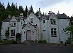
Aigas House (now Aigas Field Centre ) Aigas 57°26′14″N 4°34′03″W / 57.437183°N 4.567609°W / 57.437183; -4.567609 (Aigas House (now Aigas Field Centre) ) Category B 7125 Upload another image
3, 4 High Street Beauly 57°29′01″N 4°27′36″W / 57.483739°N 4.460023°W / 57.483739; -4.460023 (3, 4 High Street ) Category C(S) 7132 Beaufort House, The Square Beauly 57°29′01″N 4°27′33″W / 57.483511°N 4.459291°W / 57.483511; -4.459291 (Beaufort House, The Square ) Category C(S) 7138 Corf House By Lovat Bridge 57°28′11″N 4°28′36″W / 57.46968°N 4.47679°W / 57.46968; -4.47679 (Corf House ) Category B 7102