Name Location Date Listed Grid Ref. [note 1] Geo-coordinates Notes LB Number [note 2] Image Boiden 56°02′18″N 4°38′28″W / 56.038383°N 4.641102°W / 56.038383; -4.641102 (Boiden ) Category C(S) 43960 Burnfoot 56°01′40″N 4°37′57″W / 56.027734°N 4.632606°W / 56.027734; -4.632606 (Burnfoot ) Category C(S) 43961 Gallowhill 56°03′17″N 4°38′48″W / 56.054638°N 4.64676°W / 56.054638; -4.64676 (Gallowhill ) Category C(S) 43967 Low Aldochlay, Rowanbank With Railings 56°05′13″N 4°38′14″W / 56.086957°N 4.637242°W / 56.086957; -4.637242 (Low Aldochlay, Rowanbank With Railings ) Category C(S) 43972 Luss Village, The Bungalow Cleveland Bank 56°06′05″N 4°38′14″W / 56.101515°N 4.637353°W / 56.101515; -4.637353 (Luss Village, The Bungalow Cleveland Bank ) Category B 43976 Luss Village, Hall House And Luss Hall With Boundary Wall 56°06′03″N 4°38′19″W / 56.100814°N 4.638608°W / 56.100814; -4.638608 (Luss Village, Hall House And Luss Hall With Boundary Wall ) Category C(S) 43980 Luss Village, Lochview and Pier Cottage With Boundary Wall 56°06′07″N 4°38′15″W / 56.101881°N 4.637474°W / 56.101881; -4.637474 (Luss Village, Lochview and Pier Cottage With Boundary Wall ) Category B 43981 Upload another image
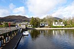
Port Of Rossdhu, Mill Bridge 56°04′09″N 4°38′40″W / 56.069105°N 4.644442°W / 56.069105; -4.644442 (Port Of Rossdhu, Mill Bridge ) Category C(S) 43990 Rossbank With Outbuildings 56°01′42″N 4°38′33″W / 56.028267°N 4.642546°W / 56.028267; -4.642546 (Rossbank With Outbuildings ) Category B 43993 Rossdhu Estate, Walled Garden With Glasshouses 56°03′41″N 4°37′59″W / 56.061301°N 4.633175°W / 56.061301; -4.633175 (Rossdhu Estate, Walled Garden With Glasshouses ) Category B 43997 Shemore With Outbuildings 56°03′37″N 4°39′31″W / 56.060253°N 4.658583°W / 56.060253; -4.658583 (Shemore With Outbuildings ) Category B 43998 Rossdhu Estate, South Lodge And Gate With Railings 56°02′46″N 4°38′45″W / 56.046066°N 4.645803°W / 56.046066; -4.645803 (Rossdhu Estate, South Lodge And Gate With Railings ) Category A 19698 Upload another image
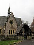
Luss Village, St Mackessog's Church (Church Of Scotland) With Burial Ground, Lych Gates And Boundary Wall 56°06′01″N 4°38′12″W / 56.100362°N 4.636647°W / 56.100362; -4.636647 (Luss Village, St Mackessog's Church (Church Of Scotland) With Burial Ground, Lych Gates And Boundary Wall ) Category B 14430 Upload another image
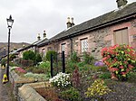
Luss Village, Yewbank and Lonaigview 56°06′06″N 4°38′16″W / 56.101579°N 4.637727°W / 56.101579; -4.637727 (Luss Village, Yewbank and Lonaigview ) Category B 14433 Luss Village, Crescent Cottage 56°06′04″N 4°38′19″W / 56.101092°N 4.638643°W / 56.101092; -4.638643 (Luss Village, Crescent Cottage ) Category B 14446 Rossdhu Estate, Ross Lodge With Gatepiers And Railings 56°03′27″N 4°38′43″W / 56.057432°N 4.645168°W / 56.057432; -4.645168 (Rossdhu Estate, Ross Lodge With Gatepiers And Railings ) Category B 14455 High Aldochlay, 2 Roselea Cottages 56°05′16″N 4°38′18″W / 56.087777°N 4.638375°W / 56.087777; -4.638375 (High Aldochlay, 2 Roselea Cottages ) Category C(S) 14460 Luss Village, Elmbank 56°06′04″N 4°38′13″W / 56.101202°N 4.636865°W / 56.101202; -4.636865 (Luss Village, Elmbank ) Category C(S) 14466 Upload another image
Luss Village, Rose Cottage and The Sheiling 56°06′04″N 4°38′17″W / 56.101204°N 4.638007°W / 56.101204; -4.638007 (Luss Village, Rose Cottage and The Sheiling ) Category B 43982 Luss Village, Thistle Cottage 56°06′08″N 4°38′15″W / 56.102105°N 4.637522°W / 56.102105; -4.637522 (Luss Village, Thistle Cottage ) Category C(S) 43984 Upload another image
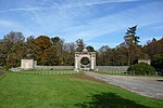
Luss Village, War Memorial 56°06′04″N 4°38′18″W / 56.101142°N 4.638405°W / 56.101142; -4.638405 (Luss Village, War Memorial ) Category C(S) 43986 Upload another image
Ross Arden 56°05′05″N 4°38′08″W / 56.084663°N 4.635622°W / 56.084663; -4.635622 (Ross Arden ) Category C(S) 43992 Millburn Cottage And Mill 56°06′00″N 4°38′37″W / 56.09998°N 4.643568°W / 56.09998; -4.643568 (Millburn Cottage And Mill ) Category B 19700 Luss Village, Luss General Store 56°06′07″N 4°38′15″W / 56.101881°N 4.637474°W / 56.101881; -4.637474 (Luss Village, Luss General Store ) Category C(S) 14431 Auchentullich Namoin With Outbuildings 56°02′19″N 4°38′42″W / 56.038571°N 4.644888°W / 56.038571; -4.644888 (Auchentullich Namoin With Outbuildings ) Category C(S) 43958 Bandry Cottages With Railings 56°04′50″N 4°38′23″W / 56.080604°N 4.639668°W / 56.080604; -4.639668 (Bandry Cottages With Railings ) Category B 43959 Camstradden House With Sundial, Boundary Wall And Gatepiers 56°05′37″N 4°38′17″W / 56.093714°N 4.638186°W / 56.093714; -4.638186 (Camstradden House With Sundial, Boundary Wall And Gatepiers ) Category B 43962 High Aldochlay, South Cottage And North Cottage 56°05′16″N 4°38′17″W / 56.087786°N 4.63799°W / 56.087786; -4.63799 (High Aldochlay, South Cottage And North Cottage ) Category B 43969 Luss Village, Colquhoun Arms Hotel 56°06′02″N 4°38′29″W / 56.100487°N 4.641287°W / 56.100487; -4.641287 (Luss Village, Colquhoun Arms Hotel ) Category C(S) 43978 Nether Ross 56°01′53″N 4°38′16″W / 56.031309°N 4.637746°W / 56.031309; -4.637746 (Nether Ross ) Category C(S) 43989 Rossdhu Estate, Dairy Dwelling 56°03′32″N 4°37′59″W / 56.058905°N 4.633012°W / 56.058905; -4.633012 (Rossdhu Estate, Dairy Dwelling ) Category C(S) 43996 Luss Village, Avonlea and Ivy Bank 56°06′05″N 4°38′16″W / 56.101335°N 4.637807°W / 56.101335; -4.637807 (Luss Village, Avonlea and Ivy Bank ) Category B 19697 Upload another image
Luss Village, Mostyn Cottage 56°06′05″N 4°38′17″W / 56.101439°N 4.637959°W / 56.101439; -4.637959 (Luss Village, Mostyn Cottage ) Category B 14435 Upload another image
Rossdhu Estate, Icehouse 56°04′16″N 4°38′02″W / 56.071092°N 4.633924°W / 56.071092; -4.633924 (Rossdhu Estate, Icehouse ) Category C(S) 14450 Luss Village, The Anchorage And Lomondbank 56°06′05″N 4°38′14″W / 56.101515°N 4.637353°W / 56.101515; -4.637353 (Luss Village, The Anchorage And Lomondbank ) Category B 14465 Upload another image
Glen Luss, Edentaggart Bridge 56°06′38″N 4°41′36″W / 56.110677°N 4.693396°W / 56.110677; -4.693396 (Glen Luss, Edentaggart Bridge ) Category C(S) 14468 Rossdhu House With Walled Garden 56°04′12″N 4°38′00″W / 56.069875°N 4.633246°W / 56.069875; -4.633246 (Rossdhu House With Walled Garden ) Category A 14469 Upload another image See more images
Halfton Cottage 56°05′46″N 4°38′30″W / 56.096074°N 4.641708°W / 56.096074; -4.641708 (Halfton Cottage ) Category C(S) 43968 Luss Village, Church Of Scotland Manse With Boundary Wall 56°06′03″N 4°38′14″W / 56.100739°N 4.637091°W / 56.100739; -4.637091 (Luss Village, Church Of Scotland Manse With Boundary Wall ) Category C(S) 43977 Luss Village, Shore Cottage 56°06′03″N 4°38′10″W / 56.100786°N 4.636161°W / 56.100786; -4.636161 (Luss Village, Shore Cottage ) Category C(S) 43983 Upload another image
Luss Village, Holly Cottage 56°06′03″N 4°38′22″W / 56.100958°N 4.639454°W / 56.100958; -4.639454 (Luss Village, Holly Cottage ) Category B 14425 Luss Village, Tigh A Mhaoir 56°06′04″N 4°38′21″W / 56.101029°N 4.639073°W / 56.101029; -4.639073 (Luss Village, Tigh A Mhaoir ) Category B 14426 Upload another image
Luss Village, Fernlea and Ivy Cottage 56°06′05″N 4°38′17″W / 56.101301°N 4.638126°W / 56.101301; -4.638126 (Luss Village, Fernlea and Ivy Cottage ) Category B 14444 Low Aldochlay, Braeside With Gates And Railings 56°05′12″N 4°38′14″W / 56.086744°N 4.637114°W / 56.086744; -4.637114 (Low Aldochlay, Braeside With Gates And Railings ) Category B 14459 Crosskeys Cottage 56°01′49″N 4°40′06″W / 56.030343°N 4.66842°W / 56.030343; -4.66842 (Crosskeys Cottage ) Category C(S) 43964 Low Aldochlay, Rose Cottage 56°05′11″N 4°38′17″W / 56.086329°N 4.638035°W / 56.086329; -4.638035 (Low Aldochlay, Rose Cottage ) Category C(S) 43971 Low Bridge 56°02′08″N 4°38′24″W / 56.035637°N 4.640032°W / 56.035637; -4.640032 (Low Bridge ) Category B 43975 Luss Village, Tighnafois 56°06′04″N 4°38′12″W / 56.101018°N 4.636627°W / 56.101018; -4.636627 (Luss Village, Tighnafois ) Category C(S) 43985 Muirland Cottage 56°02′38″N 4°39′18″W / 56.043899°N 4.655016°W / 56.043899; -4.655016 (Muirland Cottage ) Category C(S) 43987 Rossdhu Estate, Dairy Complex 56°03′32″N 4°37′58″W / 56.059027°N 4.632763°W / 56.059027; -4.632763 (Rossdhu Estate, Dairy Complex ) Category B 43995 Bannachra Castle 56°01′22″N 4°39′39″W / 56.022894°N 4.660828°W / 56.022894; -4.660828 (Bannachra Castle ) Category B 19699 Luss Village, Sunnyside 56°06′06″N 4°38′15″W / 56.101764°N 4.637499°W / 56.101764; -4.637499 (Luss Village, Sunnyside ) Category B 14432 Upload another image
Luss Village, Roselea 56°06′04″N 4°38′18″W / 56.101236°N 4.638218°W / 56.101236; -4.638218 (Luss Village, Roselea ) Category B 14445 Luss Village, Laurel Cottage and Ravenslea 56°06′04″N 4°38′17″W / 56.10114°N 4.638083°W / 56.10114; -4.638083 (Luss Village, Laurel Cottage and Ravenslea ) Category B 14463 Glen Luss Chapel Memorial 56°06′39″N 4°40′37″W / 56.110783°N 4.676948°W / 56.110783; -4.676948 (Glen Luss Chapel Memorial ) Category C(S) 14464 Duchlage Farmhouse With Steading And Paddock Fencing 56°02′54″N 4°39′02″W / 56.048463°N 4.650512°W / 56.048463; -4.650512 (Duchlage Farmhouse With Steading And Paddock Fencing ) Category C(S) 43966 Low Aldochlay Cottage 56°05′11″N 4°38′14″W / 56.08629°N 4.637325°W / 56.08629; -4.637325 (Low Aldochlay Cottage ) Category C(S) 43973 Luss Village, Dell Cottage 56°06′01″N 4°38′17″W / 56.100215°N 4.638052°W / 56.100215; -4.638052 (Luss Village, Dell Cottage ) Category C(S) 43979 Muirland School With Wall And Railings 56°02′44″N 4°39′11″W / 56.045614°N 4.653047°W / 56.045614; -4.653047 (Muirland School With Wall And Railings ) Category B 43988 Luss Village, Lonaigbank and Marlyn 56°06′06″N 4°38′16″W / 56.10166°N 4.637733°W / 56.10166; -4.637733 (Luss Village, Lonaigbank and Marlyn ) Category B 14434 Upload another image
Rossdhu Estate, St Mary's Chapel With Grave Monuments 56°04′15″N 4°38′02″W / 56.070966°N 4.633899°W / 56.070966; -4.633899 (Rossdhu Estate, St Mary's Chapel With Grave Monuments ) Category B 14449 Culag Old Military Bridge 56°08′15″N 4°39′36″W / 56.137474°N 4.660114°W / 56.137474; -4.660114 (Culag Old Military Bridge ) Category C(S) 14462 Glen Luss, Chapel Hill Bridge 56°06′42″N 4°41′07″W / 56.111576°N 4.685142°W / 56.111576; -4.685142 (Glen Luss, Chapel Hill Bridge ) Category B 14467 Ardallie 56°05′17″N 4°38′30″W / 56.088091°N 4.641756°W / 56.088091; -4.641756 (Ardallie ) Category C(S) 43957 Carn Dearg 56°06′09″N 4°38′33″W / 56.102473°N 4.642565°W / 56.102473; -4.642565 (Carn Dearg ) Category C(S) 43963 Inchgalbraith, Galbraith Castle 56°04′40″N 4°37′19″W / 56.077807°N 4.622055°W / 56.077807; -4.622055 (Inchgalbraith, Galbraith Castle ) Category C(S) 43970 Low Aldochlay, Cottage 56°05′11″N 4°38′14″W / 56.086519°N 4.637131°W / 56.086519; -4.637131 (Low Aldochlay, Cottage ) Category C(S) 43974 Rossdhu Estate, Coach House 56°04′13″N 4°38′08″W / 56.070192°N 4.63563°W / 56.070192; -4.63563 (Rossdhu Estate, Coach House ) Category B 43994 Springbank Cottage 56°02′41″N 4°39′11″W / 56.044807°N 4.652959°W / 56.044807; -4.652959 (Springbank Cottage ) Category C(S) 43999 Rossdhu Estate, Laundry 56°04′14″N 4°38′07″W / 56.070485°N 4.635393°W / 56.070485; -4.635393 (Rossdhu Estate, Laundry ) Category B 14452 Darroch Cottage 56°05′48″N 4°38′40″W / 56.096795°N 4.644572°W / 56.096795; -4.644572 (Darroch Cottage ) Category C(S) 43965 Port Of Rossdhu, Mill 56°04′09″N 4°38′38″W / 56.069288°N 4.643876°W / 56.069288; -4.643876 (Port Of Rossdhu, Mill ) Category C(S) 43991 Luss Village, Alderdale With Boundary Wall 56°06′03″N 4°38′24″W / 56.100931°N 4.63987°W / 56.100931; -4.63987 (Luss Village, Alderdale With Boundary Wall ) Category C(S) 14447 Rossdhu Castle 56°04′13″N 4°38′05″W / 56.070281°N 4.634833°W / 56.070281; -4.634833 (Rossdhu Castle ) Category B 14448 Rossdhu Lodge, North Lodge With Gatepiers And Railings 56°04′24″N 4°38′20″W / 56.073395°N 4.638838°W / 56.073395; -4.638838 (Rossdhu Lodge, North Lodge With Gatepiers And Railings ) Category B 14454 Inverbeg Bridge 56°08′43″N 4°39′58″W / 56.145337°N 4.665987°W / 56.145337; -4.665987 (Inverbeg Bridge ) Category C(S) 49637