Name Location Date Listed Grid Ref. [note 1] Geo-coordinates Notes LB Number [note 2] Image 110 And 112 North High Street 55°56′37″N 3°03′36″W / 55.943696°N 3.059967°W / 55.943696; -3.059967 (110 And 112 North High Street ) Category C(S) 38374 Station Road Links Coachworks 55°56′23″N 3°03′31″W / 55.939638°N 3.058543°W / 55.939638; -3.058543 (Station Road Links Coachworks ) Category B 38385 1-53 West Holmes Gardens, Odd Numbers 55°56′28″N 3°03′34″W / 55.941076°N 3.059527°W / 55.941076; -3.059527 (1-53 West Holmes Gardens, Odd Numbers ) Category B 38390 57-67 Odd Numbers And 68-104 Even Numbers West Holmes Gardens 55°56′30″N 3°03′35″W / 55.941658°N 3.059687°W / 55.941658; -3.059687 (57-67 Odd Numbers And 68-104 Even Numbers West Holmes Gardens ) Category C(S) 38391 2-14 West Holmes Gardens, Even Numbers 55°56′28″N 3°03′33″W / 55.941232°N 3.059083°W / 55.941232; -3.059083 (2-14 West Holmes Gardens, Even Numbers ) Category B 38392 22 And 24 West Holmes Gardens 55°56′29″N 3°03′34″W / 55.941328°N 3.059422°W / 55.941328; -3.059422 (22 And 24 West Holmes Gardens ) Category B 38394 26-64 West Holmes Gardens Even Numbers 55°56′30″N 3°03′36″W / 55.941538°N 3.0601°W / 55.941538; -3.0601 (26-64 West Holmes Gardens Even Numbers ) Category B 38395 1-8 Windsor Gardens, Consecutive Numbers 55°56′42″N 3°02′06″W / 55.944941°N 3.035055°W / 55.944941; -3.035055 (1-8 Windsor Gardens, Consecutive Numbers ) Category B 38397 24 Hercus Loan 55°56′32″N 3°03′30″W / 55.942317°N 3.05836°W / 55.942317; -3.05836 (24 Hercus Loan ) Category C(S) 38290 31 And 33 High Street 55°56′37″N 3°02′51″W / 55.943578°N 3.047507°W / 55.943578; -3.047507 (31 And 33 High Street ) Category B 38299 35, 37 And 39 High Street 55°56′37″N 3°02′52″W / 55.943693°N 3.047718°W / 55.943693; -3.047718 (35, 37 And 39 High Street ) Category C(S) 38300 58 And 60 High Street Rumours Corner Of Newbigging 55°56′34″N 3°02′53″W / 55.94288°N 3.048129°W / 55.94288; -3.048129 (58 And 60 High Street Rumours Corner Of Newbigging ) Category C(S) 38323 Linkfield Road Corner Of Millhill Loretto School Loretto Villa 55°56′43″N 3°02′38″W / 55.945218°N 3.043756°W / 55.945218; -3.043756 (Linkfield Road Corner Of Millhill Loretto School Loretto Villa ) Category B 38334 Linkfield Road Loretto School Mound 55°56′41″N 3°02′38″W / 55.944768°N 3.04384°W / 55.944768; -3.04384 (Linkfield Road Loretto School Mound ) Category C(S) 38336 Linkfield Road, 1-13 Albert Terrace (Consecutive Numbers) 55°56′43″N 3°02′08″W / 55.945315°N 3.035449°W / 55.945315; -3.035449 (Linkfield Road, 1-13 Albert Terrace (Consecutive Numbers) ) Category B 38344 Mall Avenue Moir Statue 55°56′31″N 3°03′16″W / 55.941901°N 3.05449°W / 55.941901; -3.05449 (Mall Avenue Moir Statue ) Category B 38346 North High Street North Esk Lodge Corner Of Eskside West 55°56′40″N 3°03′10″W / 55.944359°N 3.052844°W / 55.944359; -3.052844 (North High Street North Esk Lodge Corner Of Eskside West ) Category B 38366 4 Balcarres Road Formerly Bruntsfield Links Golfing Society 55°56′45″N 3°02′46″W / 55.945889°N 3.046192°W / 55.945889; -3.046192 (4 Balcarres Road Formerly Bruntsfield Links Golfing Society ) Category B 38248 11, 13 And 15 Bridge Street 55°56′34″N 3°03′20″W / 55.942899°N 3.055478°W / 55.942899; -3.055478 (11, 13 And 15 Bridge Street ) Category C(S) 38251 23 Bridge Street 55°56′35″N 3°03′21″W / 55.943075°N 3.055899°W / 55.943075; -3.055899 (23 Bridge Street ) Category C(S) 38253 26 Bridge Street 55°56′37″N 3°03′29″W / 55.943498°N 3.057928°W / 55.943498; -3.057928 (26 Bridge Street ) Category B 38263 3 And 5 Campie Lane 55°56′35″N 3°03′42″W / 55.943016°N 3.061661°W / 55.943016; -3.061661 (3 And 5 Campie Lane ) Category C(S) 38265 32 And 33 Eskside West And 1 Hercus Loan 55°56′31″N 3°03′24″W / 55.941981°N 3.056702°W / 55.941981; -3.056702 (32 And 33 Eskside West And 1 Hercus Loan ) Category C(S) 38285 79-81 North High Street, Volunteer Arms (Staggs) 55°56′39″N 3°03′26″W / 55.944223°N 3.057131°W / 55.944223; -3.057131 (79-81 North High Street, Volunteer Arms (Staggs) ) Category C(S) 51111 Windsor Gardens, St Anne's Convent 55°56′45″N 3°02′30″W / 55.94582°N 3.041579°W / 55.94582; -3.041579 (Windsor Gardens, St Anne's Convent ) Category B 38399 34 And 36 Ravensheugh Road 55°56′45″N 3°01′27″W / 55.945759°N 3.024252°W / 55.945759; -3.024252 (34 And 36 Ravensheugh Road ) Category B 38381 Stoneyhill 55°56′20″N 3°03′55″W / 55.939023°N 3.06525°W / 55.939023; -3.06525 (Stoneyhill ) Category B 38387 16-20 West Holmes Gardens, Even Numbers 55°56′30″N 3°03′33″W / 55.941545°N 3.059284°W / 55.941545; -3.059284 (16-20 West Holmes Gardens, Even Numbers ) Category B 38393 9-15 Windsor Gardens, Consecutive Numbers 55°56′42″N 3°02′11″W / 55.944966°N 3.036368°W / 55.944966; -3.036368 (9-15 Windsor Gardens, Consecutive Numbers ) Category B 38398 23-29 (Odd Nos) High Street 55°56′37″N 3°02′50″W / 55.943517°N 3.047233°W / 55.943517; -3.047233 (23-29 (Odd Nos) High Street ) Category B 38297 41 High Street Post Office 55°56′37″N 3°02′52″W / 55.943709°N 3.047911°W / 55.943709; -3.047911 (41 High Street Post Office ) Category B 38301 65-75 High Street Odd Numbers 55°56′35″N 3°02′57″W / 55.943034°N 3.049045°W / 55.943034; -3.049045 (65-75 High Street Odd Numbers ) Category C(S) 38310 129-135 High Street Odd Numbers 55°56′33″N 3°03′05″W / 55.942538°N 3.051418°W / 55.942538; -3.051418 (129-135 High Street Odd Numbers ) Category C(S) 38312 High Street Pinkie House Walled Garden 55°56′34″N 3°02′35″W / 55.942707°N 3.043129°W / 55.942707; -3.043129 (High Street Pinkie House Walled Garden ) Category B 38317 2, 4 High Street 55°56′36″N 3°02′44″W / 55.943297°N 3.04569°W / 55.943297; -3.04569 (2, 4 High Street ) Category C(S) 38320 67 Millhill Montague House 55°56′40″N 3°02′57″W / 55.944417°N 3.049195°W / 55.944417; -3.049195 (67 Millhill Montague House ) Category B 38349 54 Millhill 55°56′38″N 3°02′57″W / 55.943914°N 3.049197°W / 55.943914; -3.049197 (54 Millhill ) Category C(S) 38355 109 Newbigging 55°56′22″N 3°02′53″W / 55.939403°N 3.048115°W / 55.939403; -3.048115 (109 Newbigging ) Category B 38360 43 And 45 Bridge Street 55°56′36″N 3°03′24″W / 55.943294°N 3.05653°W / 55.943294; -3.05653 (43 And 45 Bridge Street ) Category C(S) 38254 4 And 6 Bridge Street/26 Eskside West 55°56′33″N 3°03′20″W / 55.942565°N 3.055613°W / 55.942565; -3.055613 (4 And 6 Bridge Street/26 Eskside West ) Category B 38257 Bridge Street, North Esk Church (C Of S) 55°56′36″N 3°03′27″W / 55.943277°N 3.057474°W / 55.943277; -3.057474 (Bridge Street, North Esk Church (C Of S) ) Category B 38260 2 Bush Terrace Corner Of New Street 55°56′42″N 3°03′49″W / 55.945137°N 3.063657°W / 55.945137; -3.063657 (2 Bush Terrace Corner Of New Street ) Category C(S) 38264 20-32 Campie Road Even Numbers And 66 West Holmes Gardens 55°56′32″N 3°03′41″W / 55.942101°N 3.061524°W / 55.942101; -3.061524 (20-32 Campie Road Even Numbers And 66 West Holmes Gardens ) Category B 38266 35 And 37 Dalrymple Loan 55°56′26″N 3°03′10″W / 55.940603°N 3.052806°W / 55.940603; -3.052806 (35 And 37 Dalrymple Loan ) Category C(S) 38271 8 Eskside West Eskside House Including Garden Wall And Gazebo 55°56′37″N 3°03′12″W / 55.943599°N 3.053448°W / 55.943599; -3.053448 (8 Eskside West Eskside House Including Garden Wall And Gazebo ) Category B 38276 29 Eskside West 55°56′32″N 3°03′22″W / 55.942218°N 3.056244°W / 55.942218; -3.056244 (29 Eskside West ) Category C(S) 38282 31 Eskside West 55°56′32″N 3°03′23″W / 55.942108°N 3.056497°W / 55.942108; -3.056497 (31 Eskside West ) Category C(S) 38284 57 And 58 Eskside West 55°56′27″N 3°03′32″W / 55.940937°N 3.058899°W / 55.940937; -3.058899 (57 And 58 Eskside West ) Category B 38286 21 North High Street Musselburgh And Fisherrow Co-Operative Society Store 55°56′39″N 3°03′16″W / 55.944174°N 3.054536°W / 55.944174; -3.054536 (21 North High Street Musselburgh And Fisherrow Co-Operative Society Store ) Category B 38367 167 North High Street 55°56′39″N 3°03′37″W / 55.944034°N 3.060328°W / 55.944034; -3.060328 (167 North High Street ) Category C(S) 38369 176 And 178 North High Street 55°56′38″N 3°03′49″W / 55.943772°N 3.063587°W / 55.943772; -3.063587 (176 And 178 North High Street ) Category C(S) 38376 30 And 32 Ravensheugh Road 55°56′44″N 3°01′28″W / 55.945631°N 3.024505°W / 55.945631; -3.024505 (30 And 32 Ravensheugh Road ) Category C(S) 38380 40 Ravensheugh Road 55°56′45″N 3°01′27″W / 55.945868°N 3.024047°W / 55.945868; -3.024047 (40 Ravensheugh Road ) Category C(S) 38382 1 Shorthope Street 55°56′34″N 3°03′03″W / 55.94274°N 3.050959°W / 55.94274; -3.050959 (1 Shorthope Street ) Category C(S) 38383 1 And 2 Grove Street And 67 Pinkie Road 55°56′26″N 3°02′35″W / 55.940471°N 3.042972°W / 55.940471; -3.042972 (1 And 2 Grove Street And 67 Pinkie Road ) Category B 38288 3 And 4 Grove Street 55°56′25″N 3°02′34″W / 55.940202°N 3.042885°W / 55.940202; -3.042885 (3 And 4 Grove Street ) Category B 38289 1 And 3 High Street 55°56′38″N 3°02′46″W / 55.943761°N 3.046023°W / 55.943761; -3.046023 (1 And 3 High Street ) Category B 38292 13 High Street 55°56′37″N 3°02′47″W / 55.943658°N 3.046468°W / 55.943658; -3.046468 (13 High Street ) Category B 38295 123 High Street On Corner Of Shorthope Street 55°56′34″N 3°03′04″W / 55.942666°N 3.051165°W / 55.942666; -3.051165 (123 High Street On Corner Of Shorthope Street ) Category B 38311 High Street David Wright Drinking Fountain 55°56′32″N 3°03′14″W / 55.942157°N 3.053985°W / 55.942157; -3.053985 (High Street David Wright Drinking Fountain ) Category B 38313 1, 3A And 3B Dambrae, Corner Of High Street 55°56′34″N 3°02′58″W / 55.942663°N 3.049436°W / 55.942663; -3.049436 (1, 3A And 3B Dambrae, Corner Of High Street ) Category B 38332 14 A B C And D Linkfield Road 55°56′43″N 3°02′29″W / 55.945256°N 3.04134°W / 55.945256; -3.04134 (14 A B C And D Linkfield Road ) Category B 38340 17 And 18 Linkfield Road 55°56′43″N 3°02′27″W / 55.945296°N 3.040892°W / 55.945296; -3.040892 (17 And 18 Linkfield Road ) Category B 38342 19 Linkfield Road 55°56′43″N 3°02′26″W / 55.9453°N 3.040444°W / 55.9453; -3.040444 (19 Linkfield Road ) Category B 38343 33-39 Millhill Trafalgar Lodge (Odd Numbers) 55°56′44″N 3°02′52″W / 55.945588°N 3.047785°W / 55.945588; -3.047785 (33-39 Millhill Trafalgar Lodge (Odd Numbers) ) Category B 38348 71 And 73 Millhill 55°56′39″N 3°02′58″W / 55.944289°N 3.049432°W / 55.944289; -3.049432 (71 And 73 Millhill ) Category B 38351 77 Millhill Millhill House 55°56′39″N 3°02′59″W / 55.944107°N 3.049715°W / 55.944107; -3.049715 (77 Millhill Millhill House ) Category C(S) 38352 50 And 52 Millhill 55°56′38″N 3°02′57″W / 55.944013°N 3.049136°W / 55.944013; -3.049136 (50 And 52 Millhill ) Category C(S) 38354 17 And 19 Bridge Street 55°56′35″N 3°03′21″W / 55.943013°N 3.055801°W / 55.943013; -3.055801 (17 And 19 Bridge Street ) Category C(S) 38252 Bridge Street St Andrew's Church Hall, 55°56′37″N 3°03′24″W / 55.943544°N 3.056728°W / 55.943544; -3.056728 (Bridge Street St Andrew's Church Hall, ) Category C(S) 38256 22 Bridge Street 55°56′36″N 3°03′28″W / 55.943445°N 3.057783°W / 55.943445; -3.057783 (22 Bridge Street ) Category B 38262 14 Eskside West 55°56′35″N 3°03′16″W / 55.943142°N 3.05438°W / 55.943142; -3.05438 (14 Eskside West ) Category C(S) 38279 88 North High Street Corner Of South Street 55°56′38″N 3°03′33″W / 55.943756°N 3.059216°W / 55.943756; -3.059216 (88 North High Street Corner Of South Street ) Category C(S) 38372 Old Bridge 55°56′29″N 3°03′25″W / 55.94134°N 3.056989°W / 55.94134; -3.056989 (Old Bridge ) Category A 38378 Upload another image
Ravensheugh Road West Lodge Drummore 55°56′49″N 3°01′15″W / 55.946812°N 3.020741°W / 55.946812; -3.020741 (Ravensheugh Road West Lodge Drummore ) Category C(S) 38379 Windsor Gardens Gatepiers Facing Linkfield Road 55°56′44″N 3°02′08″W / 55.945538°N 3.035631°W / 55.945538; -3.035631 (Windsor Gardens Gatepiers Facing Linkfield Road ) Category B 38396 High Street Pinkie Pillars East Port 55°56′37″N 3°02′44″W / 55.943585°N 3.045586°W / 55.943585; -3.045586 (High Street Pinkie Pillars East Port ) Category B 38291 9 And 11 High Street 55°56′37″N 3°02′47″W / 55.94374°N 3.046391°W / 55.94374; -3.046391 (9 And 11 High Street ) Category C(S) 38294 23 High Street (At Rear Of Building Fronting High Street) Former Aerated Water/Lemonade Factory 55°56′38″N 3°02′50″W / 55.943796°N 3.047241°W / 55.943796; -3.047241 (23 High Street (At Rear Of Building Fronting High Street) Former Aerated Water/Lemonade Factory ) Category B 38298 High Street Mercat Cross 55°56′36″N 3°02′53″W / 55.94323°N 3.048186°W / 55.94323; -3.048186 (High Street Mercat Cross ) Category B 38307 High Street, Pinkie House The Mansionhouse And Draw Well 55°56′33″N 3°02′39″W / 55.942474°N 3.044147°W / 55.942474; -3.044147 (High Street, Pinkie House The Mansionhouse And Draw Well ) Category A 38314 Upload another image See more images
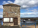
70 High Street 55°56′34″N 3°02′54″W / 55.94286°N 3.048432°W / 55.94286; -3.048432 (70 High Street ) Category C(S) 38324 128 & 130 High Street The Royal Esk 55°56′32″N 3°03′02″W / 55.942348°N 3.050548°W / 55.942348; -3.050548 (128 & 130 High Street The Royal Esk ) Category B 38328 136 High Street 55°56′33″N 3°03′03″W / 55.942363°N 3.050916°W / 55.942363; -3.050916 (136 High Street ) Category C(S) 38329 Inveresk Village Road St Michaels House, Gatepiers, Lodge And Stables 55°56′12″N 3°03′17″W / 55.936545°N 3.054601°W / 55.936545; -3.054601 (Inveresk Village Road St Michaels House, Gatepiers, Lodge And Stables ) Category B 38331 13, 15 And 17 Kilwinning Place 55°56′33″N 3°02′59″W / 55.942399°N 3.049861°W / 55.942399; -3.049861 (13, 15 And 17 Kilwinning Place ) Category C(S) 38333 6A Links Street, Congregational Church 55°56′40″N 3°03′25″W / 55.944549°N 3.05682°W / 55.944549; -3.05682 (6A Links Street, Congregational Church ) Category C(S) 38345 2-6 Mountjoy Terrace (Consecutive Numbers) 55°56′50″N 3°03′14″W / 55.947136°N 3.053832°W / 55.947136; -3.053832 (2-6 Mountjoy Terrace (Consecutive Numbers) ) Category C(S) 38357 Royal Bank Of Scotland, Bridge Street 55°56′35″N 3°03′24″W / 55.94297°N 3.056585°W / 55.94297; -3.056585 (Royal Bank Of Scotland, Bridge Street ) Category B 38259 23 Dalrymple Loan, Belleville 55°56′28″N 3°03′12″W / 55.941147°N 3.053317°W / 55.941147; -3.053317 (23 Dalrymple Loan, Belleville ) Category C(S) 38267 5 And 6 Eskside West 55°56′41″N 3°03′06″W / 55.944655°N 3.051779°W / 55.944655; -3.051779 (5 And 6 Eskside West ) Category C(S) 38275 12 Eskside West 55°56′36″N 3°03′15″W / 55.943251°N 3.054143°W / 55.943251; -3.054143 (12 Eskside West ) Category C(S) 38277 16 And 17 Eskside West 55°56′35″N 3°03′17″W / 55.943032°N 3.054617°W / 55.943032; -3.054617 (16 And 17 Eskside West ) Category C(S) 38280 101 And 103 North High Street Melville House 55°56′39″N 3°03′29″W / 55.944233°N 3.05814°W / 55.944233; -3.05814 (101 And 103 North High Street Melville House ) Category C(S) 38368 150 And 152 North High Street 55°56′37″N 3°03′42″W / 55.943718°N 3.061553°W / 55.943718; -3.061553 (150 And 152 North High Street ) Category C(S) 38375 2 Shorthope Street 55°56′34″N 3°03′05″W / 55.942863°N 3.051282°W / 55.942863; -3.051282 (2 Shorthope Street ) Category C(S) 38384 Stoneyhill House 55°56′22″N 3°04′01″W / 55.939467°N 3.066815°W / 55.939467; -3.066815 (Stoneyhill House ) Category B 38389 Fisherrow Harbour 55°56′44″N 3°04′03″W / 55.94568°N 3.067403°W / 55.94568; -3.067403 (Fisherrow Harbour ) Category B 38287 Upload another image
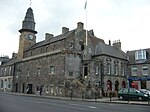
61, 61A High Street 55°56′36″N 3°02′55″W / 55.943281°N 3.048572°W / 55.943281; -3.048572 (61, 61A High Street ) Category C(S) 38306 86, 88 And 90 High Street Corner Of Kilwinning Street 55°56′34″N 3°02′56″W / 55.942739°N 3.048957°W / 55.942739; -3.048957 (86, 88 And 90 High Street Corner Of Kilwinning Street ) Category C(S) 38327 Linkfield Road Loretto School Doocot 55°56′41″N 3°02′47″W / 55.944728°N 3.046465°W / 55.944728; -3.046465 (Linkfield Road Loretto School Doocot ) Category B 38337 Linkfield Road Loretto School Colin Thomson Hall 55°56′43″N 3°02′48″W / 55.945166°N 3.046685°W / 55.945166; -3.046685 (Linkfield Road Loretto School Colin Thomson Hall ) Category B 38338 9 And 11 Linkfield Road 55°56′44″N 3°02′30″W / 55.945623°N 3.041574°W / 55.945623; -3.041574 (9 And 11 Linkfield Road ) Category C(S) 38339 1 Millhill Linkfield Cottage 55°56′45″N 3°02′35″W / 55.945753°N 3.043114°W / 55.945753; -3.043114 (1 Millhill Linkfield Cottage ) Category B 38347 96 And 98 Newbigging 55°56′23″N 3°02′54″W / 55.939618°N 3.048233°W / 55.939618; -3.048233 (96 And 98 Newbigging ) Category C(S) 38361 10 Balcarres Road Formerly Edinburgh Burgess Golfing Society 55°56′51″N 3°02′49″W / 55.947528°N 3.046829°W / 55.947528; -3.046829 (10 Balcarres Road Formerly Edinburgh Burgess Golfing Society ) Category B 38249 25 Dalrymple Loan, Glengyle House With Boundary Walls 55°56′27″N 3°03′11″W / 55.940916°N 3.052959°W / 55.940916; -3.052959 (25 Dalrymple Loan, Glengyle House With Boundary Walls ) Category C(S) 38268 31 And 33 Dalrymple Loan 55°56′27″N 3°03′10″W / 55.940747°N 3.052826°W / 55.940747; -3.052826 (31 And 33 Dalrymple Loan ) Category C(S) 38270 30 Eskside West 55°56′32″N 3°03′23″W / 55.942145°N 3.056354°W / 55.942145; -3.056354 (30 Eskside West ) Category C(S) 38283 253 North High Street Spring Bank 55°56′39″N 3°03′53″W / 55.944195°N 3.064624°W / 55.944195; -3.064624 (253 North High Street Spring Bank ) Category B 38370 Stoneyhill Former Steading David Lowe & Sons Ltd 55°56′21″N 3°03′56″W / 55.939199°N 3.065655°W / 55.939199; -3.065655 (Stoneyhill Former Steading David Lowe & Sons Ltd ) Category B 38388 49 High Street, Musselburgh Arms Hotel 55°56′36″N 3°02′53″W / 55.943375°N 3.048094°W / 55.943375; -3.048094 (49 High Street, Musselburgh Arms Hotel ) Category B 38303 High Street, Pinkie House Lodge And Gatepiers 55°56′37″N 3°02′42″W / 55.943699°N 3.0449°W / 55.943699; -3.0449 (High Street, Pinkie House Lodge And Gatepiers ) Category B 38315 High Street Pinkie House Stables 55°56′37″N 3°02′40″W / 55.943496°N 3.044447°W / 55.943496; -3.044447 (High Street Pinkie House Stables ) Category B 38316 12, 14 And 16 High Street 55°56′35″N 3°02′47″W / 55.943166°N 3.046279°W / 55.943166; -3.046279 (12, 14 And 16 High Street ) Category B 38321 76-84 High Street (Even Numbers) 55°56′34″N 3°02′55″W / 55.942804°N 3.048671°W / 55.942804; -3.048671 (76-84 High Street (Even Numbers) ) Category C(S) 38326 High Street High Church (Church Of Scotland) 55°56′31″N 3°03′15″W / 55.941806°N 3.054055°W / 55.941806; -3.054055 (High Street High Church (Church Of Scotland) ) Category B 38330 113, 115 And 117 Millhill 55°56′38″N 3°03′03″W / 55.943756°N 3.050826°W / 55.943756; -3.050826 (113, 115 And 117 Millhill ) Category B 38353 Newfield Loretto School Sports Pavilion 55°56′47″N 3°03′01″W / 55.946438°N 3.050306°W / 55.946438; -3.050306 (Newfield Loretto School Sports Pavilion ) Category B 38364 97 New Street Forth Yacht Club 55°56′42″N 3°03′51″W / 55.945124°N 3.064185°W / 55.945124; -3.064185 (97 New Street Forth Yacht Club ) Category C(S) 38365 18 And 20 Bridge Street 55°56′36″N 3°03′27″W / 55.943366°N 3.057572°W / 55.943366; -3.057572 (18 And 20 Bridge Street ) Category B 38261 39 And 41 Dalrymple Loan 55°56′26″N 3°03′10″W / 55.940559°N 3.052773°W / 55.940559; -3.052773 (39 And 41 Dalrymple Loan ) Category C(S) 38272 1 And 2 Eskside West 55°56′43″N 3°03′04″W / 55.945154°N 3.051216°W / 55.945154; -3.051216 (1 And 2 Eskside West ) Category C(S) 38273 3 And 4 Eskside West 55°56′42″N 3°03′05″W / 55.944937°N 3.051451°W / 55.944937; -3.051451 (3 And 4 Eskside West ) Category C(S) 38274 10 North High Street M & F Co-Operative Society, Former Butchery Department 55°56′38″N 3°03′18″W / 55.94391°N 3.054897°W / 55.94391; -3.054897 (10 North High Street M & F Co-Operative Society, Former Butchery Department ) Category B 38371 47 High Street 55°56′37″N 3°02′53″W / 55.943493°N 3.047969°W / 55.943493; -3.047969 (47 High Street ) Category B 38302 55 And 57 High Street 55°56′36″N 3°02′54″W / 55.943345°N 3.048413°W / 55.943345; -3.048413 (55 And 57 High Street ) Category B 38305 High Street Town House 55°56′35″N 3°02′56″W / 55.94318°N 3.048793°W / 55.94318; -3.048793 (High Street Town House ) Category A 38308 High Street Pinkie House Doocot 55°56′40″N 3°02′27″W / 55.944442°N 3.04095°W / 55.944442; -3.04095 (High Street Pinkie House Doocot ) Category B 38318 72 And 74 High Street The Inn Place 55°56′34″N 3°02′54″W / 55.942752°N 3.048461°W / 55.942752; -3.048461 (72 And 74 High Street The Inn Place ) Category C(S) 38325 15 Linkfield Road 55°56′43″N 3°02′28″W / 55.945267°N 3.041132°W / 55.945267; -3.041132 (15 Linkfield Road ) Category B 38341 Newbigging Our Lady Of Loretto And St Michael R C Church 55°56′30″N 3°02′54″W / 55.941656°N 3.0484°W / 55.941656; -3.0484 (Newbigging Our Lady Of Loretto And St Michael R C Church ) Category B 38358 New Bridge Between Bridge Street And High Street 55°56′32″N 3°03′17″W / 55.942304°N 3.054661°W / 55.942304; -3.054661 (New Bridge Between Bridge Street And High Street ) Category B 38363 8 Bridge Street 55°56′34″N 3°03′22″W / 55.94267°N 3.055984°W / 55.94267; -3.055984 (8 Bridge Street ) Category B 38258 29 Dalrymple Loan, Primrose House 55°56′27″N 3°03′10″W / 55.940809°N 3.052908°W / 55.940809; -3.052908 (29 Dalrymple Loan, Primrose House ) Category B 38269 13 Eskside West 55°56′36″N 3°03′15″W / 55.943197°N 3.054253°W / 55.943197; -3.054253 (13 Eskside West ) Category C(S) 38278 102, 104 And 106 North High Street 55°56′37″N 3°03′35″W / 55.943733°N 3.059776°W / 55.943733; -3.059776 (102, 104 And 106 North High Street ) Category B 38373 180 North High Street Jane Cottage 55°56′38″N 3°03′50″W / 55.943779°N 3.063908°W / 55.943779; -3.063908 (180 North High Street Jane Cottage ) Category C(S) 38377 Station Road Esk Mills 55°56′19″N 3°03′35″W / 55.938684°N 3.05975°W / 55.938684; -3.05975 (Station Road Esk Mills ) Category B 38386 7 High Street 55°56′37″N 3°02′46″W / 55.943714°N 3.04623°W / 55.943714; -3.04623 (7 High Street ) Category B 38293 15 High Street (Formerly Parsonage House) Including Gatepiers And Walls 55°56′39″N 3°02′50″W / 55.94403°N 3.047183°W / 55.94403; -3.047183 (15 High Street (Formerly Parsonage House) Including Gatepiers And Walls ) Category B 38296 51 And 53 High Street 55°56′36″N 3°02′54″W / 55.943364°N 3.048318°W / 55.943364; -3.048318 (51 And 53 High Street ) Category C(S) 38304 High Street Tolbooth 55°56′35″N 3°02′56″W / 55.94318°N 3.048793°W / 55.94318; -3.048793 (High Street Tolbooth ) Category A 38309 Upload another image
High Street, St Peter's Church (Episcopal) 55°56′36″N 3°02′43″W / 55.943461°N 3.045342°W / 55.943461; -3.045342 (High Street, St Peter's Church (Episcopal) ) Category B 38319 18 And 20 High Street 55°56′35″N 3°02′47″W / 55.943137°N 3.046518°W / 55.943137; -3.046518 (18 And 20 High Street ) Category B 38322 Linkfield Road Loretto School Gate-Lodge And Gatepiers 55°56′43″N 3°02′35″W / 55.94536°N 3.042928°W / 55.94536; -3.042928 (Linkfield Road Loretto School Gate-Lodge And Gatepiers ) Category B 38335 69 Millhill 55°56′40″N 3°02′58″W / 55.944335°N 3.049321°W / 55.944335; -3.049321 (69 Millhill ) Category C(S) 38350 1 Mountjoy Terrace 55°56′49″N 3°03′14″W / 55.94692°N 3.05381°W / 55.94692; -3.05381 (1 Mountjoy Terrace ) Category C(S) 38356 107 Newbigging 55°56′22″N 3°02′53″W / 55.939466°N 3.048132°W / 55.939466; -3.048132 (107 Newbigging ) Category C(S) 38359 Newbigging Lewisvale Public Park, Bandstand 55°56′20″N 3°02′44″W / 55.93894°N 3.045493°W / 55.93894; -3.045493 (Newbigging Lewisvale Public Park, Bandstand ) Category B 38362 11 And 12 Balcarres Road 55°56′51″N 3°02′49″W / 55.947609°N 3.046863°W / 55.947609; -3.046863 (11 And 12 Balcarres Road ) Category C(S) 38250 47 Bridge Street 55°56′36″N 3°03′24″W / 55.943419°N 3.056661°W / 55.943419; -3.056661 (47 Bridge Street ) Category B 38255 28 Eskside West 55°56′33″N 3°03′22″W / 55.942372°N 3.056104°W / 55.942372; -3.056104 (28 Eskside West ) Category C(S) 38281