Name Location Date Listed Grid Ref. [note 1] Geo-coordinates Notes LB Number [note 2] Image Sorn Castle, Turbine House 55°30′48″N 4°18′07″W / 55.513416°N 4.301963°W / 55.513416; -4.301963 (Sorn Castle, Turbine House ) Category C(S) 44574 2-10 (Even Nos) Ballochmyle Street, Catrine 55°30′19″N 4°20′06″W / 55.505187°N 4.334977°W / 55.505187; -4.334977 (2-10 (Even Nos) Ballochmyle Street, Catrine ) Category C(S) 43501 1-13 (Odd Nos) Ford Street, Catrine 55°30′15″N 4°19′49″W / 55.504091°N 4.330209°W / 55.504091; -4.330209 (1-13 (Odd Nos) Ford Street, Catrine ) Category C(S) 43505 16-26 (Even Nos) Mill Square, Catrine 55°30′15″N 4°19′57″W / 55.504121°N 4.332396°W / 55.504121; -4.332396 (16-26 (Even Nos) Mill Square, Catrine ) Category C(S) 43508 28-32 (Even Nos) Mill Square, Catrine 55°30′14″N 4°19′54″W / 55.503981°N 4.33177°W / 55.503981; -4.33177 (28-32 (Even Nos) Mill Square, Catrine ) Category C(S) 43509 10-14 (Even Nos) St Germain Street, Catrine 55°30′15″N 4°19′51″W / 55.504216°N 4.330754°W / 55.504216; -4.330754 (10-14 (Even Nos) St Germain Street, Catrine ) Category C(S) 43516 Catrine 2 Institute Avenue Library And Community Centre 55°30′10″N 4°19′55″W / 55.502907°N 4.33196°W / 55.502907; -4.33196 (Catrine 2 Institute Avenue Library And Community Centre ) Category C(S) 14268 Auchmannoch 55°32′57″N 4°18′44″W / 55.549176°N 4.312124°W / 55.549176; -4.312124 (Auchmannoch ) Category B 14269 Daldorch 55°30′26″N 4°19′02″W / 55.507241°N 4.317218°W / 55.507241; -4.317218 (Daldorch ) Category B 19680 Dalgain Mill 55°30′47″N 4°17′54″W / 55.513025°N 4.298377°W / 55.513025; -4.298377 (Dalgain Mill ) Category C(S) 14258 Sorn Castle 55°30′52″N 4°18′04″W / 55.514323°N 4.301018°W / 55.514323; -4.301018 (Sorn Castle ) Category A 14273 Catrine, St Cuthbert's Street, Footbridge Over The River Ayr 55°30′22″N 4°19′10″W / 55.506147°N 4.31945°W / 55.506147; -4.31945 (Catrine, St Cuthbert's Street, Footbridge Over The River Ayr ) Category C(S) 50121 Ballochmyle Street, Catrine, Ayr Bank House With Railings And Boundary Wall 55°30′18″N 4°20′08″W / 55.504941°N 4.335596°W / 55.504941; -4.335596 (Ballochmyle Street, Catrine, Ayr Bank House With Railings And Boundary Wall ) Category B 43499 10-14 (Even Nos) Mill Square, Catrine 55°30′15″N 4°19′58″W / 55.504142°N 4.332714°W / 55.504142; -4.332714 (10-14 (Even Nos) Mill Square, Catrine ) Category C(S) 43507 34-38 (Even Nos) Mill Square, Catrine 55°30′14″N 4°19′54″W / 55.503958°N 4.331547°W / 55.503958; -4.331547 (34-38 (Even Nos) Mill Square, Catrine ) Category C(S) 43510 St Germain Street And Mill Square, Catrine, The Royal 55°30′15″N 4°19′52″W / 55.504281°N 4.331091°W / 55.504281; -4.331091 (St Germain Street And Mill Square, Catrine, The Royal ) Category C(S) 43513 22-34 (Even Nos)St Germain Street, Including The Brewery Bar, Catrine 55°30′14″N 4°19′47″W / 55.504°N 4.329807°W / 55.504; -4.329807 (22-34 (Even Nos)St Germain Street, Including The Brewery Bar, Catrine ) Category C(S) 43518 1 Ballochmyle Street, Catrine 55°30′18″N 4°20′07″W / 55.504903°N 4.335245°W / 55.504903; -4.335245 (1 Ballochmyle Street, Catrine ) Category C(S) 43500 42-46 (Even Nos) Mill Square, Catrine 55°30′14″N 4°19′53″W / 55.503971°N 4.33131°W / 55.503971; -4.33131 (42-46 (Even Nos) Mill Square, Catrine ) Category C(S) 43511 Dalgain 55°30′35″N 4°16′55″W / 55.509827°N 4.281924°W / 55.509827; -4.281924 (Dalgain ) Category C(S) 14261 Glenlogan 55°30′27″N 4°16′09″W / 55.507385°N 4.269224°W / 55.507385; -4.269224 (Glenlogan ) Category B 14262 Catrine Parish Church 55°30′20″N 4°19′58″W / 55.50555°N 4.332876°W / 55.50555; -4.332876 (Catrine Parish Church ) Category A 14264 Upload another image
2 Bridge Street, Catrine 55°30′14″N 4°19′56″W / 55.50399°N 4.33223°W / 55.50399; -4.33223 (2 Bridge Street, Catrine ) Category C(S) 43502 Mill Square And 3-5 Bridge Street, Catrine, Volunteer Arms 55°30′14″N 4°19′55″W / 55.503934°N 4.331862°W / 55.503934; -4.331862 (Mill Square And 3-5 Bridge Street, Catrine, Volunteer Arms ) Category C(S) 43506 8 St Germain Street, Catrine 55°30′15″N 4°19′52″W / 55.504173°N 4.3311°W / 55.504173; -4.3311 (8 St Germain Street, Catrine ) Category C(S) 43515 Sorn, Entrance Lodge And Gateway 55°30′59″N 4°18′18″W / 55.516389°N 4.304909°W / 55.516389; -4.304909 (Sorn, Entrance Lodge And Gateway ) Category B 14256 Upload another image
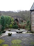
Sorn New Bridge 55°30′36″N 4°17′17″W / 55.509964°N 4.288077°W / 55.509964; -4.288077 (Sorn New Bridge ) Category B 14259 Upload another image
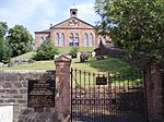
Parish Church And Graveyard, Sorn 55°30′47″N 4°17′51″W / 55.51296°N 4.297502°W / 55.51296; -4.297502 (Parish Church And Graveyard, Sorn ) Category B 14271 Stables, Sorn Castle 55°30′55″N 4°18′18″W / 55.515263°N 4.305049°W / 55.515263; -4.305049 (Stables, Sorn Castle ) Category A 14274 Sorn Kirkside Place Formerly The Manse 55°30′46″N 4°17′47″W / 55.512863°N 4.296482°W / 55.512863; -4.296482 (Sorn Kirkside Place Formerly The Manse ) Category C(S) 14275 4 And 8 Bridge Street, Catrine 55°30′15″N 4°19′51″W / 55.504248°N 4.330915°W / 55.504248; -4.330915 (4 And 8 Bridge Street, Catrine ) Category C(S) 43503 20-24 Mill Street, Catrine, The Old Mill Inn 55°30′18″N 4°20′02″W / 55.505008°N 4.333984°W / 55.505008; -4.333984 (20-24 Mill Street, Catrine, The Old Mill Inn ) Category C(S) 43512 16-20 (Even Nos) St Germain Street, Catrine 55°30′15″N 4°19′50″W / 55.504166°N 4.330546°W / 55.504166; -4.330546 (16-20 (Even Nos) St Germain Street, Catrine ) Category C(S) 43517 Burnside Cottage 55°31′08″N 4°19′31″W / 55.518972°N 4.325164°W / 55.518972; -4.325164 (Burnside Cottage ) Category B 14266 Gilmilnscroft 55°30′07″N 4°16′55″W / 55.501881°N 4.281987°W / 55.501881; -4.281987 (Gilmilnscroft ) Category B 14270 Catrine Village, St. Germain Street Nether Catrine House 55°30′13″N 4°19′41″W / 55.503495°N 4.327988°W / 55.503495; -4.327988 (Catrine Village, St. Germain Street Nether Catrine House ) Category B 14276 40 Mill Square 55°30′14″N 4°19′53″W / 55.503951°N 4.33142°W / 55.503951; -4.33142 (40 Mill Square ) Category C(S) 51098 11-12 Bridge Street, Catrine 55°30′13″N 4°19′55″W / 55.503689°N 4.331974°W / 55.503689; -4.331974 (11-12 Bridge Street, Catrine ) Category C(S) 43504 Sorn Castle, East Gatehouse, Cleuch Cottage 55°30′53″N 4°17′57″W / 55.514769°N 4.299302°W / 55.514769; -4.299302 (Sorn Castle, East Gatehouse, Cleuch Cottage ) Category B 19666 No. 1 Ladeside Cottage 55°30′47″N 4°17′54″W / 55.513135°N 4.298256°W / 55.513135; -4.298256 (No. 1 Ladeside Cottage ) Category C(S) 14257 Bridge Over River Ayr, Opposite Sorn Parish Church 55°30′46″N 4°17′54″W / 55.512738°N 4.29836°W / 55.512738; -4.29836 (Bridge Over River Ayr, Opposite Sorn Parish Church ) Category A 14272 Upload another image
St Germain Street, Catrine, The Royal Bank Of Scotland With Boundary Walls 55°30′16″N 4°19′52″W / 55.504462°N 4.331007°W / 55.504462; -4.331007 (St Germain Street, Catrine, The Royal Bank Of Scotland With Boundary Walls ) Category C(S) 43514 Sawmill Cottage And Gatepiers 55°30′57″N 4°18′34″W / 55.515848°N 4.309329°W / 55.515848; -4.309329 (Sawmill Cottage And Gatepiers ) Category C(S) 19681 Nethershield Farmhouse And Steading 55°30′53″N 4°14′34″W / 55.514757°N 4.242768°W / 55.514757; -4.242768 (Nethershield Farmhouse And Steading ) Category B 19258 School, Sorn 55°30′38″N 4°17′31″W / 55.510559°N 4.291818°W / 55.510559; -4.291818 (School, Sorn ) Category B 14260 Stables, Daldorch 55°30′23″N 4°19′07″W / 55.506263°N 4.318539°W / 55.506263; -4.318539 (Stables, Daldorch ) Category B 14263