Name Location Date Listed Grid Ref. [note 1] Geo-coordinates Notes LB Number [note 2] Image Lainshaw House 55°40′29″N 4°31′47″W / 55.674803°N 4.529721°W / 55.674803; -4.529721 (Lainshaw House ) Category B 41076 Upload another image See more images
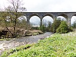
41 Graham Terrace, Ashbank Including Gatepiers 55°41′03″N 4°31′02″W / 55.684292°N 4.517177°W / 55.684292; -4.517177 (41 Graham Terrace, Ashbank Including Gatepiers ) Category C(S) 41082 Robertland Bridge Over Annick Water 55°41′35″N 4°29′04″W / 55.693046°N 4.484561°W / 55.693046; -4.484561 (Robertland Bridge Over Annick Water ) Category C(S) 19884 21 Draffen Mount, Draffen House 55°40′37″N 4°30′22″W / 55.676836°N 4.505977°W / 55.676836; -4.505977 (21 Draffen Mount, Draffen House ) Category C(S) 45920 22 And 24 Lainshaw Street, Including The Royal Bank Of Scotland 55°40′47″N 4°30′57″W / 55.679789°N 4.515837°W / 55.679789; -4.515837 (22 And 24 Lainshaw Street, Including The Royal Bank Of Scotland ) Category C(S) 51375 11-15 (Odd Nos) Main Street 55°40′49″N 4°30′54″W / 55.680321°N 4.514885°W / 55.680321; -4.514885 (11-15 (Odd Nos) Main Street ) Category C(S) 51377 Annick Water Viaduct 55°40′38″N 4°31′10″W / 55.677359°N 4.519515°W / 55.677359; -4.519515 (Annick Water Viaduct ) Category B 41074 Upload another image See more images
Kilwinning Road, Dovecot At Deersland Farm 55°40′17″N 4°34′18″W / 55.67144°N 4.571715°W / 55.67144; -4.571715 (Kilwinning Road, Dovecot At Deersland Farm ) Category C(S) 18491 Kilwinning Road, Kennox Cottage 55°40′12″N 4°34′12″W / 55.669929°N 4.570025°W / 55.669929; -4.570025 (Kilwinning Road, Kennox Cottage ) Category C(S) 18493 Old Glasgow Road, Fulshaw Farm 55°41′44″N 4°29′20″W / 55.695562°N 4.489001°W / 55.695562; -4.489001 (Old Glasgow Road, Fulshaw Farm ) Category C(S) 18495 2 Robertland, The Gatehouse, Including Gate Piers 55°41′39″N 4°29′28″W / 55.694145°N 4.491076°W / 55.694145; -4.491076 (2 Robertland, The Gatehouse, Including Gate Piers ) Category C(S) 18499 Old Kilmarnock Road, High Peacockbank House 55°40′13″N 4°30′43″W / 55.670311°N 4.51208°W / 55.670311; -4.51208 (Old Kilmarnock Road, High Peacockbank House ) Category C(S) 18500 Auchentiber House, Including Outbuildings And Boundary Walls And Gatepiers 55°42′35″N 4°29′01″W / 55.709782°N 4.483665°W / 55.709782; -4.483665 (Auchentiber House, Including Outbuildings And Boundary Walls And Gatepiers ) Category C(S) 51553 15 Vennel Street, Woodlands, Including Gate Piers And Boundary Walls 55°40′46″N 4°30′48″W / 55.6794°N 4.513315°W / 55.6794; -4.513315 (15 Vennel Street, Woodlands, Including Gate Piers And Boundary Walls ) Category C(S) 41069 14 And 16 Kirkford 55°40′33″N 4°30′41″W / 55.675883°N 4.511276°W / 55.675883; -4.511276 (14 And 16 Kirkford ) Category C(S) 41072 2 And 7 David Dale Avenue, (Former East Gate To Lainshaw House) 55°40′35″N 4°31′38″W / 55.676339°N 4.527148°W / 55.676339; -4.527148 (2 And 7 David Dale Avenue, (Former East Gate To Lainshaw House) ) Category C(S) 41077 Lainshaw Stables 55°40′33″N 4°31′49″W / 55.675697°N 4.530383°W / 55.675697; -4.530383 (Lainshaw Stables ) Category B 41078 Girgenti Cottage 55°39′25″N 4°36′00″W / 55.657079°N 4.600122°W / 55.657079; -4.600122 (Girgenti Cottage ) Category C(S) 18488 Old Glasgow Road, High Williamshaw, Including Outbuilding 55°42′12″N 4°29′02″W / 55.703215°N 4.483965°W / 55.703215; -4.483965 (Old Glasgow Road, High Williamshaw, Including Outbuilding ) Category A 18496 Upload another image
Cutstraw Cottage 55°40′45″N 4°29′41″W / 55.679035°N 4.49468°W / 55.679035; -4.49468 (Cutstraw Cottage ) Category C(S) 18501 8 Vennel Street 55°40′48″N 4°30′54″W / 55.679966°N 4.515085°W / 55.679966; -4.515085 (8 Vennel Street ) Category C(S) 49115 Dalry Road, Cemetery House And Offices, Including Gates And Gatepiers 55°40′55″N 4°31′31″W / 55.68198°N 4.525142°W / 55.68198; -4.525142 (Dalry Road, Cemetery House And Offices, Including Gates And Gatepiers ) Category C(S) 51370 3-7 (Odd Nos) Lainshaw Street 55°40′49″N 4°30′56″W / 55.680197°N 4.515673°W / 55.680197; -4.515673 (3-7 (Odd Nos) Lainshaw Street ) Category C(S) 51371 1 Loudoun Street 55°40′35″N 4°30′39″W / 55.676487°N 4.510726°W / 55.676487; -4.510726 (1 Loudoun Street ) Category C(S) 51376 High Street, John Knox Parish Church, (Church Of Scotland) 55°40′51″N 4°30′50″W / 55.680963°N 4.513813°W / 55.680963; -4.513813 (High Street, John Knox Parish Church, (Church Of Scotland) ) Category B 41065 Upload another image
Girgenti Farm, Including Tower And Outbuildings 55°39′29″N 4°36′02″W / 55.658098°N 4.600428°W / 55.658098; -4.600428 (Girgenti Farm, Including Tower And Outbuildings ) Category C(S) 18486 Upload another image See more images
Robertland, Including Outbuildings, Cottage And Walled Garden 55°41′30″N 4°28′54″W / 55.691756°N 4.481694°W / 55.691756; -4.481694 (Robertland, Including Outbuildings, Cottage And Walled Garden ) Category B 18498 Merryhill Farm And Ancillary Buildings 55°42′22″N 4°29′39″W / 55.706151°N 4.494275°W / 55.706151; -4.494275 (Merryhill Farm And Ancillary Buildings ) Category C(S) 18505 8 Avenue Square, Former Burgh Offices 55°40′53″N 4°30′52″W / 55.681316°N 4.514552°W / 55.681316; -4.514552 (8 Avenue Square, Former Burgh Offices ) Category C(S) 41067 High Street And Avenue Square, Including 2B High Street, Bank Of Scotland 55°40′51″N 4°30′52″W / 55.680951°N 4.514385°W / 55.680951; -4.514385 (High Street And Avenue Square, Including 2B High Street, Bank Of Scotland ) Category C(S) 41068 30 Vennel Street And 32 Vennel Street, Braehead House 55°40′45″N 4°30′51″W / 55.679048°N 4.514295°W / 55.679048; -4.514295 (30 Vennel Street And 32 Vennel Street, Braehead House ) Category B 41070 Auchenharvie Castle 55°39′53″N 4°36′16″W / 55.66462°N 4.604375°W / 55.66462; -4.604375 (Auchenharvie Castle ) Category B 18485 2-6 (Even Nos) Lainshaw Street & 2-6 (Even Nos) Vennel Street 55°40′48″N 4°30′55″W / 55.680078°N 4.515347°W / 55.680078; -4.515347 (2-6 (Even Nos) Lainshaw Street & 2-6 (Even Nos) Vennel Street ) Category C(S) 49114 16-20 (Even Nos) Lainshaw Street, Including Outbuildings 55°40′48″N 4°30′56″W / 55.679964°N 4.515658°W / 55.679964; -4.515658 (16-20 (Even Nos) Lainshaw Street, Including Outbuildings ) Category C(S) 51552 Avenue Square, Institute Hall 55°40′51″N 4°30′53″W / 55.680942°N 4.51483°W / 55.680942; -4.51483 (Avenue Square, Institute Hall ) Category C(S) 41066 16, 18 And 20 Standalane, Standalane House 55°38′45″N 4°31′45″W / 55.645746°N 4.52915°W / 55.645746; -4.52915 (16, 18 And 20 Standalane, Standalane House ) Category C(S) 41075 Kilwinning Road, Lainshaw Mains Farm 55°40′41″N 4°31′55″W / 55.678137°N 4.531925°W / 55.678137; -4.531925 (Kilwinning Road, Lainshaw Mains Farm ) Category B 41079 Upload another image
Corsehill Castle 55°41′12″N 4°31′09″W / 55.686756°N 4.519292°W / 55.686756; -4.519292 (Corsehill Castle ) Category B 41080 9-13 (Odd Nos) Lainshaw Street 55°40′49″N 4°30′57″W / 55.680204°N 4.515753°W / 55.680204; -4.515753 (9-13 (Odd Nos) Lainshaw Street ) Category C(S) 51372 14 Lainshaw Street 55°40′48″N 4°30′56″W / 55.679984°N 4.515516°W / 55.679984; -4.515516 (14 Lainshaw Street ) Category C(S) 51374 12 Kirkford 55°40′36″N 4°30′41″W / 55.676752°N 4.51138°W / 55.676752; -4.51138 (12 Kirkford ) Category C(S) 41071 13 Vennel Street, Kersland 55°40′47″N 4°30′50″W / 55.679823°N 4.513756°W / 55.679823; -4.513756 (13 Vennel Street, Kersland ) Category B 41081 Chapeltoun House 55°39′54″N 4°33′11″W / 55.66501°N 4.552942°W / 55.66501; -4.552942 (Chapeltoun House ) Category C(S) 51379 Upload another image See more images
13 Loudoun Street, Cragston House 55°40′32″N 4°30′26″W / 55.675606°N 4.507234°W / 55.675606; -4.507234 (13 Loudoun Street, Cragston House ) Category C(S) 51389 St Columba's Parish Church And Kirkyard, Including Boundary Walls, (Church Of Scotland) 55°40′44″N 4°30′58″W / 55.67883°N 4.516126°W / 55.67883; -4.516126 (St Columba's Parish Church And Kirkyard, Including Boundary Walls, (Church Of Scotland) ) Category B 41063 Upload another image
Little Cutstraw House 55°40′27″N 4°30′02″W / 55.674234°N 4.500482°W / 55.674234; -4.500482 (Little Cutstraw House ) Category C(S) 19885 Fairliecrevoch Farm, Including The Farmhouse, The Stone Barn, The Auld Dairy, The Old Byre And The Stable 55°38′52″N 4°35′34″W / 55.647677°N 4.592902°W / 55.647677; -4.592902 (Fairliecrevoch Farm, Including The Farmhouse, The Stone Barn, The Auld Dairy, The Old Byre And The Stable ) Category C(S) 18489 Kennox House, Including Gatepiers And Gates And Boundary Walls 55°40′16″N 4°34′12″W / 55.671062°N 4.570004°W / 55.671062; -4.570004 (Kennox House, Including Gatepiers And Gates And Boundary Walls ) Category A 18490 15-19 (Odd Nos) Lainshaw Street 55°40′48″N 4°30′57″W / 55.680129°N 4.515923°W / 55.680129; -4.515923 (15-19 (Odd Nos) Lainshaw Street ) Category C(S) 51373