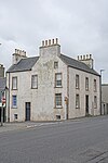
Name Location Date Listed Grid Ref. [note 1] Geo-coordinates Notes LB Number [note 2] Image 4 And 6, Campbell Street 58°35′42″N 3°31′20″W / 58.594991°N 3.522149°W / 58.594991; -3.522149 (4 And 6, Campbell Street ) Category C(S) 41976 Upload Photo 14, 16, 18 Campbell Street 58°35′41″N 3°31′22″W / 58.594626°N 3.522666°W / 58.594626; -3.522666 (14, 16, 18 Campbell Street ) Category C(S) 41979 Upload Photo Castle Street Former West Public Primary School 58°35′44″N 3°31′33″W / 58.59564°N 3.525739°W / 58.59564; -3.525739 (Castle Street Former West Public Primary School ) Category C(S) 41983 Upload Photo 24, Durness Street Allendale 58°35′47″N 3°31′21″W / 58.596334°N 3.522551°W / 58.596334; -3.522551 (24, Durness Street Allendale ) Category B 41986 Upload Photo High Street, Town Hall 58°35′44″N 3°31′05″W / 58.595667°N 3.518135°W / 58.595667; -3.518135 (High Street, Town Hall ) Category B 41988 Upload another image
1, Janet Street 58°35′34″N 3°31′15″W / 58.592806°N 3.520815°W / 58.592806; -3.520815 (1, Janet Street ) Category B 41989 Upload Photo 3, Janet Street House And Stables/Gighouse 58°35′34″N 3°31′18″W / 58.592644°N 3.5216°W / 58.592644; -3.5216 (3, Janet Street House And Stables/Gighouse ) Category B 41991 Upload Photo 6, Janet Street The Thurso Club 58°35′32″N 3°31′20″W / 58.592115°N 3.522282°W / 58.592115; -3.522282 (6, Janet Street The Thurso Club ) Category C(S) 41993 Upload Photo 43, 45 Olrig Street 58°35′47″N 3°31′28″W / 58.596348°N 3.524359°W / 58.596348; -3.524359 (43, 45 Olrig Street ) Category C(S) 42007 Upload Photo 2, Princes Street And Court Yard Wall 58°35′41″N 3°31′16″W / 58.594823°N 3.521144°W / 58.594823; -3.521144 (2, Princes Street And Court Yard Wall ) Category C(S) 42013 Upload Photo 12, Princes Street 58°35′40″N 3°31′17″W / 58.594577°N 3.521477°W / 58.594577; -3.521477 (12, Princes Street ) Category C(S) 42017 Upload Photo 16, 18, Shore Street 58°35′49″N 3°30′59″W / 58.597016°N 3.51649°W / 58.597016; -3.51649 (16, 18, Shore Street ) Category B 42025 Upload Photo 6, 8 Barrock Street Piers And Garden Walls 58°35′36″N 3°31′28″W / 58.593456°N 3.524336°W / 58.593456; -3.524336 (6, 8 Barrock Street Piers And Garden Walls ) Category B 41962 Upload Photo Aimster Farmhouse 58°32′54″N 3°31′02″W / 58.548333°N 3.517135°W / 58.548333; -3.517135 (Aimster Farmhouse ) Category B 14920 Upload Photo Sordale Farm 58°32′14″N 3°27′59″W / 58.537255°N 3.46629°W / 58.537255; -3.46629 (Sordale Farm ) Category B 14956 Upload Photo 20, Campbell Street 58°35′40″N 3°31′22″W / 58.59447°N 3.5229°W / 58.59447; -3.5229 (20, Campbell Street ) Category C(S) 41980 Upload Photo Davidson's Lane Miller Institution 58°35′29″N 3°31′30″W / 58.591509°N 3.524922°W / 58.591509; -3.524922 (Davidson's Lane Miller Institution ) Category B 41984 Upload Photo Granville Street, Pentland House And Garden Walls 58°35′47″N 3°31′39″W / 58.59648°N 3.527634°W / 58.59648; -3.527634 (Granville Street, Pentland House And Garden Walls ) Category B 41987 Upload Photo 8 Janet Street 58°35′29″N 3°31′23″W / 58.59146°N 3.522993°W / 58.59146; -3.522993 (8 Janet Street ) Category B 41995 Upload Photo 20, Miller's Lane 58°35′45″N 3°30′55″W / 58.595942°N 3.515411°W / 58.595942; -3.515411 (20, Miller's Lane ) Category B 42003 Upload Photo Princes Street, Greenacres, House And Stable With Gighouse. (Former Free Church And Subsequently Church Of Scotland Manse) 58°35′29″N 3°31′43″W / 58.591502°N 3.528535°W / 58.591502; -3.528535 (Princes Street, Greenacres, House And Stable With Gighouse. (Former Free Church And Subsequently Church Of Scotland Manse) ) Category C(S) 42012 Upload Photo 4, Princes Street 58°35′41″N 3°31′16″W / 58.594778°N 3.521176°W / 58.594778; -3.521176 (4, Princes Street ) Category C(S) 42014 Upload Photo 30, Princes Street 58°35′37″N 3°31′23″W / 58.593535°N 3.523015°W / 58.593535; -3.523015 (30, Princes Street ) Category B 42019 Upload another image
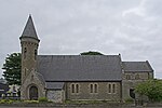
9, Rose Street ("Aldourie") And 11, Rose Street ("Bothangarrow") 58°35′41″N 3°31′28″W / 58.594695°N 3.524356°W / 58.594695; -3.524356 (9, Rose Street ("Aldourie") And 11, Rose Street ("Bothangarrow") ) Category C(S) 42023 Upload Photo 21, 23, 25, Rose Street (Right To Left) 58°35′39″N 3°31′31″W / 58.594156°N 3.525141°W / 58.594156; -3.525141 (21, 23, 25, Rose Street (Right To Left) ) Category C(S) 42024 Upload Photo Sinclair Street Thurso West Church (Church Of Scotland) Church Room And Gate Piers 58°35′32″N 3°31′27″W / 58.592299°N 3.524183°W / 58.592299; -3.524183 (Sinclair Street Thurso West Church (Church Of Scotland) Church Room And Gate Piers ) Category B 42027 Upload Photo Sir George's Street, Episcopal Church Of St Peter And The Holy Rood 58°35′36″N 3°31′14″W / 58.593268°N 3.520508°W / 58.593268; -3.520508 (Sir George's Street, Episcopal Church Of St Peter And The Holy Rood ) Category C(S) 42029 Upload another image
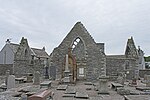
Sir John's Square Sir George Sinclair Memorial Fountain 58°35′38″N 3°31′22″W / 58.593789°N 3.522733°W / 58.593789; -3.522733 (Sir John's Square Sir George Sinclair Memorial Fountain ) Category C(S) 42030 Upload Photo Sir John's Square, Sir John Sinclair Memorial 58°35′37″N 3°31′21″W / 58.593668°N 3.522401°W / 58.593668; -3.522401 (Sir John's Square, Sir John Sinclair Memorial ) Category B 42032 Upload Photo 1, 3, 5, 7, 9 Traill Street 58°35′41″N 3°31′14″W / 58.594686°N 3.520621°W / 58.594686; -3.520621 (1, 3, 5, 7, 9 Traill Street ) Category C(S) 42036 Upload Photo 11, Traill Street 58°35′40″N 3°31′15″W / 58.594565°N 3.52096°W / 58.594565; -3.52096 (11, Traill Street ) Category B 42037 Upload Photo 13, Traill Street 58°35′40″N 3°31′16″W / 58.594519°N 3.521079°W / 58.594519; -3.521079 (13, Traill Street ) Category B 42038 Upload Photo 37 Traill Street 58°35′38″N 3°31′19″W / 58.59389°N 3.52186°W / 58.59389; -3.52186 (37 Traill Street ) Category C(S) 42042 Upload Photo 7 Wilson Lane 58°35′48″N 3°31′01″W / 58.596689°N 3.516837°W / 58.596689; -3.516837 (7 Wilson Lane ) Category B 42045 Upload Photo K6 Telephone Kiosk At Town Hall 58°35′44″N 3°31′06″W / 58.595619°N 3.518408°W / 58.595619; -3.518408 (K6 Telephone Kiosk At Town Hall ) Category B 42047 Upload Photo 10 Barrock Street 58°35′36″N 3°31′28″W / 58.593301°N 3.524519°W / 58.593301; -3.524519 (10 Barrock Street ) Category C(S) 41963 Upload Photo Harold's Tower Mausoleum 58°36′09″N 3°29′22″W / 58.602443°N 3.489498°W / 58.602443; -3.489498 (Harold's Tower Mausoleum ) Category B 14919 Upload Photo Scrabster House 58°36′27″N 3°33′09″W / 58.607499°N 3.552591°W / 58.607499; -3.552591 (Scrabster House ) Category C(S) 14954 Upload Photo Scrabster Ice House And Adjoining Cottage 58°36′46″N 3°32′51″W / 58.612644°N 3.547482°W / 58.612644; -3.547482 (Scrabster Ice House And Adjoining Cottage ) Category C(S) 14955 Upload Photo 15, Campbell Street 58°35′40″N 3°31′24″W / 58.594555°N 3.5233°W / 58.594555; -3.5233 (15, Campbell Street ) Category B 41972 Upload Photo 17, Campbell Street 58°35′40″N 3°31′24″W / 58.594482°N 3.5234°W / 58.594482; -3.5234 (17, Campbell Street ) Category B 41973 Upload Photo 10, 12 Campbell Street 58°35′41″N 3°31′21″W / 58.594808°N 3.522399°W / 58.594808; -3.522399 (10, 12 Campbell Street ) Category C(S) 41978 Upload Photo 2, Janet Street 58°35′34″N 3°31′16″W / 58.592642°N 3.521066°W / 58.592642; -3.521066 (2, Janet Street ) Category B 41990 Upload Photo 22, 24, Manson's Lane The Brewer's House (22) And Old Brewery (24) 58°35′37″N 3°31′10″W / 58.593694°N 3.519426°W / 58.593694; -3.519426 (22, 24, Manson's Lane The Brewer's House (22) And Old Brewery (24) ) Category B 41998 Upload Photo 6, 7, Market Street 58°35′47″N 3°31′07″W / 58.596373°N 3.518475°W / 58.596373; -3.518475 (6, 7, Market Street ) Category C(S) 42000 Upload Photo Millbank Road, Former Thurso Mill 58°35′20″N 3°31′21″W / 58.588824°N 3.522569°W / 58.588824; -3.522569 (Millbank Road, Former Thurso Mill ) Category B 42001 Upload Photo Shore Street, Kippering House With Kiln, Fish-House, Yard, Store And Shop 58°35′48″N 3°31′01″W / 58.596769°N 3.516857°W / 58.596769; -3.516857 (Shore Street, Kippering House With Kiln, Fish-House, Yard, Store And Shop ) Category B 42026 Upload Photo Thurso Railway Station 58°35′24″N 3°31′40″W / 58.590101°N 3.527769°W / 58.590101; -3.527769 (Thurso Railway Station ) Category B 42035 Upload Photo 25, 27, 29, 31, 33, 35, Traill Street 58°35′39″N 3°31′17″W / 58.594127°N 3.521526°W / 58.594127; -3.521526 (25, 27, 29, 31, 33, 35, Traill Street ) Category B 42041 Upload Photo 18, Barrock Street 58°35′35″N 3°31′30″W / 58.592963°N 3.525003°W / 58.592963; -3.525003 (18, Barrock Street ) Category C(S) 41965 Upload Photo 7, Campbell Street 58°35′41″N 3°31′22″W / 58.594848°N 3.522865°W / 58.594848; -3.522865 (7, Campbell Street ) Category B 41968 Upload Photo 9, Campbell Street 58°35′41″N 3°31′23″W / 58.594738°N 3.523033°W / 58.594738; -3.523033 (9, Campbell Street ) Category B 41969 Upload Photo Forss Water, Humpback Bridge 58°35′06″N 3°39′03″W / 58.584886°N 3.650946°W / 58.584886; -3.650946 (Forss Water, Humpback Bridge ) Category B 44721 Upload Photo 16, Olrig Street 58°35′43″N 3°31′19″W / 58.595155°N 3.521949°W / 58.595155; -3.521949 (16, Olrig Street ) Category C(S) 42008 Upload Photo 14, Princes Street 58°35′40″N 3°31′18″W / 58.594522°N 3.521561°W / 58.594522; -3.521561 (14, Princes Street ) Category C(S) 42018 Upload Photo 23, Riverside Place 58°35′38″N 3°31′08″W / 58.593772°N 3.518896°W / 58.593772; -3.518896 (23, Riverside Place ) Category C(S) 42021 Upload Photo 24, Sinclair Street 58°35′32″N 3°31′25″W / 58.592271°N 3.523493°W / 58.592271; -3.523493 (24, Sinclair Street ) Category C(S) 42028 Upload Photo Thurso Bridge Over River Thurso 58°35′33″N 3°31′10″W / 58.592515°N 3.519581°W / 58.592515; -3.519581 (Thurso Bridge Over River Thurso ) Category B 42033 Upload Photo 15 And 17 Traill Street, Clydesdale Bank 58°35′40″N 3°31′16″W / 58.594428°N 3.521144°W / 58.594428; -3.521144 (15 And 17 Traill Street, Clydesdale Bank ) Category B 42039 Upload Photo 2, 4 Barrock Street 58°35′38″N 3°31′26″W / 58.593858°N 3.523769°W / 58.593858; -3.523769 (2, 4 Barrock Street ) Category C(S) 41961 Upload Photo 11, Brabster Street 58°35′33″N 3°31′21″W / 58.592438°N 3.522365°W / 58.592438; -3.522365 (11, Brabster Street ) Category C(S) 41966 Upload Photo Aimster Farm Dwellings 58°32′54″N 3°31′03″W / 58.548238°N 3.517577°W / 58.548238; -3.517577 (Aimster Farm Dwellings ) Category C(S) 14921 Upload Photo Brims Castle 58°36′59″N 3°38′55″W / 58.616507°N 3.648684°W / 58.616507; -3.648684 (Brims Castle ) Category B 14922 Upload Photo Forss Mill And Miller's House (East) 58°35′44″N 3°39′32″W / 58.595572°N 3.658832°W / 58.595572; -3.658832 (Forss Mill And Miller's House (East) ) Category B 14925 Upload Photo 19, Campbell Street 58°35′40″N 3°31′25″W / 58.594427°N 3.523501°W / 58.594427; -3.523501 (19, Campbell Street ) Category B 41974 Upload Photo Castle Street, Congregational Church 58°35′43″N 3°31′34″W / 58.595195°N 3.526132°W / 58.595195; -3.526132 (Castle Street, Congregational Church ) Category C(S) 41982 Upload Photo 9 And 10, Janet Street 58°35′29″N 3°31′24″W / 58.591321°N 3.523366°W / 58.591321; -3.523366 (9 And 10, Janet Street ) Category B 41996 Upload Photo Olrig Street Bank Of Scotland 58°35′44″N 3°31′19″W / 58.595434°N 3.521927°W / 58.595434; -3.521927 (Olrig Street Bank Of Scotland ) Category B 42005 Upload Photo 6, Princes Street 58°35′41″N 3°31′16″W / 58.594687°N 3.521241°W / 58.594687; -3.521241 (6, Princes Street ) Category C(S) 42015 Upload Photo Wilson Lane, Old St Peter`S Church And Burial Ground 58°35′48″N 3°30′54″W / 58.596575°N 3.515042°W / 58.596575; -3.515042 (Wilson Lane, Old St Peter`S Church And Burial Ground ) Category A 42044 Upload another image
8, Campbell Street 58°35′42″N 3°31′20″W / 58.59489°N 3.522299°W / 58.59489; -3.522299 (8, Campbell Street ) Category C(S) 41977 Upload Photo 50, Duncan Street 58°35′36″N 3°31′37″W / 58.593318°N 3.526894°W / 58.593318; -3.526894 (50, Duncan Street ) Category C(S) 41985 Upload Photo 4, Janet Street 58°35′32″N 3°31′18″W / 58.59231°N 3.52174°W / 58.59231; -3.52174 (4, Janet Street ) Category B 41992 Upload Photo 7, Janet Street 58°35′30″N 3°31′22″W / 58.591643°N 3.522726°W / 58.591643; -3.522726 (7, Janet Street ) Category B 41994 Upload Photo Millbank, Foundry 58°35′21″N 3°31′20″W / 58.589207°N 3.522138°W / 58.589207; -3.522138 (Millbank, Foundry ) Category C(S) 42002 Upload Photo Olrig Street Former St Andrew's Church 58°35′45″N 3°31′20″W / 58.595907°N 3.522154°W / 58.595907; -3.522154 (Olrig Street Former St Andrew's Church ) Category B 42006 Upload another image
Pennyland House And Steading 58°35′52″N 3°32′02″W / 58.597779°N 3.533971°W / 58.597779; -3.533971 (Pennyland House And Steading ) Category B 42010 Upload Photo Princes Street, St Peter's Parish Church (Church Of Scotland), Church Room, Enclosure Railings And Gate Piers 58°35′39″N 3°31′24″W / 58.59407°N 3.523279°W / 58.59407; -3.523279 (Princes Street, St Peter's Parish Church (Church Of Scotland), Church Room, Enclosure Railings And Gate Piers ) Category B 42011 Upload Photo 15, Riverside Place 58°35′39″N 3°31′07″W / 58.594028°N 3.518494°W / 58.594028; -3.518494 (15, Riverside Place ) Category C(S) 42020 Upload Photo 5, 7, Riverside Road The White House 58°35′47″N 3°30′53″W / 58.596489°N 3.514763°W / 58.596489; -3.514763 (5, 7, Riverside Road The White House ) Category C(S) 42022 Upload Photo Sir John's Square War Memorial, 1914-18 And 1939-45 58°35′37″N 3°31′19″W / 58.593537°N 3.522068°W / 58.593537; -3.522068 (Sir John's Square War Memorial, 1914-18 And 1939-45 ) Category C(S) 42031 Upload Photo 8 Wilson Lane 58°35′48″N 3°31′00″W / 58.596682°N 3.516682°W / 58.596682; -3.516682 (8 Wilson Lane ) Category C(S) 42046 Upload Photo High Street, Thurso Heritage Museum (Former Carnegie Library) 58°35′44″N 3°31′06″W / 58.59553°N 3.518352°W / 58.59553; -3.518352 (High Street, Thurso Heritage Museum (Former Carnegie Library) ) Category B 49296 Upload Photo 13, Campbell Street 58°35′41″N 3°31′24″W / 58.594628°N 3.5232°W / 58.594628; -3.5232 (13, Campbell Street ) Category B 41971 Upload Photo 26, Campbell Street 58°35′39″N 3°31′23″W / 58.594297°N 3.523134°W / 58.594297; -3.523134 (26, Campbell Street ) Category C(S) 41981 Upload Photo Manson's Lane The Meadow Well House 58°35′39″N 3°31′14″W / 58.594129°N 3.520649°W / 58.594129; -3.520649 (Manson's Lane The Meadow Well House ) Category B 41997 Upload Photo 5, Market Street 58°35′47″N 3°31′08″W / 58.596405°N 3.518769°W / 58.596405; -3.518769 (5, Market Street ) Category B 41999 Upload Photo 21, Miller's Lane 58°35′45″N 3°30′55″W / 58.595873°N 3.515201°W / 58.595873; -3.515201 (21, Miller's Lane ) Category C(S) 42004 Upload Photo Olrig Street, Masonic Hall 58°35′45″N 3°31′30″W / 58.595936°N 3.525046°W / 58.595936; -3.525046 (Olrig Street, Masonic Hall ) Category C(S) 42009 Upload Photo 8, 10 Princes Street 58°35′41″N 3°31′17″W / 58.594623°N 3.521393°W / 58.594623; -3.521393 (8, 10 Princes Street ) Category C(S) 42016 Upload Photo Thurso East The Lodge (Former Gate Lodge To Thurso East Castle) And Gateway 58°35′47″N 3°30′28″W / 58.596274°N 3.507768°W / 58.596274; -3.507768 (Thurso East The Lodge (Former Gate Lodge To Thurso East Castle) And Gateway ) Category B 42034 Upload Photo 19, 21 And 23 Traill Street 58°35′39″N 3°31′17″W / 58.594219°N 3.521324°W / 58.594219; -3.521324 (19, 21 And 23 Traill Street ) Category C(S) 42040 Upload Photo 1, Campbell Street 58°35′43″N 3°31′20″W / 58.595296°N 3.522179°W / 58.595296; -3.522179 (1, Campbell Street ) Category C(S) 41967 Upload Photo 11, Campbell Street 58°35′41″N 3°31′23″W / 58.594701°N 3.5231°W / 58.594701; -3.5231 (11, Campbell Street ) Category B 41970 Upload Photo Forss House 58°35′46″N 3°39′38″W / 58.596143°N 3.660562°W / 58.596143; -3.660562 (Forss House ) Category B 14923 Upload Photo Forss Cottage 58°35′44″N 3°39′25″W / 58.595516°N 3.656971°W / 58.595516; -3.656971 (Forss Cottage ) Category C(S) 14924 Upload Photo Forss Bridge Of Forss Over Forss Water 58°35′43″N 3°39′29″W / 58.595231°N 3.658127°W / 58.595231; -3.658127 (Forss Bridge Of Forss Over Forss Water ) Category B 14926 Upload Photo Holborn Head Lighthouse And Attached Keeper's House 58°36′53″N 3°32′22″W / 58.614636°N 3.539479°W / 58.614636; -3.539479 (Holborn Head Lighthouse And Attached Keeper's House ) Category B 14952 Upload Photo 2, Campbell Street 58°35′42″N 3°31′19″W / 58.595101°N 3.521982°W / 58.595101; -3.521982 (2, Campbell Street ) Category C(S) 41975 Upload Photo 8, Wilson Street 58°35′43″N 3°31′02″W / 58.595211°N 3.517237°W / 58.595211; -3.517237 (8, Wilson Street ) Category C(S) 42043 Upload Photo 12 Barrock Street And Garden Walls 58°35′36″N 3°31′29″W / 58.593219°N 3.524653°W / 58.593219; -3.524653 (12 Barrock Street And Garden Walls ) Category C(S) 41964 Upload Photo Lythmore Farm Steading, Centre Range 58°34′31″N 3°37′44″W / 58.575143°N 3.628888°W / 58.575143; -3.628888 (Lythmore Farm Steading, Centre Range ) Category B 14953 Upload Photo