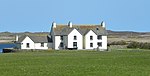
Name Location Date Listed Grid Ref. [note 1] Geo-coordinates Notes LB Number [note 2] Image Hynish, Harbour And Lighthouse Establishment, Including Signal Tower, Housing, Sheds/Stores, Dam And Walled Enclosures 56°26′52″N 6°53′40″W / 56.447805°N 6.894556°W / 56.447805; -6.894556 (Hynish, Harbour And Lighthouse Establishment, Including Signal Tower, Housing, Sheds/Stores, Dam And Walled Enclosures ) Category A 17848 Upload another image
Balevullin Cottage Owned By Frances Walker 56°31′00″N 6°57′11″W / 56.516798°N 6.953088°W / 56.516798; -6.953088 (Balevullin Cottage Owned By Frances Walker ) Category B 17852 Kilkenneth 56°29′39″N 6°57′58″W / 56.494255°N 6.966245°W / 56.494255; -6.966245 (Kilkenneth ) Category B 17862 The Green 56°31′40″N 6°56′03″W / 56.527696°N 6.934066°W / 56.527696; -6.934066 (The Green ) Category B 17864 Mannal 56°27′40″N 6°53′35″W / 56.461192°N 6.893194°W / 56.461192; -6.893194 (Mannal ) Category B 17866 Heanish, Brandon Cottage 56°29′31″N 6°48′53″W / 56.491945°N 6.814838°W / 56.491945; -6.814838 (Heanish, Brandon Cottage ) Category B 19836 Sandaig, The Terrace (South End Dwelling) 56°28′53″N 6°58′18″W / 56.481374°N 6.971777°W / 56.481374; -6.971777 (Sandaig, The Terrace (South End Dwelling) ) Category C(S) 18476 St Columba's Chapel, Near Kirkapol Burial Ground 56°31′29″N 6°48′42″W / 56.524857°N 6.811745°W / 56.524857; -6.811745 (St Columba's Chapel, Near Kirkapol Burial Ground ) Category B 17842 St. Kenneth's Chapel (Cill Choinnich) Kilkenneth Burial Ground 56°29′44″N 6°58′07″W / 56.495577°N 6.968728°W / 56.495577; -6.968728 (St. Kenneth's Chapel (Cill Choinnich) Kilkenneth Burial Ground ) Category B 17847 4 Balevullin 56°30′51″N 6°56′42″W / 56.51428°N 6.944931°W / 56.51428; -6.944931 (4 Balevullin ) Category B 18477 Dun Beag Cottage, (L Maclean) Scarinish 56°30′07″N 6°48′30″W / 56.502026°N 6.808212°W / 56.502026; -6.808212 (Dun Beag Cottage, (L Maclean) Scarinish ) Category B 17845 Barrapol Clachan Dubh 56°28′46″N 6°57′27″W / 56.479454°N 6.95751°W / 56.479454; -6.95751 (Barrapol Clachan Dubh ) Category B 17853 Ruaig 5A, B, C, D, E Brock 56°31′39″N 6°46′20″W / 56.527364°N 6.772248°W / 56.527364; -6.772248 (Ruaig 5A, B, C, D, E Brock ) Category B 17867 Hynish, Hynish Farm Steading 56°26′48″N 6°53′49″W / 56.446715°N 6.896852°W / 56.446715; -6.896852 (Hynish, Hynish Farm Steading ) Category C(S) 49356 Sandaig, The Terrace (North End And Centre Dwellings) 56°28′53″N 6°58′19″W / 56.481513°N 6.971909°W / 56.481513; -6.971909 (Sandaig, The Terrace (North End And Centre Dwellings) ) Category B 18475 3 Kilmoluaig 56°30′20″N 6°55′45″W / 56.505487°N 6.929189°W / 56.505487; -6.929189 (3 Kilmoluaig ) Category A 17857 3 Moss 56°29′14″N 6°56′29″W / 56.487159°N 6.94141°W / 56.487159; -6.94141 (3 Moss ) Category B 17860 Balmartine Tigh Fiona Ghall 56°28′08″N 6°53′47″W / 56.469014°N 6.896511°W / 56.469014; -6.896511 (Balmartine Tigh Fiona Ghall ) Category B 17863 The Green 56°31′42″N 6°56′04″W / 56.528272°N 6.934499°W / 56.528272; -6.934499 (The Green ) Category B 17865 Cornaig, Congregational Church 56°31′16″N 6°54′23″W / 56.520988°N 6.906304°W / 56.520988; -6.906304 (Cornaig, Congregational Church ) Category C(S) 50169 Upload another image
Island House, Loch An Eilean, Heylipol 56°29′13″N 6°53′53″W / 56.48706°N 6.898157°W / 56.48706; -6.898157 (Island House, Loch An Eilean, Heylipol ) Category B 19834 Upload another image
Barrapol (Hector Mcneill) 56°28′15″N 6°57′12″W / 56.470757°N 6.953367°W / 56.470757; -6.953367 (Barrapol (Hector Mcneill) ) Category B 17854 13 Kilmoluaig 56°30′32″N 6°55′31″W / 56.509013°N 6.925157°W / 56.509013; -6.925157 (13 Kilmoluaig ) Category A 17859 Barrapol (Morvan House) Or 'Drover's 56°28′48″N 6°57′00″W / 56.479983°N 6.949889°W / 56.479983; -6.949889 (Barrapol (Morvan House) Or 'Drover's ) Category B 17861 Tiree Parish Church Kirkapol 56°31′12″N 6°48′48″W / 56.519888°N 6.813197°W / 56.519888; -6.813197 (Tiree Parish Church Kirkapol ) Category B 17594 Upload another image See more images
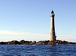
Kirkapol Chapel (St Peter's) Cladh Beag, Kirkapol Burial Ground 56°31′27″N 6°48′41″W / 56.524147°N 6.811264°W / 56.524147; -6.811264 (Kirkapol Chapel (St Peter's) Cladh Beag, Kirkapol Burial Ground ) Category B 17595 Skerryvore Lighthouse 56°19′23″N 7°06′58″W / 56.323118°N 7.11624°W / 56.323118; -7.11624 (Skerryvore Lighthouse ) Category A 17849 Upload another image See more images
Cottages, (John Henderson's) Moss 56°29′37″N 6°56′29″W / 56.493477°N 6.941371°W / 56.493477; -6.941371 (Cottages, (John Henderson's) Moss ) Category B 17846 7 Balevullin (Cameron) 56°30′36″N 6°56′49″W / 56.509971°N 6.946939°W / 56.509971; -6.946939 (7 Balevullin (Cameron) ) Category B 17850 Kenovay, (Crawford) 56°30′42″N 6°53′09″W / 56.511796°N 6.885733°W / 56.511796; -6.885733 (Kenovay, (Crawford) ) Category B 17856 Balmartine 56°28′05″N 6°53′50″W / 56.46793°N 6.897297°W / 56.46793; -6.897297 (Balmartine ) Category B 19835 Scarinish 56°29′59″N 6°48′37″W / 56.499713°N 6.81031°W / 56.499713; -6.81031 (Scarinish ) Category B 19837 Tishabet, Formerly (Tiree Manse) Gott 56°30′37″N 6°48′28″W / 56.510359°N 6.807691°W / 56.510359; -6.807691 (Tishabet, Formerly (Tiree Manse) Gott ) Category B 17843 Pierview Cottage (J Maclean's) Scarinish 56°30′09″N 6°48′31″W / 56.502374°N 6.808744°W / 56.502374; -6.808744 (Pierview Cottage (J Maclean's) Scarinish ) Category B 17844 Balevullin Creag Chrom 56°31′10″N 6°57′26″W / 56.519308°N 6.957355°W / 56.519308; -6.957355 (Balevullin Creag Chrom ) Category B 17851