Related Research Articles

The Grampians National Park commonly referred to as the Grampians, is a national park located in the Grampians region of Victoria, Australia. The Jardwadjali name for the mountain range itself is Gariwerd.

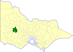
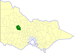
The Shire of Northern Grampians is a local government area in the Wimmera region of Victoria, Australia, located in the western part of the state. It covers an area of 5,730 square kilometres (2,210 sq mi) and in June 2018 had a population of 11,431, having fallen from 12,087 in 2008. It includes the towns of Stawell, St Arnaud, Great Western, Marnoo, Glenorchy, Stuart Mill, Navarre and the tourist town of Halls Gap. It was formed in 1995 from the amalgamation of the City of Stawell, Town of St Arnaud, Shire of Stawell, Shire of Kara Kara and parts of the Shire of Wimmera, Shire of Dunmunkle and Shire of Donald.

Stawell, is an Australian town in the Wimmera region of Victoria 237 kilometres (147 mi) west-north-west of the state capital, Melbourne. Located within the Shire of Northern Grampians local government area, it is a seat of local government for the shire and its main administrative centre. At the 2021 census, Stawell had a population of 6,220.

The Victorian government's Wimmera Southern Mallee subregion is part of the Grampians region in western Victoria. It includes most of what is considered the Wimmera, and part of the southern Mallee region. The subregion is based on the social catchment of Horsham, its main settlement.

Blacktown City Council is a local government area in Western Sydney, situated on the Cumberland Plain, approximately 35 kilometres (22 mi) west of the Sydney central business district, in the state of New South Wales, Australia. Established in 1906 as the Blacktown Shire and becoming the Municipality of Blacktown in 1961 before gaining city status in 1979, the City occupies an area of 246.9 square kilometres (95.3 sq mi) and has a population of 366,534, making it the second most populous local government area in Sydney.
The Stawell Gift is Australia's oldest and richest short-distance running race. It is the main event in an annual carnival held on Easter weekend by the Stawell Athletic Club, with the main race finals on the holiday Monday, at Central Park, Stawell in the Grampian Mountains district of western Victoria. As of 2016 the carnival encompasses events for both men and women of all ages and abilities, across distances from 70 to 3,200 metres.
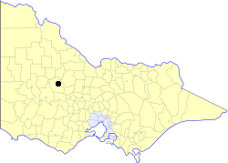
The Shire of Stawell was a local government area about 230 kilometres (143 mi) west-northwest of Melbourne, the state capital of Victoria, Australia. The shire covered an area of 2,606 square kilometres (1,006.2 sq mi), and existed from 1861 until 1995.
The Shire of Kara Kara was a local government area about 240 kilometres (149 mi) northwest of Melbourne, the state capital of Victoria, Australia. The shire covered an area of 2,292.79 square kilometres (885.3 sq mi), and existed from 1861 until 1995.
The Town of St Arnaud was a local government area about 240 kilometres (149 mi) northwest of Melbourne, the state capital of Victoria, Australia. The town covered an area of 25.92 square kilometres (10.0 sq mi), and existed from 1861 until 1994. Its area was surrounded by the Shire of Kara Kara.
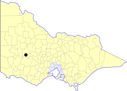
The City of Stawell was a local government area about 230 kilometres (143 mi) west-northwest of Melbourne, the state capital of Victoria, Australia. The city covered an area of 23.73 square kilometres (9.2 sq mi), and existed from 1869 until 1995. Its area was surrounded by the separate and largely rural Shire of Stawell.

John Keith McDougall, also known as J. K. McDougall, was an Australian politician, poet and Labor activist.

The City of Warwick was a local government area administering the regional centre of Warwick in the Darling Downs region of Queensland. The City covered an area of 25.1 square kilometres (9.7 sq mi), and existed as a local government entity from 1861 until 1994, when it was dissolved and amalgamated with Shire of Allora, Shire of Rosenthal and Shire of Glengallan to form the Shire of Warwick.

A moderately extensive bushfire season, particularly in western Victoria where fires were most prominent, occurred in mid-late January 2006 as conditions persisted across the state.
Nelson Province was an electorate of the Victorian Legislative Council (Australia). It was created in the wide-scale redistribution of Provinces 1882 when Central and Eastern Provinces were abolished and ten new Provinces were created. Its area included Camperdown, Ararat and Mortlake.
The Stawell Underground Physics Laboratory (SUPL) is a laboratory 1 km deep in the Stawell Gold Mine, located in Stawell, Shire of Northern Grampians, Victoria, Australia. Together with the planned Agua Negra Deep Experiment Site (ANDES) at the Agua Negra Pass, it is one of just two underground particle physics laboratories in the Southern Hemisphere and shall conduct research into dark matter.
Australian Community Media (ACM) is a media company in Australia responsible for over 160 regional publications. Its mastheads include the Canberra Times, Newcastle Herald, The Examiner, The Border Mail, The Courier and the Illawarra Mercury along with more than one hundred community-based websites across Australia and numerous agricultural publications including The Land and Queensland Country Life.

Callawadda is a locality in the Wimmera region of western Victoria, Australia. The locality is in the Shire of Northern Grampians, 262 kilometres (163 mi) west of the state capital, Melbourne.
Mount Zero, also known as Mura Mura in the Jardwadjali language is the northernmost mountain of the Grampian range. Its prominent conical shape is visible from the Western Highway south of Horsham. Scottish explorer Sir Thomas Livingstone Mitchell named and then described the mountain as "Mount Zero, a name I applied to a remarkable cone at the western extermity of the chain of mountains." While the peak is inside the National Park, the Mount Zero Olive Farm runs along its northern approaches. Scrub covers the sandstone slopes, with a track running up to the summit from the Mt Zero Picnic Area.

John R D'Alton (1829–1904) was an engineer who migrated to Australia from Tipperary, Ireland in 1861 following his brother, William (1833–1907) who migrated in 1855. He worked as a mining surveyor at Ararat, Victoria before moving to Stawell, Victoria. He was the Borough engineer as well as the town valuer, surveyor and designer of several buildings, including the town hall built in 1870.
References
- ↑ Annual Town and Borough, Council Meetings The Argus, 20 November 1873
- ↑ The Municipal Elections The Argus, 17 August 1875
- ↑ The Mayoral Elections The Argus,19 August 1879
- ↑ Donation made to Historical Society Archived 6 July 2011 at the Wayback Machine The Stawell Times News, 14 July 2009
- ↑ Stawell Mayor The Argus, 3 September 1952
- ↑ Mayor predicts bright future for municipality Archived 6 July 2011 at the Wayback Machine The Stawell Times News, 9 December 2008
- ↑ Ray Hewitt new Mayor for Northern Grampians Archived 6 July 2011 at the Wayback Machine The Stawell Times News, 7 December 2010