List of mountain peaks in the Greater Blue Mountains Area:
List of mountain peaks in the Greater Blue Mountains Area:

The Blue Mountains are a mountainous region and a mountain range located in New South Wales, Australia. The region is considered to be part of the western outskirts of the Greater Sydney area. The region borders on Sydney's main metropolitan area, its foothills starting about 50 kilometres (31 mi) west of centre of the state capital, close to Penrith. The public's understanding of the extent of the Blue Mountains is varied, as it forms only part of an extensive mountainous area associated with the Great Dividing Range. As defined in 1970, the Blue Mountains region is bounded by the Nepean and Hawkesbury rivers in the east, the Coxs River and Lake Burragorang to the west and south, and the Wolgan and Colo rivers to the north. Geologically, it is situated in the central parts of the Sydney Basin.

The Blue Mountains National Park is a protected national park that is located in the Blue Mountains region of New South Wales, in eastern Australia. The 267,954-hectare (662,130-acre) national park is situated approximately 80 kilometres (50 mi) west of Sydney, and the park boundary is quite irregular as it is broken up by roads, urban areas and inholdings. Despite the name mountains, the area is an uplifted plateau, dissected by a number of larger rivers. The highest point in the park is Mount Werong at 1,215 metres (3,986 ft) above sea level; while the low point is on the Nepean River at 20 metres (66 ft) above sea level as it leaves the park.

Mount Warning, a mountain in the Tweed Range in the Northern Rivers region of New South Wales, Australia, was formed from a volcanic plug of the now-gone Tweed Volcano. The mountain is located 14 kilometres (9 mi) west-south-west of Murwillumbah, near the border between New South Wales and Queensland. Lieutenant James Cook saw the mountain from the sea and named it Mount Warning.
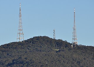
Mount Sugarloaf, also known as Great Sugar Loaf, is a mountain in the lower Hunter Region of New South Wales, Australia, standing at 412 meters, it looks over the cities of Newcastle, Lake Macquarie, Cessnock and Maitland. The summit of the mountain is in the Lake Macquarie suburb of West Wallsend and access to the summit is gained via this suburb. However, the mountain itself is also part of the city of Cessnock suburbs Mulbring and Richmond Vale. It is home to television transmitters that broadcast to the lower Hunter region. On 18 and 19 July 1965, the mountain received 10 centimetres (4 in) of snow. It also snowed on the summit in the winter of 1975.

The City of Blue Mountains is a local government area of New South Wales, Australia, governed by the Blue Mountains City Council. The city is located in the Blue Mountains, on the Great Dividing Range at the far western fringe of the Greater Sydney area.

Mount Victoria is a small township in the Blue Mountains of New South Wales, Australia. Mount Victoria is geographically the western most village and suburb of Greater Sydney on the great western highway in the City of Blue Mountains, located about 120 kilometres (75 mi) west-northwest by road from the Sydney central business district and at an altitude of about 1,052 metres (3,451 ft) AHD . The settlement had a population of 823 people at the 2011 Census.

Mount Duval, a large forested mountain of the New England Range, part of the Great Dividing Range, is located on the Northern Tablelands in the New England region of New South Wales, Australia.

The Watagan Mountains or Watagans or Wattagan Mountains, is a mountain range which is part of the Great Dividing Range that’s located in the hinterlands of the Hunter and Central Coast regions of New South Wales, Australia. The range is situated between the Upper Hunter River catchment and the Tuggerah Lakes with close proximity to Lake Macquarie. The Watagans are a popular tourist location and are close to regional centres like Newcastle and Gosford.

Mount Wilson is a village located in the Blue Mountains region of New South Wales, Australia. The village is about 14 kilometres (8.7 mi) east of the township of Bell, and about 100 kilometres (62 mi) west of the Sydney CBD. At the 2021 census, the village of Mount Wilson had a population of 81 people.
Mount Tomah is a locality and a mountain that is located in the Blue Mountains region of the state of New South Wales, Australia. The locality is known for the Blue Mountains Botanic Garden on the Bells Line of Road.

Mount York, a mountain in the western region of the Explorer Range, part of the Blue Mountains Range that is a spur off the Great Dividing Range, is located approximately 150 kilometres (93 mi) west of Sydney, just outside Mount Victoria in New South Wales, Australia. Mount York has an elevation of 1,061 metres (3,481 ft) AHD and is a projection of the Blue Mountains dissected plateau, creating a promontory of the western escarpment with a minor rise at its summit.

Mount Piddington (Aboriginal: Wirindi, a mountain in the Explorer Range of the Blue Mountains region, is located south of the village of Mount Victoria in New South Wales, Australia.
Mount Boyce is a hill standing approximately 1,093 metres (3,586 ft) AMSL, situated as one of the highest points on a plateau within the Explorer Range, part of the Blue Mountains Range which is a spur off the Great Dividing Range. Mount Boyce is located 2 kilometres (1.2 mi) north of Blackheath, in New South Wales, Australia.

The Mount Royal Range is a mountain range in the Hunter region of New South Wales, Australia.

Mount Yengo is a mountain that is located in the Lower Hunter region of New South Wales, in eastern Australia. The 668-metre (2,192 ft) mountain is part of the Calore Range, part of the Great Dividing Range, and is situated within the Yengo National Park, approximately 3 kilometres (1.9 mi) east of the Macdonald River and 17 kilometres (11 mi) east by south of Putty.

The Nandewar Range, a mountain range that is part of the Great Dividing Range, is located in the North West Slopes region of New South Wales, Australia. The range is situated approximately 30 km (19 mi) east of the township of Narrabri.

Mount Twynam is a mountain located on the Main Range, part of the Great Dividing Range, in the Snowy Mountains in New South Wales, Australia. The mountain is located close the border between New South Wales and Victoria.

Mount Banks, a mountain within the Explorers Range of the Blue Mountains Range that is a spur off the Great Dividing Range, is located within the Blue Mountains National Park, approximately 100 kilometres (62 mi) west of Sydney in New South Wales, Australia. Mount Banks is located 8 kilometres (5.0 mi) from the nearest residential area, Mount Tomah, has an elevation of 1,049 metres (3,442 ft) AMSL, and can be accessed relatively easily via the Bells Line of Road.

Mount Hay, a mountain that is part of the Mt Hay Range of the Blue Mountains Range which is a spur off the Great Dividing Range, is located in the Blue Mountains National Park, New South Wales, Australia. It is located approximately 100 kilometres (62 mi) west of Sydney and 10 kilometres (6.2 mi) north of the nearest town, Wentworth Falls. Mount Hay is approximately 944 metres (3,097 ft) AMSL and is one of several basalt caps located within the UNESCO World Heritage Greater Blue Mountains Area.

Mount Banda Banda, a mountain of the Mid North Coast region of New South Wales, Australia, is situated 320 kilometres (200 mi) from Sydney within the Willi Willi National Park. Banda Banda can be seen on the north-western horizon from Port Macquarie, as well as on the south-western horizon 39 km from the town of Kempsey. At 1,258 metres (4,127 ft) AHD it is the highest mountain in the region.