Paterson is the largest city in and the county seat of Passaic County, New Jersey, United States.

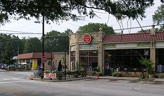
Poncey–Highland is an intown neighborhood on the east side of Atlanta, Georgia, located south of Virginia–Highland. It is so named because it is near the intersection of east/west Ponce de Leon Avenue and north/southwest North Highland Avenue. This Atlanta neighborhood was established between 1905 and 1930, and is bordered by Druid Hills and Candler Park across Moreland Avenue to the east, the Old Fourth Ward across the BeltLine Eastside Trail to the west, Inman Park across the eastern branch of Freedom Parkway to the south, and Virginia Highland to the north across Ponce de Leon Avenue. The Little Five Points area sits on the border of Poncey–Highland, Inman Park, and Candler Park.

Oakhurst is a historic neighborhood in the southwest corner of Decatur, Georgia, a suburb of Atlanta, Georgia. It is located south of downtown Decatur and approximately six miles east of downtown Atlanta. Oakhurst primarily consists of residences built in early 20th century and neighborhood businesses. It is roughly bounded by the City of Atlanta's Kirkwood neighborhood on the west ; the Atlanta city limits on the south; West College Ave. on the north; and South McDonough St. on the east. There is also a neighborhood near the College Heights Early Learning Center referred to as "College Heights", but it is part of Historic Oakhurst.

Hinchliffe Stadium is a 10,000-seat stadium located in Paterson, New Jersey. The venue was completed in 1932 and sits on a dramatic escarpment above Paterson's National Historic Landmark Great Falls, and surrounded by the city's national landmark historic district, the first planned industrial settlement in the nation. Hinchliffe stadium is know for holding auto racing as was its intended purpose. It is better remembered as a race track. It is one of only a handful of stadiums surviving nationally that once played host to significant Negro league baseball during America's Jim Crow era. The stadium was designated a National Historic Landmark in March 2013 and a Paterson Historic Landmark in May 2013. In December 2014, Congress passed legislation to include the stadium in the Great Falls National Landmark District.

Eastside High School is a four–year public high school located in Paterson section of Passaic County, New Jersey, United States, that serves the eastern section of Paterson. EHS, which serves ninth through twelfth grade students, operates as part of the Paterson Public Schools. The school has been accredited by the Middle States Association of Colleges and Schools Commission on Elementary and Secondary Schools since 1928. Eastside High School opened on February 1, 1926.

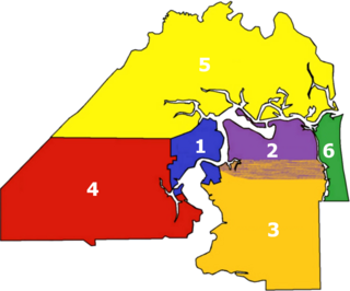
There are more than 500 neighborhoods within the area of Jacksonville, Florida, the largest city in the contiguous United States by area. These include Downtown Jacksonville and surrounding neighborhoods. Additionally, greater Jacksonville is traditionally divided into several major sections with amorphous boundaries: Northside, Westside, Southside, and Arlington, as well as the Jacksonville Beaches.

Buckman is a neighborhood in the Southeast section of Portland, Oregon. The neighborhood is bounded by the Willamette River on the west, E Burnside St. on the north, SE 28th Ave. on the east, and SE Hawthorne Blvd. on the south.

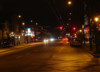
Main Street is a major north–south thoroughfare bisecting Vancouver, British Columbia, Canada. It runs from Waterfront Road by Burrard Inlet in the north, to Kent Avenue alongside the north arm of the Fraser River in the south.

Downtown Paterson is the main commercial district of Paterson, Passaic County, New Jersey, United States. The area is the oldest part of the city, along the banks of the Passaic River and its Great Falls. It is roughly bounded by Interstate 80, Garret Mountain Reservation, Route 19, Oliver Street, and Spruce Street on the south; the Passaic River, West Broadway, Cliff Street, North 3rd Street, Haledon Avenue, and the borough of Prospect Park on the west; and the Passaic River also to the north.
Eastside is a neighborhood in Paterson, New Jersey, United States. It is bordered by South Paterson, Downtown Paterson, Riverside and the Passaic River It is bound by 10th Avenue and Montgomery Street to the north, Straight Street to the west, I-80 to the south and the river to the east. It is Paterson's largest neighborhood and includes the smaller neighborhoods of Sandy Hill, People's Park, Eastside Park Historic District and the Manor Section. Eastside is a mostly residential area with commercial centers along 33rd Street and Broadway. It is also home to Eastside Park, Paterson's largest park.

Eastside Park is a residential neighborhood in the Eastside of Paterson, New Jersey. The Eastside Park section of the city is generally defined as the area of the city bordered by Vreeland Avenue and East 33rd Street to the west, 20th Avenue to the south, McLean Boulevard to the east, and Martin Luther King, Jr. Way (Broadway) to the north. The Eastside Park section is delineated from the Manor section of the city by Broadway, which becomes Route 4 before crossing the Passaic River into Elmwood Park in Bergen County.

People's Park is a section of Paterson, New Jersey, United States, in the Eastside neighborhood. It is a mixed use area with a diverse population. It is roughly bounded by I-80 to the south, Madison Avenue to the west and Market Street to the north. It is a mostly residential neighborhood located north of 23rd Avenue and South of Market Street.
The Old Great Falls Historic District is an area of Paterson, New Jersey between South Paterson and Hillcrest, Paterson. The area is a thin strip of neighborhoods and parklands around the Passaic River and Garret Mountain. This section of Paterson has two National Natural Landmarks, Garret Mountain and Great Falls on the Passaic. It is the location of the highest point in Paterson. It is home to Lambert Castle and Alexander Hamilton's Society for the Establishment of Useful Manufactures (S.U.M.), which used the force of Great Falls to power the mills along the Passaic in the Dublin section. The neighborhood is also home to part of Garret Mountain Reservation and Overlook Park around the Grand Street Reservoir. The neighborhood is bounded by the border with Hillcrest by the Passaic River, by the Woodland Park border, the South Paterson border along Valley Road and Route 19. It is separated from Downtown Paterson to the north by Route 19, Oliver Street and Spruce Street.

The Old Fourth Ward, often abbreviated O4W, is an intown neighborhood on the eastside of Atlanta, Georgia, United States. The neighborhood is best known as the location of the Martin Luther King Jr. historic site.

County Route 617 is 4.55 miles (7.32 km) long and follows one street, Summit Avenue along the ridge of the Hudson Palisades in Hudson County, New Jersey. Its southern end is CR 622, or Grand Street, at Communipaw Junction in the Bergen-Lafayette Section of Jersey City. Its northern end is CR 691, 32nd Street, a section of the Bergen Turnpike, in Union City.

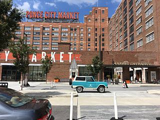
Eastside refers to the city district comprising the easternmost portion of Atlanta, Georgia, United States. The Eastside generally encompasses the area bounded on the west by Midtown Atlanta and Downtown Atlanta and on the east by the city limits. The central corridor of the district is the BeltLine Eastside Trail, which connects northern Eastside neighborhoods with those to the south. The Eastside is known for its nightlife establishments, craftsman architecture, local eateries, and quirky public art.
Fred Wesley Wentworth was an American architect known for his many buildings in Downtown Paterson, New Jersey as well as several residences and theaters in northeastern New Jersey. Wentworth had a major impact on shaping Paterson after a wind-driven fire decimated much of the central business district in 1902. His body of work consisted of institutional, commercial, residential, religious and healthcare buildings as well as some of the nation's first movie theaters designed exclusively for motion pictures. He was a Fellow of the American Institute of Architects.

Eastside Park is a park located in Paterson, New Jersey. The park is bordered by Martin Luther King, Jr. Way (Broadway) to the north, McLean Boulevard to the east, Park Avenue to the south, and Derrom Avenue to the west. Eastside Park is the cornerstone of the Eastside Park Historic District, a state and nationally registered historic place added to the National Register of Historic Places on July 7, 2004.

Andrew Derrom was an English-American civil engineer, industrialist, inventor, and military officer.