Related Research Articles

Montserrat is a British Overseas Territory in the Caribbean. It is part of the Leeward Islands, the northern portion of the Lesser Antilles chain of the West Indies. Montserrat is about 16 km (10 mi) long and 11 km (7 mi) wide, with roughly 40 km (25 mi) of coastline. It is nicknamed "The Emerald Isle of the Caribbean" both for its resemblance to coastal Ireland and for the Irish ancestry of many of its inhabitants. Montserrat is the only non-fully sovereign full member of the Caribbean Community and the Organisation of Eastern Caribbean States, though it is far from being the only dependency in the Caribbean overall. Staying a part of the United Kingdom proved especially fortuitous in the late 1990s, when the southern half the island had to be evacuated. Its capital and international airport were devastated by a volcanic eruption but many were able to travel to the U.K., which also helped rebuild. Within ten years important housing, government buildings, and a new airport were established in the north, though the population remains about one third of what it was before the eruption.

Montserrat is an island in the Caribbean Sea, in the Leeward Islands. Its nearest neighbours in the island chain include Guadeloupe to the southeast, Antigua to the north-east and Nevis to the northwest. The island is 16 km (9.9 mi) long and 11 km (6.8 mi) wide, with a coastline of about 40 km.

The economy of Montserrat is an economical system which was severely disrupted by volcanic activity which began in July 1995. Prior to this date, the small island country of 12,000 had an export economy based on agriculture, clothing, electronic parts and plants, with a per capita gross national product of US$3,000 to 8,000.
Railways: 0 km

A volcano is a rupture in the crust of a planetary-mass object, such as Earth, that allows hot lava, volcanic ash, and gases to escape from a magma chamber below the surface. The process that forms volcanoes is called volcanism.
Plymouth is a ghost town and the de jure capital of the island of Montserrat, an overseas territory of the United Kingdom located in the Leeward Island chain of the Lesser Antilles, West Indies. Plymouth is still the de jure capital of Montserrat, making it the only ghost town that is the capital of a political territory.

The Soufrière Hills is an active, complex stratovolcano with many lava domes forming its summit on the Caribbean island of Montserrat. After a long period of dormancy, the Soufrière Hills volcano became active in 1995 and continued to erupt through 2010. Its last eruption was in 2013. Its eruptions have rendered more than half of Montserrat uninhabitable, destroying the capital city, Plymouth, and causing widespread evacuations: about two-thirds of the population have left the island. Chances Peak in the Soufrière Hills was the highest summit on Montserrat until the mid-1990s, but it has since been eclipsed by various rising and falling volcanic domes during the recent volcanic activity.

In volcanology, a lava dome is a circular, mound-shaped protrusion resulting from the slow extrusion of viscous lava from a volcano. Dome-building eruptions are common, particularly in convergent plate boundary settings. Around 6% of eruptions on Earth form lava domes. The geochemistry of lava domes can vary from basalt to rhyolite although the majority are of intermediate composition The characteristic dome shape is attributed to high viscosity that prevents the lava from flowing very far. This high viscosity can be obtained in two ways: by high levels of silica in the magma, or by degassing of fluid magma. Since viscous basaltic and andesitic domes weather fast and easily break apart by further input of fluid lava, most of the preserved domes have high silica content and consist of rhyolite or dacite.

Brades is a town and the de facto capital of Montserrat since 1998 with an approximate population of 1,000.

A cinder cone is a steep conical hill of loose pyroclastic fragments, such as volcanic clinkers, volcanic ash, or scoria that has been built around a volcanic vent. The pyroclastic fragments are formed by explosive eruptions or lava fountains from a single, typically cylindrical, vent. As the gas-charged lava is blown violently into the air, it breaks into small fragments that solidify and fall as either cinders, clinkers, or scoria around the vent to form a cone that often is symmetrical; with slopes between 30 and 40°; and a nearly circular ground plan. Most cinder cones have a bowl-shaped crater at the summit.
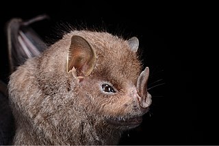
The Guadeloupe big-eyed bat is a species of bat in the family Phyllostomidae. It is found in Guadeloupe and Montserrat. It is threatened by habitat loss mostly because of Hurricane Hugo, which destroyed 90% of its population in 1989. The species may be locally extinct in some areas of Guadeloupe.

The volcanism of New Zealand has been responsible for many of the country's geographical features, especially in the North Island and the country's outlying islands.
The following outline is provided as an overview of and topical guide to Montserrat:

Music for Montserrat was a benefit concert held on 15 September 1997 at the Royal Albert Hall. The event was organised by Sir George Martin, former producer for The Beatles and founder of Associated Independent Recording, to raise funds for the Caribbean island of Montserrat after a major volcanic eruption by the Soufrière Hills volcano earlier that year.

Lava is molten or partially molten rock (magma) that has been expelled from the interior of a terrestrial planet or a moon onto its surface. Lava may be erupted at a volcano or through a fracture in the crust, on land or underwater, usually at temperatures from 800 to 1,200 °C. The volcanic rock resulting from subsequent cooling is also often called lava.

Barry Voight is an American geologist, volcanologist, author, and engineer. After earning his Ph.D. at Columbia University, Voight worked as a professor of geology at several universities, including Pennsylvania State University, where he taught from 1964 until his retirement in 2005. He remains an emeritus professor there and still conducts research, focusing on rock mechanics, plate tectonics, disaster prevention, and geotechnical engineering.

A multi-component gas analyzer system (Multi-GAS) is an instrument package used to take real-time high-resolution measurements of volcanic gases. A Multi-GAS package includes an infrared spectrometer for CO2, two electrochemical sensors for SO2 and H2S, and pressure–temperature–humidity sensors, all in a weatherproof box. The system can be used for individual surveys or set up as permanent stations connected to radio transmitters for transmission of data from remote locations. The instrument package is portable, and its operation and data analysis are simple enough to be conducted by non-specialists.
Jenni Barclay is a professor of volcanology at the University of East Anglia. She works on ways to mitigate volcanic risks, the interactions between rainfall and volcanic activity and the communication of volcanic hazards in the Caribbean. Barclay leads the NERC-ESRC funded Strengthening Resilience to Volcanic Hazards (STREVA) research project as well as a Leverhulme Trust programme looking at the volcanic history of the Ascension Islands.
Thomas Mylius Savage English was a British naturalist, who is notable for having identified the volcanic crater of the Soufrière Hills Volcano, Montserrat now known as English's Crater.
Susan Loughlin MBE is a British volcanologist. She was Director of the Montserrat Volcano Observatory from 2004-2006, and has been Head of Volcanology for the British Geological Survey since 2008.
References
- ↑ "Google Earth". earth.google.com. Retrieved 19 October 2020.
- ↑ Wilkinson, Emily (2021). "a consensus on tolerable levels of risk?". Rethinking Urban Risk and Resettlement in the Global South: 115–130. doi:10.2307/j.ctv1ctgr0k.14 – via JSTOR.
- ↑ Sword-Daniels, V.; Wilson, T. M.; Sargeant, S.; Rossetto, T.; Twigg, J.; Johnston, D. M.; Loughlin, S. C.; Cole, P. D. (23 January 2014). "Chapter 26 Consequences of long-term volcanic activity for essential services in Montserrat: challenges, adaptations and resilience". Geological Society, London, Memoirs. 39 (1): 471–488. doi:10.1144/M39.26 – via CrossRef.