This table shows an overview of the protected heritage sites in the Walloon town Raeren . This list is part of Belgium's national heritage.
| Object | Year/architect | Town/section | Address | Coordinates | Number | Image |
|---|---|---|---|---|---|---|
| Eynatten village center (nl)(de) | Raeren | 50°41′35″N6°04′47″E / 50.692993°N 6.079779°E | 31450 Info | 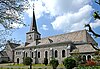 | ||
| St. Roch Chapel and surroundings (nl)(de) | Raeren | 50°42′05″N6°03′51″E / 50.701402°N 6.064134°E | 31383 Info |  | ||
| Cross "Hauseter Feld" (nl)(de) | Raeren | 50°41′45″N6°03′14″E / 50.695813°N 6.053890°E | 31384 Info |  | ||
| Zyklopensteine with surroundings (nl)(de) | Raeren | 50°43′13″N6°05′40″E / 50.720194°N 6.094579°E | 31434 Info |  | ||
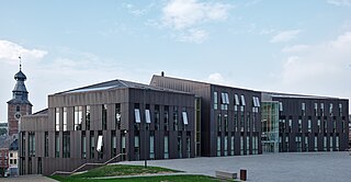
| St. Nicholas Church (nl)(de) | Raeren | 50°40′33″N6°06′39″E / 50.675818°N 6.110876°E | 31385 Info | 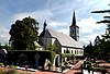 | ||
| St. Anne Chapel (nl)(de) | Raeren | 50°40′41″N6°07′32″E / 50.677985°N 6.125515°E | 31398 Info |  | ||
| Cross "Kule Kreuz" (nl)(de) | Raeren | 50°40′31″N6°06′39″E / 50.675275°N 6.110727°E | 31449 Info |  | ||
| Raeren Castle: tower and north wall with gate (nl)(de) | Raeren | 50°40′43″N6°07′14″E / 50.678749°N 6.120609°E | 31399 Info | 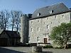 | ||
| Raeren house: walls, roof, moat and bridge (nl)(de) | Raeren | 50°40′41″N6°07′19″E / 50.678182°N 6.121958°E | 31400 Info |  | ||
| Amstenrath house and farm buildings (facades and roofs) and the cobblestone courtyard (nl)(de) | Raeren | 50°41′40″N6°04′56″E / 50.694392°N 6.082290°E | 31369 Info | 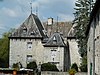 | ||
| "Hohe Brücke" area (nl)(de) | Raeren | 50°40′39″N6°07′06″E / 50.677405°N 6.118226°E | 31404 Info |  | ||
| Knoppenburg: two round towers, facades and roofs of the west wing and east wing, walls and roof of the residential building (except the two adjoining buildings on either side) and surroundings (nl)(de) | Raeren | 50°40′02″N6°05′58″E / 50.667161°N 6.099568°E | 31401 Info | 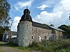 | ||
| House: walls and roof (nl)(de) | Raeren | Lichtenbuscher Strasse 19 | 50°41′35″N6°05′05″E / 50.693191°N 6.084757°E | 31371 Info |  | |
| "Der Vennbusch" (nl)(de) | Raeren | 50°39′41″N6°07′12″E / 50.661251°N 6.120078°E | 31058 Info |  | ||
| Hof Meurisse: walls, roofs, and cobblestone courtyard (nl)(de) | Raeren | 50°40′52″N6°08′34″E / 50.681068°N 6.142895°E | 31402 Info |  | ||
| House: walls and roof, fence wall with blue stone pillars and wrought iron gate (nl)(de) | Raeren | Eupener Strasse 8 | 50°41′31″N6°04′57″E / 50.691991°N 6.082626°E | 31376 Info |  | |
| Bergschied house: walls and roof of the main house and entrance gate (nl)(de) | Raeren | 50°40′17″N6°07′00″E / 50.671330°N 6.116574°E | 31403 Info | 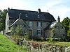 | ||
| Raaff Castle: The ruins of the tower (nl)(de) | Raeren | Berlotte | 50°41′52″N6°06′09″E / 50.697840°N 6.102505°E | 31381 Info |  | |
| Court Stester: walls and roofs (nl)(de) | Raeren | Berlotte | 50°41′56″N6°06′22″E / 50.698752°N 6.106124°E | 31382 Info | 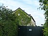 | |
| Brandheidchen (nl)(de) | Raeren | 50°42′15″N6°04′24″E / 50.704086°N 6.073438°E | 31057 Info |  | ||
| Der Leuff: walls and roof, and the stables: facades and roof (nl)(de) | Raeren | 50°41′32″N6°04′59″E / 50.692260°N 6.083049°E | 32237 Info |  | ||
| Saxby signal-box of former train station including the station and technical equipment (de) | Raeren | 50°39′52″N6°07′33″E / 50.664464°N 6.125862°E | 40366 Info | 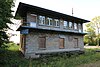 |