This is a list of public art in Hemel Hempstead , in Hertfordshire, England.
| Image | Title / subject depicted | Location | Date | Sculptor | Material | Source | Coordinates |
|---|---|---|---|---|---|---|---|
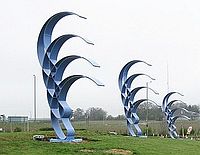 | Phoenix Gateway sculpture | Roundabout at the junction of the A414 and Green Lane | 2009 | Jose Zavala | Blue steel arches | [1] | 51°45′22″N0°25′26″W / 51.756246°N 0.423952°W |
 | Rock'n'Roll | The Water Gardens, Hemel Hempstead | 1962 | Hubert Yencesse | Bronze | [2] | 51°44′55″N0°28′26″W / 51.748499°N 0.474025°W |
 | Development of Man | Corner of Bridge Street above the Santander bank | 1955 | A H Gerrard | Portland stone | [3] | 51°45′04″N0°28′22″W / 51.751242°N 0.472672°W |
 | 'A Point for Reflection' - Associations with water for the Riverside Shopping Centre, a droplet of clouds, rain, swirling rivulets and weaving water weeds. | Marlowes at entrance to Riverside shopping development. | 2008 | Tim Shutter | Hand carved Perryfield Whitbed Portland Stone. | [4] | 51°44′52″N0°28′22″W / 51.747798°N 0.472687°W |
 | Tile Mosaic Map | Junction of the Marlowes and Hillfiled Road on the side of the NCP multistory car park. | 1960 | Rowland Emett | Mosaic | [5] | 51°45′10″N0°28′19″W / 51.752826°N 0.472083°W |
 | Reclining Figures | The corner of Jupiter Drive and Martian Avenue | 1962 | Sydney Harpley | Sculpture | [6] | 51°45′55″N51°45′55″E / 51.765221°N 51.765221°E |
| Boy with Cat | Hyperion Court Highfield, Hemel Hempstead | 1962 | John Mills | Sculpture | 51°46′01″N0°27′11″W / 51.766829°N 0.453060°W | ||
| Girl Combing Hair | Martian Avenue, Hemel Hempstead | 1962 | Sydney Harpley | Irish limestone Sculpture | 51°45′58″N0°27′04″W / 51.766146°N 0.450982°W | ||
| Mother and Child | St Nicholas Day Nursary, Eastwick Row, Hemel Hempstead | Not known | Not known | Steel frame stucco | [7] | 51°45′00″N0°26′57″W / 51.750045°N 0.449215°W | |
| Mother and Child | The Apple Orchard, Hemel Hempstead | Not known | Commissioned by Geoffrey Teychanne | [8] | 51°45′40″N0°27′14″W / 51.761°N 0.453781°W | ||
 | Discobolus: The Discus Thrower | N/A Formerly at the Water Gardens, due to be relocated to The Bury | pre 1960 | unknown | Bronze cast, Copy of 5th Century Greek marble | [9] | 51°44′58″N0°28′29″W / 51.749550°N 0.474656°W |
 | Residents Rainbow | Marlowes, Hemel Hempstead | 1993 | Colin Lambert Rainbow Mosaic added by Gary Drostle in 2010 | Concrete arch with mosaic | [10] | 51°44′57″N0°28′22″W / 51.749228°N 0.472639°W |
 | Waterplay The work symbolises the energy co-operation and sporting spirit of the youth in Dacorum. | Marlowes, Hemel Hempstead | 1993 | Michael Rizzello | Two water cascades and bronze sculpture of child gymnasts. | [11] | 51°44′58″N0°28′21″W / 51.749459°N 0.472457°W |
 | Bronze Relief Map of Town | Marlowes, Hemel Hempstead | 1992 | Graham Thompson (Designer) and John Ravera (Sculptor) | Bronze relief map | [12] | 51°45′00″N0°28′22″W / 51.749956°N 0.472672°W |
 | Replica Kangaroo, Joey and Platypus statues. A gift from the Australian New town of Elizabeth | The Water Gardens, Hemel Hempstead | 1963. | John Dowie | Bronze | [13] | 51°45′02″N0°28′27″W / 51.750659°N 0.474170°W |
| Tree of Life | Junction of Bridge Street and Marlowes | Richard Quinnell | Steel | [9] | |||
| Hugging Couple VIII | The Forget-Me-Not Memorial Garden for Babies, Gadebridge Park | Mark Humphrey | [14] [15] | ||||
| Unknown (Recalling Kodak's global association with the film industry) | Behind the KD Tower, Hemel Hempstead | 2010 | Unknown | Galvanised steel | [16] [17] | ||
| The Magic Roundabout | In green area in front of Mosaic House | 2011 | Gary Drostle | Porcelain Mosaic | 51°45'18.8"N 0°28'15.3"W |