List of saltpeter works in Tarapacá and Antofagasta

Last updated

The use of Nitratine or Chilean Saltpeter once an important source of nitrates for fertilizer and other chemical uses including gunpowder and fireworks.

Contents

The commencement of the export of nitrates to the Europe and the US in the 1830s marked the most important milestone in the history of the nitrate industry and brought consequences for the economies of the three countries sharing the Atacama Desert: Chile, Perú and Bolivia.

Antofagasta was founded in 1868, in October 1869 the extraction of nitrates commenced in Oficina Salar del Carmen, the first nitrate producing plant. In 1871, the Nitrate Railway was inaugurated, running from Iquique to La Noria in Peru. In 1873, the Peruvian Government established the Nitrate Trust (state monopoly), which was controlled from Tarapacá until the 1879–1883 "War of the Pacific". This political event was based on the boom of new "Oficinas salitreras" ("Saltpeter works") of quarrying nitratine to extract nitrate.

Since World War I the industry has been supplanted by fixing nitrogen from the air as the main source of nitrogen. [1] [2]

This is a list of saltpeter works in the Tarapacá and Antofagasta regions. The information regarding Saltpeter works on this page is compiled from the data supplied by the National Geospatial-Intelligence Agency, Country Files (GNS). [3] Unique Feature Identifier (UFI) is a number which uniquely identifies a Geoname feature. Same UFI means same feature.

1890 map of salpeter works in Tarapaca Mapa Oficinas Salitreras del norte de Chile (1890).jpg
1890 map of salpeter works in Tarapacá
List of Saltpeter works in Tarapacá and Antofagasta Region
OficinaLatitudeLongitudeUFI
Trinidad-19.550751-70.085782-894178
Paccha-19.565059-70.023938-894115
Jazpampa-19.572428-70.023959-894089
San Antonio de Zapiga-19.617482-69.978589-894147
Aragón-19.625763-69.959791-894032
Enriqueta-19.651981-69.961225-894076
Sacramento-19.658865-69.960986-894143
Carolina-19.666667-70.05-894055
San Patricio-19.671302-69.949181-894156
Los Pozos-19.673801-69.983738-894102
California-19.676873-70.049429-894048
Dolores-19.677805-69.945837-879800
Victoria-19.694192-70.011317-894184
Unión-19.70017-69.953725-894179
Sal dei Obispo-19.701493-69.970242-894165
Santa Rita-19.701493-69.970242-894165
Camiña-19.705671-69.917204-894050
Porvenir-19.714015-69.931426-894129
Limón-19.7-69.966667-894099
Ángela Vieja-19.741527-69.908196-894029
Chinquiquiray-19.744675-69.940149-894060
La Patria-19.755316-69.935761-894092
Aguada-19.774055-69.908088-894021
Asturias-19.787698-69.897289-894035
Amelia-19.837628-69.861603-894026
Aurora-19.845979-69.856975-894037
Mercedes-19.855886-69.859302-894109
Josefina-19.872306-69.82562-894090
Progreso-19.872555-69.835088-894131
Agua Santa-19.881435-69.876308-894022
Barcelona-19.888829-69.791632-873177
Slavia-19.891475-69.852938-894174
Primitiva-19.918645-69.804353-894130
Las Tres Marías-19.942453-69.813213-894094
Valparaíso-19.952048-69.830192-894181
San Jorge-19.958356-69.813581-894151
Santa Rosa de Huara-20.000584-69.781812-901160
Constancia-20.010831-69.775747-894065
Ramírez-20.050269-69.743608-894135
Santiago-20.051856-69.768544-894166
Mapocho-20.083333-69.75-894104
San Donato-20.108486-69.74967-894148
Peña Grande-20.116667-69.783333-894121
Baquedano-20.134625-69.755307-894042
San José-20.16164-69.777209-900430
Peña Chica, Oficina-20.166667-69.833333-895706
Kerima-20.177153-69.78238-885584
Peña Chica-20.180779-69.801984-894120
Humberstone (Ex-La Palma)-20.208047-69.795423-884741
Santa Laura -20.211143-69.812979-901026
Nebraska-20.2-69.85-893375
Cala-Cala-20.227976-69.799378-874636
Buen Retiro-20.233333-69.816667-894047
Carmen Bajo-20.273339-69.789996-894054
San Andrés-20.283333-69.783333-894145
San Manuel-20.287568-69.772137-894153
Serena-20.296056-69.775357-894172
San Esteban-20.316667-69.75-894150
Sara-20.325079-69.753255-894168
Las Carpas-20.333333-70.016667-887732
La Tirana-20.335518-69.656707-888534
Paposo-20.35-69.866667-894118
Limeña-20.366667-69.9-894098
Cholita-20.373378-69.878587-894061
Sebastopol-20.383333-69.916667-894171
Cóndor-20.392843-70.011505-894064
San Enrique-20.407103-69.84198-894149
Viga-20.414768-69.893692-894187
Sacramento-20.416667-69.833333-894142
San Pedro-20.416667-69.9-894157
San Antonio-20.416667-69.9-900125
Adriático-20.4-69.933333-894020
San Enrique-20.4-69.866667-900257
Victoria-20.433333-69.05-894185
Argentina-20.435847-69.864649-872551
Pirineo-20.449232-70.031223-894126
Santa Elena-20.45-69.783333-894161
Providencia-20.453338-69.993508-894133
San Pablo-20.457292-69.848845-894155
Ponte Vedra-20.460112-69.902208-894128
Diana-20.466667-69.766667-894070
Santa Ana-20.47645-69.905884-894159
Gloria Victoria-20.477913-69.953576-894084
Coruña-20.483333-69.883333-894067
Resurrección-20.483333-70-894137
San Lorenzo-20.483333-69.966667-894152
Virginia-20.483333-69.8-894188
Felisa-20.5-69.9-894080
San Remigio-20.5-69.9-894158
Santa Lucía-20.525699-69.959426-894164
Anita Pintados-20.548496-69.750143-894030
Mosquitos-20.554971-69.722058-893068
Gloria-20.574362-69.993051-894083
Mena Vilana-20.596196-69.702188-894112
Aurrera-20.642482-69.630034-894038
Pan de Azúcar-20.694895-69.734185-894117
Diez de Septiembre-20.696103-69.701583-894071
Victoria-20.716667-69.683333-894186
Brac-20.733333-69.7-904339
Victoria-20.733333-69.7-904339
Victoria-20.740547-69.659977-894183
Alianza-20.766667-69.7-871794
Pozo Granja-20.819409-69.540906-897214
Bellavista-20.82276-69.720449-894043
Buenaventura-20.835575-69.717824-874162
Slavonia-20.85-69.733333-894078
La Granja-20.902554-69.619369-886390
Iris-20.911023-69.632315-894088
Lagunas Norte-20.968118-69.67982-893853
Lagunas-20.982377-69.672023-876096
Lagunas Sur-20.999419-69.666116-886469
Andrés-21.858587-69.563535-894146
Santa Fé-21.86256-69.565618-894162
Joya-21.885144-69.434945-894091
Iberia-21.942359-69.594399-894087
Grutas-21.966667-69.616667-894086
Prosperidad-21.975523-69.607833-894132
Rica Aventura-21.985481-69.60945-894138
Esperanza Nitrate Company-22.016667-69.633333-874154
Buena Esperanza-22.022513-69.626972-894046
Empresa-22.038651-69.621618-894075
Peregrinos-22.066667-69.6-894122
Toco-22.070638-69.613741-894176
Santa Isabel-22.083333-69.6-894163
Santa Ana-22.116667-69.583333-894160
María Elena-22.344486-69.661775-894107
Coya (later María Elena)-22.416667-69.633333-894069
Vergara-22.466667-69.633333-894182
Pedro de Valdivia-22.597292-69.667393-894119
Los Dones-22.71236-69.775475-890182
Lina-22.823529-69.312331-894100
Higinio Astoreca-22.872456-69.818544-894025
Aconcagua-22.950104-69.372866-871203
Angamos-22.977802-69.463233-894028
Concepción-22.983333-69.383333-894063
Curicó-22.989206-69.391872-878180
Filomena-23.007874-69.408899-894081
Maria-23.033501-69.456395-894106
María-23.034766-69.455049-894105
Luisis-23.038865-69.518268-894103
Perseverancia-23.049155-69.397168-894123
Cecilia-23.05-69.516667-875984
Anita Antofagasta-23.059285-69.499304-894031
Ausonia-23.068968-69.542286-894039
Araucana-23.085246-69.450338-894033
Pinto-23.086443-69.510422-894125
Arturo Prat-23.100142-69.505954-894034
Carmela-23.104632-69.564754-894052
Edwards-23.120286-69.544241-894074
Ossa-23.130208-69.584115-894114
Ercilla-23.134143-69.875888-894077
Chacabuco -23.146229-69.617448-876218
Celia-23.148974-69.667476-894059
Aurelia-23.15-69.616667-894036
Carlos Condell-23.157893-69.679395-894051
Lastenia-23.166667-69.6-894093
Puelma-23.184007-69.662477-894134
Sargento Aldea-23.200132-69.686464-894169
Blanca Encalada-23.210429-69.618437-894044
Lautaro-23.519651-69.343335-894096
San Antonio-23.519651-69.343335-894096
Domeyko-23.783333-69.35-894072
Savona-23.785888-69.406553-894170
Pissis-23.8-69.366667-894127
Cochrane-23.823816-69.288788-894062
Castilla-23.899985-69.838636-894056
Americana-23.953655-69.772849-894027
Pampa Rica-24.050691-69.9351-894116
Oriente-24.055048-69.790865-894113
Yugoslavia-24.056345-69.829087-894190
Pepita-24.076474-69.865386-894068
Eugenia-24.133333-69.9-882460
Avanzada-24.137808-69.743245-894040
Petronila-24.15-69.85-896003
Esmeralda-24.156086-69.885505-894079
Eugenia-24.175166-69.869258-887038
Santiago-24.179758-69.917254-894167
María Teresa-24.20824-69.855852-894108
Renacimiento-24.224715-69.803595-894136
San Gregorio-24.224715-69.803595-894136
Bonasort-24.226065-69.894478-894045
San Martín-24.264648-69.826443-894154
Valparaíso-24.264648-69.826443-894154
Rosario-24.313322-69.970278-894140
Dominador-24.366667-69.516667-894073
Salinitas-25.04149-69.946783-894144
José Antonio Moreno-25.058774-69.880203-894111
Sud America-25.119174-69.661046-894175
Chile-25.15-69.9-876923
Alemania-25.155954-69.907162-894024
Atacama-25.201029-69.842443-872737
Caupolicán-25.2-69.716667-894058
Santa Luisa-25.232142-70.134263-882494
Rosario-25.240858-69.789199-894139
Portezuelo-25.295212-70.097356-897026
Ballena-25.305827-69.684102-894041
Flor de Chile-25.316667-69.8-894082
Lilita-25.323511-69.66812-894097
Esperanza-25.333333-69.733333-882317
Unión-25.340371-69.79449-894180
Tricolor-25.356213-69.886314-894177
Los Amigos-25.443238-69.929322-894101
Miraflores-25.444734-69.822048-894110
República-25.467907-69.801817-894173
Severín-25.467907-69.801817-894173
Catalina del Sur-25.494402-69.783583-894057
Some of the works can be found in the maps
19degS-20degS: Pisagua, Quebrada de Camarones, Caleta Junin, Of. Jazpampa, Of. Vieja Txu-oclc-224571178-se19-14.jpg
19°S-20°S: Pisagua, Quebrada de Camarones, Caleta Junin, Of. Jazpampa, Of. Vieja


20degS-21degS: Iquique, Huara, Pozo Almonte) Txu-oclc-224571178-sf19-02.jpg
20°S-21°S: Iquique, Huara, Pozo Almonte)


21degS-22degS: Rio Loa, Quillagua Txu-oclc-224571178-sf19-06.jpg
21°S-22°S: Río Loa, Quillagua
22degS-23degS: Tocopilla, Punta Hornos, Of. Maria Elena, Rio Loa Txu-oclc-224571178-sf19-10.jpg
22°S-23°S: Tocopilla, Punta Hornos, Of. María Elena, Río Loa
23degS-24degS: Antofagasta Costa Txu-oclc-224571178-sf19-14.jpg
23°S-24°S: Antofagasta Costa
23degS-24degS: Antofagasta interior, Toconao, Peine, Tilomonte, Salar de Atacama (sf19-15) Txu-oclc-224571178-sf19-15.jpg
23°S-24°S: Antofagasta interior, Toconao, Peine, Tilomonte, Salar de Atacama (sf19-15)


24degS-25degS: Punta Amarilla hasta Rada de Paposo Txu-oclc-224571178-sg19-02.jpg
24°S-25°S: Punta Amarilla hasta Rada de Paposo


25degS-26degS: Taltal, Chanaral, Parque Nacional Pan de Azucar (sg19-05) Txu-oclc-224571178-sg19-05.jpg
25°S-26°S: Taltal, Chañaral, Parque Nacional Pan de Azúcar (sg19-05)
25degS-26degS: Taltal, Oficina Chile Txu-oclc-224571178-sg19-06.jpg
25°S-26°S: Taltal, Oficina Chile

See also

Related Research Articles

<span class="mw-page-title-main">Antofagasta Region</span> Region of Chile

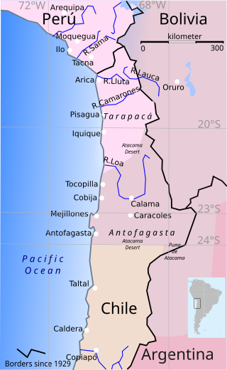
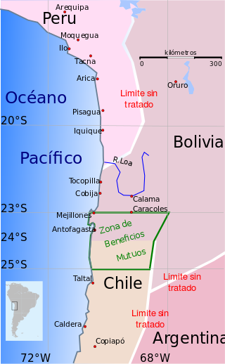
The Antofagasta Region is one of Chile's sixteen first-order administrative divisions. The second-largest region of Chile in area, it comprises three provinces, Antofagasta, El Loa and Tocopilla. It is bordered to the north by Tarapacá, by Atacama to the south, and to the east by Bolivia and Argentina. The region's capital is the port city of Antofagasta; another one of its important cities is Calama. The region's main economic activity is copper mining in its giant inland porphyry copper systems.

<span class="mw-page-title-main">War of the Pacific</span> Territorial conflict between Chile and allied Peru and Bolivia (1879–83)

The War of the Pacific, also known as the Nitrate War and by multiple other names, was a war between Chile and a Bolivian–Peruvian alliance from 1879 to 1884. Fought over Chilean claims on coastal Bolivian territory in the Atacama Desert, the war ended with victory for Chile, which gained a significant amount of resource-rich territory from Peru and Bolivia.

<span class="mw-page-title-main">Tarapacá Region</span> Region of Chile

The Tarapacá Region is one of Chile's 16 first-order administrative divisions. It comprises two provinces, Iquique and Tamarugal. It borders the Chilean Arica y Parinacota Region to the north, Bolivia's Oruro Department and Potosí Department on the east, Chile's Antofagasta Region to the south and the Pacific Ocean to the west. The port city of Iquique is the region's capital.

<span class="mw-page-title-main">Chacabuco</span> Abandoned town

Chacabuco is one of the many abandoned nitrate or "saltpeter" towns in the Atacama Desert of northern Chile. Other nitrate towns of the Atacama Desert include Humberstone and Santa Laura Saltpeter Works. Unlike most of the other ghost towns in the Atacama Desert, Chacabuco became a concentration camp during the Pinochet regime in 1973. To this day, it remains surrounded by approximately 98 lost landmines, left by the Chilean military when Chacabuco was used as a prison camp.

<span class="mw-page-title-main">Humberstone and Santa Laura Saltpeter Works</span> UNESCO World Heritage Site in Tarapacá Region, Chile

Humberstone and Santa Laura Saltpeter Works are two former saltpeter refineries located in northern Chile. They were declared a UNESCO World Heritage Site in 2005, as a testament to the historical importance of saltpeter mining in Chile and the culture and social agenda that developed around it in the late 19th century. The works were placed on the World Heritage List in Danger that same year, due to the fragility of the derelict buildings, but was removed in 2019.

<span class="mw-page-title-main">Nitratine</span> Mineral form of sodium nitrate

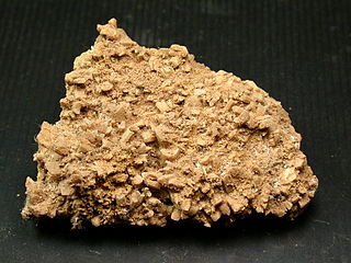
Nitratine or nitratite, also known as cubic niter (UK: nitre), soda niter or Chile saltpeter (UK: Chile saltpetre), is a mineral, the naturally occurring form of sodium nitrate, NaNO3. Chemically it is the sodium analogue of saltpeter. Nitratine crystallizes in the trigonal system, but rarely occurs as well formed crystals. It is isostructural with calcite. It is relatively soft and light with a Mohs hardness of 1.5 to 2 and a specific gravity of 2.24 to 2.29. Its refractive indices are nω = 1.587 and nε = 1.336.

<span class="mw-page-title-main">La Tirana</span> City and Commune in Tarapacá, Chile

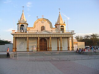
La Tirana is a Chilean town in the commune of Pozo Almonte in El Tamarugal Province, Tarapacá Region. The town lies in an oasis in the middle of the Pampa del Tamarugal, about 72 km inland from the port of Iquique.

<span class="mw-page-title-main">Santa María School massacre</span> 1907 massacre of mine workers in Chile

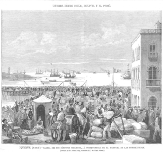
The Santa María School massacre was a massacre of striking workers, mostly saltpeter works (nitrate) miners, along with wives and children, committed by the Chilean Army in Iquique, Chile on December 21, 1907. The number of victims is undetermined but is estimated to be over 2,000. The massacre occurred during the peak of the nitrate mining era, which coincided with the Parliamentary Period in Chilean political history (1891–1925). With the massacre and an ensuing reign of terror, not only was the strike broken, but the workers' movement was thrown into limbo for over a decade. For decades afterwards, there was official suppression of knowledge of the incident, but in 2007 the government conducted a highly publicized commemoration of its centenary, including an official national day of mourning and the reinterment of the victims' remains.

<span class="mw-page-title-main">Atacama Desert</span> Desert in South America

The Atacama Desert is a desert plateau located on the Pacific coast of South America, in the north of Chile. Stretching over a 1,600 km (990 mi) strip of land west of the Andes Mountains, it covers an area of 105,000 km2 (41,000 sq mi), which increases to 128,000 km2 (49,000 sq mi) if the barren lower slopes of the Andes are included.

<span class="mw-page-title-main">María Elena, Chile</span> Town and Commune in Antofagasta, Chile

María Elena is a Chilean town and commune in Tocopilla Province, Antofagasta Region. According to the 2012 census, the commune population was 4,593 and has an area of 12,197.2 km2 (4,709 sq mi).

<span class="mw-page-title-main">Pulpería</span>

Pulpería was the name given to company stores and dining facilities in parts of South America, notably in the industries that extracted sodium nitrate from caliche deposits between 1850 and 1930 in Northern Chile in the current regions of Tarapaca and Antofagasta. The term was used in the Spanish colonial period in South America.

<span class="mw-page-title-main">Treaty of Defensive Alliance (Bolivia–Peru)</span> 1873 treaty between Peru and Bolivia

The Treaty of Defensive Alliance was a secret defense pact between Bolivia and Peru. Signed in the Peruvian capital, Lima, on February 6, 1873, the document was composed of eleven central articles that outlined its necessity and stipulations and one additional article that ordered the treaty to be kept secret until both contracting parties decided otherwise. The signatory states were represented by the Peruvian Foreign Minister José de la Riva-Agüero y Looz Corswaren and the Bolivian Envoy Extraordinary and Minister Plenipotentiary in Peru, Juan de la Cruz Benavente.

<span class="mw-page-title-main">Peruvian nitrate monopoly</span>

The Peruvian nitrate monopoly was a state-owned enterprise over the mining and sale of saltpeter created by the government of Peru in 1875 and operated by the Peruvian Nitrate Company. Peru intended for the monopoly to capitalize on the world market's high demand for nitrates, thereby increasing the country's fiscal revenues and supplementing the financial role that guano sales had provided for the nation during the Guano Era (1840s-1860s).

<span class="mw-page-title-main">Boundary Treaty of 1874 between Chile and Bolivia</span> 1874 treaty between Chile and Bolivia

The Boundary Treaty of 1874 between Chile and Bolivia, also called the Treaty of Sucre, was signed in Sucre on August 6, 1874 by the Bolivian Minister of Foreign Affairs Mariano Baptista and the Chilean plenipotentiary minister Carlos Walker Martínez. It superseded the Boundary Treaty of 1866 between Chile and Bolivia and it kept the border between both countries at the 24° South parallel from the Pacific Ocean to the eastern border of Chile.

Humberstone is a ghost town in the Atacama Desert of Chile. Developed for the extraction of saltpeter, it is a Chilean National Monument and part of a UNESCO World Heritage Site designated as Humberstone and Santa Laura Saltpeter Works.

COVENSA is an acronym for "Corporación de Ventas de Salitre y Yodo de Chile" was the estanco formed between the Chilean State and the private producing companies that operated between 1934 and 1968. It was in charge of regulating the export and commercialization of nitrate and iodine. It arose as a replacement for COSACH.

<span class="mw-page-title-main">María Elena nitrate works</span> National monument of Chile

The María Elena nitrate plant is the last nitrate works still in operation in the world. It was initially named Coya Norte, but was renamed María Elena by its founder Elias Anton Cappelen Smith. It is located in the commune of the same name, in Chile, 220 km northeast of Antofagasta. As the population grew from 6700 in 2017 to over 7,000 in 2020 most of whom are workers living near the plant.

<span class="mw-page-title-main">Agua Santa nitrate railway</span> Agua Santa nitrate railway

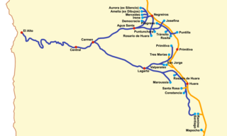
The Ferrocarril de Agua Santa was a railway line in the old province of Tarapacá in Chile between 1890 and 1931.

The paradas method was a process to extract nitrate from caliche by leaching. In this method caliche was boiled in water in large pans called "paradas". It was a firewood and labour-intensive process. The paradas method was phased out in the 1850s by a new system invented by Pedro Gamboni which required less fuel and labour.

<span class="mw-page-title-main">Calatambo Albarracín</span> Chilean composer and folklorist (1924–2018)

Calatambo Albarracín, born Freddy Albarracín Iribarren, was a Chilean composer and folklorist identified with the music of northern Chile.

References

  1. "Album Desierto - History about Nitrate (English)".
  2. History of the Haber process
  3. The data was retrieved on 19 January 2013 and was selected from records with "Oficina" as a place name.