San Saba County is a county located on the Edwards Plateau in western Central Texas. As of the 2010 census, its population was 6,131. Its county seat is San Saba. The county is named after the San Saba River, which flows through the county.
San Saba is a city located in Central Texas. It was settled in 1854 and named for its location on the San Saba River. The population was 3,099 at the 2010 census. It is the county seat of San Saba County.
Lipan Apache are Southern Athabaskan (Apachean) Native Americans whose traditional territory included present-day Texas, New Mexico, Colorado, and the northern Mexican states of Chihuahua, Nuevo León, Coahuila, and Tamaulipas, prior to the 17th century.
Concha and Concho means "shell" in the Spanish and Portuguese languages. The word can also refer to:
These historic properties and districts in the state of Texas are listed in the National Register of Historic Places. Properties and/or districts are listed in most of Texas's 254 counties.
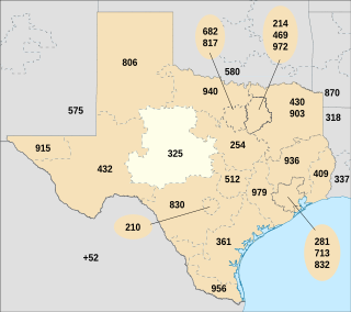
North American area code 325 is a state of Texas area code for telephone numbers in the Abilene and San Angelo areas. It was created, along with area code 432, on April 5, 2003, in a split from area code 915.

Bend is an unincorporated community in Lampasas and San Saba Counties in Western Central Texas. The population was 1,678 as of the 2010 census. It is located on Farm to Market Road 580 on the western leg of a horseshoe-shaped bend in the Colorado River. The Lampasas County portion of Bend is part of the Killeen–Temple–Fort Hood Metropolitan Statistical Area.

Fort McKavett State Historic Site is located in Menard County, Texas, United States. Fort McKavett was a frontier fort established as Camp on the San Saba in 1852 to protect settlers from Indian raids. The camp was renamed in honor of Captain Henry McKavett, who was killed in the Mexican–American War battle of Monterrey.
Central Texas Electric Cooperative, Inc. is a rural utility cooperative headquartered in Fredericksburg, Texas, with suboffices in Kingsland, Texas; Llano, Texas; and Mason, Texas.

The North Concho River is a river in west-central Texas and one of three tributaries of the Concho River. The river is 88 miles (142 km) long. The other two tributaries are the Middle Concho and South Concho Rivers. The Concho River flows into the Colorado River.
Pecan Bayou may refer to:
Pecan Bayou is a slow-moving stream in Callahan County, Texas. The stream is fed by over twenty creeks and is one of the major tributaries of the Colorado River in Texas. It may be the westernmost bayou in the United States. A dam on Pecan Bayou seven miles north of Brownwood forms Lake Brownwood.
Lake Merritt is a small, private manmade lake on Brown's Creek, located about 7 miles north of Goldthwaite, Texas in Mills County. Initially constructed by the Santa Fe Railway Company as a reservoir for their steam engines, the lake is now used for recreation.

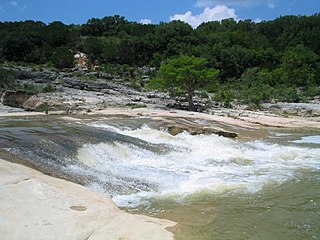
Balcones Canyonlands is a national wildlife refuge located in the Texas Hill Country to the northwest of Austin. The refuge was formed in 1992 to conserve habitat for two endangered songbirds including the golden-cheeked warbler and the black-capped vireo and to preserve Texas Hill Country habitat for numerous other wildlife species. The refuge augments a similarly named preserve in Austin called the Balcones Canyonlands Preserve.

The Pinta Trail is an historic trail in Central Texas that was first traveled by indigenous tribes, and later explorers, settlers, soldiers, and travelers. The 19th-century Germans who settled the Texas Hill Country used part of the Pinta Trail on their journey northward from New Braunfels to found Fredericksburg. An historic battle between a Texas Rangers patrol and a band of Comanches is often said to have occurred near a ford where the Pinta Trail crossed the Guadalupe River.
This page is based on this
Wikipedia article Text is available under the
CC BY-SA 4.0 license; additional terms may apply.
Images, videos and audio are available under their respective licenses.